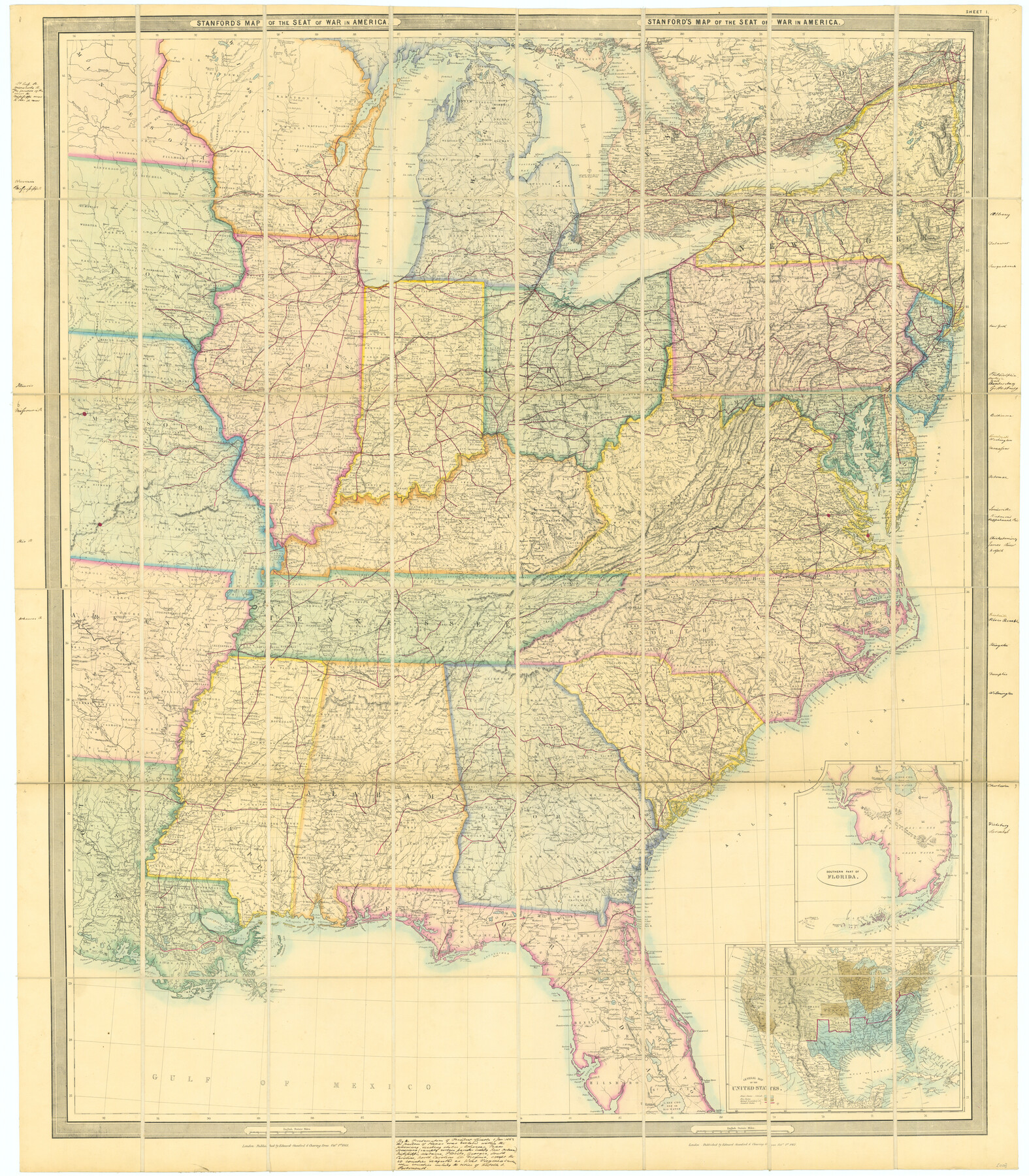
Stanford's Map of the Seat of War in America
-
Map/Doc
76231
-
Collection
Texas State Library and Archives
-
Object Dates
1861 (Creation Date)
-
People and Organizations
Edward Stanford (Publisher)
-
Subjects
United States
-
Height x Width
52.2 x 45.7 inches
132.6 x 116.1 cm
-
Comments
Prints available courtesy of the Texas State Library and Archives.
More info can be found here: TSLAC Map 01100
Part of: Texas State Library and Archives
General Highway Map, Castro County, Texas

Print $20.00
General Highway Map, Castro County, Texas
1961
Size 18.2 x 24.7 inches
Map/Doc 79403
General Highway Map, Cottle County, Texas

Print $20.00
General Highway Map, Cottle County, Texas
1940
Size 18.3 x 25.2 inches
Map/Doc 79060
General Highway Map, San Patricio County, Texas

Print $20.00
General Highway Map, San Patricio County, Texas
1961
Size 18.1 x 24.5 inches
Map/Doc 79647
General Highway Map, Jim Wells County, Texas

Print $20.00
General Highway Map, Jim Wells County, Texas
1940
Size 18.4 x 24.8 inches
Map/Doc 79148
General Highway Map, Bailey County, Texas

Print $20.00
General Highway Map, Bailey County, Texas
1961
Size 25.0 x 18.2 inches
Map/Doc 79359
A Map of Louisiana and Mexico

Print $20.00
A Map of Louisiana and Mexico
1820
Size 43.0 x 32.6 inches
Map/Doc 76218
A New Map of Texas with the Contiguous American & Mexican States

Print $20.00
A New Map of Texas with the Contiguous American & Mexican States
1835
Size 13.5 x 16.1 inches
Map/Doc 76185
Railroad and County Map of Texas

Print $20.00
Railroad and County Map of Texas
1901
Size 33.1 x 37.1 inches
Map/Doc 76213
General Highway Map. Detail of Cities and Towns in Walker County, Texas [Huntsville and vicinity]
![79699, General Highway Map. Detail of Cities and Towns in Walker County, Texas [Huntsville and vicinity], Texas State Library and Archives](https://historictexasmaps.com/wmedia_w700/maps/79699.tif.jpg)
Print $20.00
General Highway Map. Detail of Cities and Towns in Walker County, Texas [Huntsville and vicinity]
1961
Size 18.1 x 24.8 inches
Map/Doc 79699
General Highway Map. Detail of Cities and Towns in Bexar County, Texas. City Map of San Antonio, Alamo Heights, Olmos Park, Terrell Hills, Castle Hills, Balcones Heights, and vicinity, Bexar County, Texas

Print $20.00
General Highway Map. Detail of Cities and Towns in Bexar County, Texas. City Map of San Antonio, Alamo Heights, Olmos Park, Terrell Hills, Castle Hills, Balcones Heights, and vicinity, Bexar County, Texas
1961
Size 18.2 x 25.0 inches
Map/Doc 79375
General Highway Map, Newton County, Texas

Print $20.00
General Highway Map, Newton County, Texas
1961
Size 19.3 x 25.0 inches
Map/Doc 79612
General Highway Map. Detail of Cities and Towns in Dallas County, Texas [Dallas and vicinity]
![79433, General Highway Map. Detail of Cities and Towns in Dallas County, Texas [Dallas and vicinity], Texas State Library and Archives](https://historictexasmaps.com/wmedia_w700/maps/79433.tif.jpg)
Print $20.00
General Highway Map. Detail of Cities and Towns in Dallas County, Texas [Dallas and vicinity]
1961
Size 18.1 x 24.5 inches
Map/Doc 79433
You may also like
Llano County Sketch File 8

Print $10.00
- Digital $50.00
Llano County Sketch File 8
1885
Size 14.1 x 8.8 inches
Map/Doc 30364
Map of the United States Engraved to Illustrate Mitchell's School and Family Geography

Print $20.00
Map of the United States Engraved to Illustrate Mitchell's School and Family Geography
1839
Size 11.6 x 17.4 inches
Map/Doc 79734
Working Sketch No. II in Pecos County

Print $20.00
- Digital $50.00
Working Sketch No. II in Pecos County
1886
Size 31.3 x 24.1 inches
Map/Doc 3953
Culberson County Rolled Sketch 63

Print $20.00
- Digital $50.00
Culberson County Rolled Sketch 63
1986
Size 19.4 x 24.3 inches
Map/Doc 5679
Navarro County Sketch File 3

Print $8.00
- Digital $50.00
Navarro County Sketch File 3
1847
Size 10.2 x 8.1 inches
Map/Doc 32300
Flight Mission No. BRA-16M, Frame 55, Jefferson County

Print $20.00
- Digital $50.00
Flight Mission No. BRA-16M, Frame 55, Jefferson County
1953
Size 18.4 x 22.4 inches
Map/Doc 85672
Travis County Sketch File 30

Print $6.00
- Digital $50.00
Travis County Sketch File 30
1884
Size 17.0 x 11.0 inches
Map/Doc 38343
Starr County Rolled Sketch 33

Print $20.00
- Digital $50.00
Starr County Rolled Sketch 33
1944
Size 21.9 x 30.8 inches
Map/Doc 7830
Liberty County Rolled Sketch C

Print $20.00
- Digital $50.00
Liberty County Rolled Sketch C
1941
Size 39.5 x 35.4 inches
Map/Doc 9571
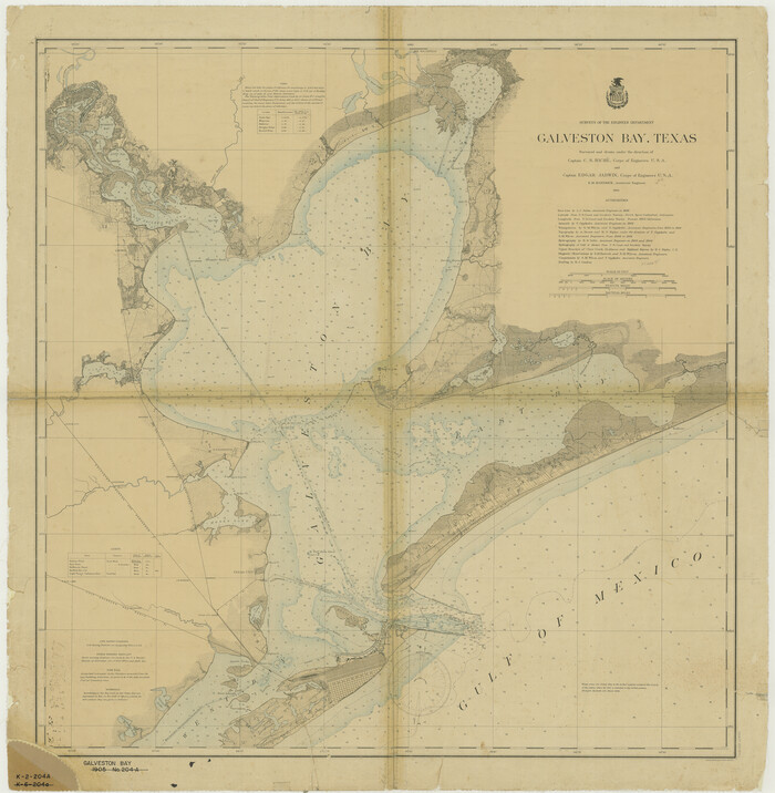
Galveston Bay
Print $20.00
- Digital $50.00
Galveston Bay
1905
Size 37.5 x 36.7 inches
Map/Doc 69870
Cherokee County Sketch File 16

Print $44.00
- Digital $50.00
Cherokee County Sketch File 16
1862
Size 10.0 x 8.0 inches
Map/Doc 18152
Presidio County Boundary File 5

Print $8.00
- Digital $50.00
Presidio County Boundary File 5
Size 10.3 x 8.2 inches
Map/Doc 58087