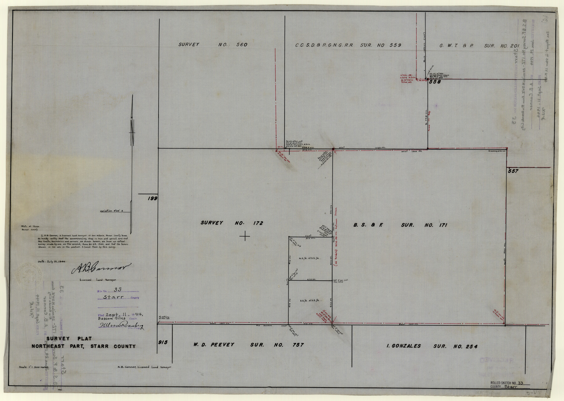
Starr County Rolled Sketch 33
Survey plat, northeast part, Starr County
-
Map/Doc
7830
-
Collection
General Map Collection
-
Object Dates
1944/7/31 (Creation Date)
1944/9/11 (File Date)
1944/6/29 (Survey Date)
-
People and Organizations
A.B. Connor (Surveyor/Engineer)
-
Counties
Starr
-
Subjects
Surveying Rolled Sketch
-
Height x Width
21.9 x 30.8 inches
55.6 x 78.2 cm
-
Medium
linen, manuscript
-
Scale
1" = 200 varas
Related maps
Starr County Sketch File 44

Print $8.00
- Digital $50.00
Starr County Sketch File 44
1944
Size 14.1 x 8.8 inches
Map/Doc 36995
Part of: General Map Collection
Anderson County Boundary File 5

Print $10.00
- Digital $50.00
Anderson County Boundary File 5
Size 8.1 x 7.2 inches
Map/Doc 49742
Hill County Sketch File 20

Print $22.00
- Digital $50.00
Hill County Sketch File 20
1854
Size 8.3 x 7.7 inches
Map/Doc 26490
Flight Mission No. DQN-2K, Frame 38, Calhoun County

Print $20.00
- Digital $50.00
Flight Mission No. DQN-2K, Frame 38, Calhoun County
1953
Size 15.5 x 15.4 inches
Map/Doc 84243
Liberty County Working Sketch 49b

Print $20.00
- Digital $50.00
Liberty County Working Sketch 49b
1955
Size 28.0 x 31.0 inches
Map/Doc 70509
Flight Mission No. DCL-6C, Frame 66, Kenedy County

Print $20.00
- Digital $50.00
Flight Mission No. DCL-6C, Frame 66, Kenedy County
1943
Size 18.7 x 22.4 inches
Map/Doc 85908
Wilbarger County Sketch File 29

Print $18.00
- Digital $50.00
Wilbarger County Sketch File 29
2016
Size 11.0 x 8.5 inches
Map/Doc 95325
Hopkins County Rolled Sketch 28

Print $20.00
- Digital $50.00
Hopkins County Rolled Sketch 28
Size 25.3 x 19.9 inches
Map/Doc 6225
Baylor County Sketch File 32

Print $10.00
- Digital $50.00
Baylor County Sketch File 32
Size 10.2 x 8.2 inches
Map/Doc 14238
Flight Mission No. CRK-5P, Frame 126, Refugio County

Print $20.00
- Digital $50.00
Flight Mission No. CRK-5P, Frame 126, Refugio County
1956
Size 18.7 x 22.4 inches
Map/Doc 86929
Sulphur River, Talco Sheet

Print $20.00
- Digital $50.00
Sulphur River, Talco Sheet
1917
Size 24.6 x 43.7 inches
Map/Doc 65160
Shelby County Sketch File 26

Print $4.00
- Digital $50.00
Shelby County Sketch File 26
Size 8.1 x 8.1 inches
Map/Doc 36660
[Tom Green County]
![16901, [Tom Green County], General Map Collection](https://historictexasmaps.com/wmedia_w700/maps/16901.tif.jpg)
Print $20.00
- Digital $50.00
[Tom Green County]
1888
Size 33.2 x 34.4 inches
Map/Doc 16901
You may also like
Brazoria County NRC Article 33.136 Sketch 34

Print $24.00
Brazoria County NRC Article 33.136 Sketch 34
2025
Map/Doc 97478
Aransas County Sketch File 25

Print $20.00
- Digital $50.00
Aransas County Sketch File 25
Size 17.0 x 17.5 inches
Map/Doc 13218
Jackson County Sketch File 6a

Print $30.00
- Digital $50.00
Jackson County Sketch File 6a
1894
Size 13.6 x 8.8 inches
Map/Doc 27634
Bee County Sketch File 5

Print $40.00
- Digital $50.00
Bee County Sketch File 5
Size 27.4 x 23.4 inches
Map/Doc 10914
Harrison County Working Sketch 7

Print $20.00
- Digital $50.00
Harrison County Working Sketch 7
1955
Size 32.0 x 39.0 inches
Map/Doc 66027
[The S.K. Ry. of Texas, State Line to Pecos, Reeves Co., Texas]
![64161, [The S.K. Ry. of Texas, State Line to Pecos, Reeves Co., Texas], General Map Collection](https://historictexasmaps.com/wmedia_w700/maps/64161.tif.jpg)
Print $40.00
- Digital $50.00
[The S.K. Ry. of Texas, State Line to Pecos, Reeves Co., Texas]
1910
Size 19.2 x 120.9 inches
Map/Doc 64161
Flight Mission No. CGI-4N, Frame 25, Cameron County

Print $20.00
- Digital $50.00
Flight Mission No. CGI-4N, Frame 25, Cameron County
1954
Size 18.7 x 22.4 inches
Map/Doc 84658
Reagan County Rolled Sketch 8

Print $20.00
- Digital $50.00
Reagan County Rolled Sketch 8
Size 30.2 x 26.7 inches
Map/Doc 7436
Val Verde County Rolled Sketch 66

Print $40.00
- Digital $50.00
Val Verde County Rolled Sketch 66
1957
Size 30.7 x 55.0 inches
Map/Doc 10084
Burnet County Working Sketch 15

Print $20.00
- Digital $50.00
Burnet County Working Sketch 15
1979
Size 38.2 x 30.4 inches
Map/Doc 67858
Bell County Sketch File 26b

Print $40.00
- Digital $50.00
Bell County Sketch File 26b
Size 14.7 x 21.1 inches
Map/Doc 10917
Map of Harrison County

Print $20.00
- Digital $50.00
Map of Harrison County
1911
Size 43.8 x 39.8 inches
Map/Doc 4698