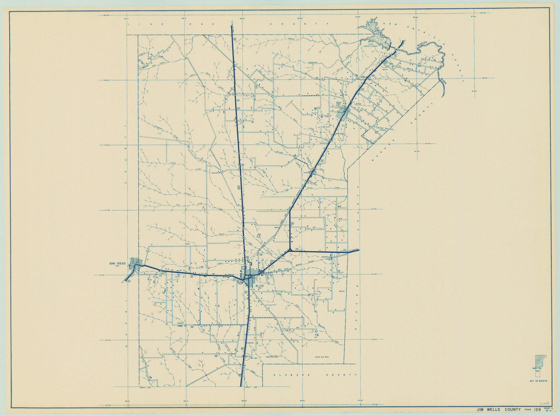
General Highway Map, Jim Wells County, Texas
-
Map/Doc
79148
-
Collection
Texas State Library and Archives
-
Object Dates
1940 (Creation Date)
-
People and Organizations
Texas State Highway Department (Publisher)
-
Counties
Jim Wells
-
Subjects
County
-
Height x Width
18.4 x 24.8 inches
46.7 x 63.0 cm
-
Comments
Prints available courtesy of the Texas State Library and Archives.
More info can be found here: TSLAC Map 04909
Part of: Texas State Library and Archives
General Highway Map, Llano County, Texas

Print $20.00
General Highway Map, Llano County, Texas
1940
Size 18.4 x 24.9 inches
Map/Doc 79178
General Highway Map, Panola County, Texas

Print $20.00
General Highway Map, Panola County, Texas
1961
Size 18.1 x 24.5 inches
Map/Doc 79624
Map of Texas with Parts of the Adjoining States

Print $20.00
Map of Texas with Parts of the Adjoining States
1836
Size 29.5 x 23.6 inches
Map/Doc 76193
General Highway Map, Collin County, Texas

Print $20.00
General Highway Map, Collin County, Texas
1961
Size 18.2 x 24.6 inches
Map/Doc 79413
General Highway Map, Hartley County, Texas

Print $20.00
General Highway Map, Hartley County, Texas
1961
Size 24.4 x 18.0 inches
Map/Doc 79511
General Highway Map, Sherman County, Texas

Print $20.00
General Highway Map, Sherman County, Texas
1961
Size 18.2 x 24.8 inches
Map/Doc 79653
General Highway Map, Edwards County, Real County, Texas

Print $20.00
General Highway Map, Edwards County, Real County, Texas
1961
Size 18.1 x 24.7 inches
Map/Doc 79452
Principal Highways of the Southwest with particular reference to New Mexico, Oklahoma, Texas, Arkansas and Louisiana

Print $20.00
Principal Highways of the Southwest with particular reference to New Mexico, Oklahoma, Texas, Arkansas and Louisiana
1933
Size 24.3 x 18.4 inches
Map/Doc 76302
General Highway Map, Culberson County, Texas

Print $20.00
General Highway Map, Culberson County, Texas
1961
Size 24.9 x 18.2 inches
Map/Doc 79427
General Highway Map, Lee County, Texas

Print $20.00
General Highway Map, Lee County, Texas
1940
Size 18.4 x 24.9 inches
Map/Doc 79171
General Highway Map, Live Oak County, Texas

Print $20.00
General Highway Map, Live Oak County, Texas
1961
Size 18.3 x 24.8 inches
Map/Doc 79575
Stanford's Map of the Seat of War in America

Print $40.00
Stanford's Map of the Seat of War in America
1861
Size 52.2 x 45.7 inches
Map/Doc 76231
You may also like
Flight Mission No. BRE-2P, Frame 64, Nueces County

Print $20.00
- Digital $50.00
Flight Mission No. BRE-2P, Frame 64, Nueces County
1956
Size 18.5 x 22.6 inches
Map/Doc 86759
Coleman County Sketch File 43

Print $12.00
- Digital $50.00
Coleman County Sketch File 43
1892
Size 9.2 x 8.8 inches
Map/Doc 18775
Taylor County Sketch File 13

Print $8.00
- Digital $50.00
Taylor County Sketch File 13
1913
Size 9.1 x 8.5 inches
Map/Doc 37798
Bowie County Working Sketch 21

Print $20.00
- Digital $50.00
Bowie County Working Sketch 21
1968
Size 35.9 x 36.3 inches
Map/Doc 67425
Flight Mission No. DAG-21K, Frame 40, Matagorda County

Print $20.00
- Digital $50.00
Flight Mission No. DAG-21K, Frame 40, Matagorda County
1952
Size 18.6 x 19.3 inches
Map/Doc 86407
Flight Mission No. DCL-6C, Frame 79, Kenedy County

Print $20.00
- Digital $50.00
Flight Mission No. DCL-6C, Frame 79, Kenedy County
1943
Size 18.6 x 22.4 inches
Map/Doc 85921
Coryell County Working Sketch 30

Print $20.00
- Digital $50.00
Coryell County Working Sketch 30
2001
Size 37.1 x 38.7 inches
Map/Doc 68237
Knox County Sketch File 24

Print $6.00
- Digital $50.00
Knox County Sketch File 24
1945
Size 14.2 x 9.0 inches
Map/Doc 29254
Edwards County Sketch File 49

Print $20.00
- Digital $50.00
Edwards County Sketch File 49
1958
Size 25.6 x 27.9 inches
Map/Doc 11444
[Capitol Leagues 217, 218, 219 and 220]
![91460, [Capitol Leagues 217, 218, 219 and 220], Twichell Survey Records](https://historictexasmaps.com/wmedia_w700/maps/91460-1.tif.jpg)
Print $20.00
- Digital $50.00
[Capitol Leagues 217, 218, 219 and 220]
Size 23.2 x 10.3 inches
Map/Doc 91460
![88993, San Jacinto Co[unty], Library of Congress](https://historictexasmaps.com/wmedia_w700/maps/88993.tif.jpg)
[Blocks K-7, K-8, Leagues 443-446, 390, 392, 407-410]
![90543, [Blocks K-7, K-8, Leagues 443-446, 390, 392, 407-410], Twichell Survey Records](https://historictexasmaps.com/wmedia_w700/maps/90543-1.tif.jpg)
Print $3.00
- Digital $50.00
[Blocks K-7, K-8, Leagues 443-446, 390, 392, 407-410]
Size 10.4 x 14.2 inches
Map/Doc 90543