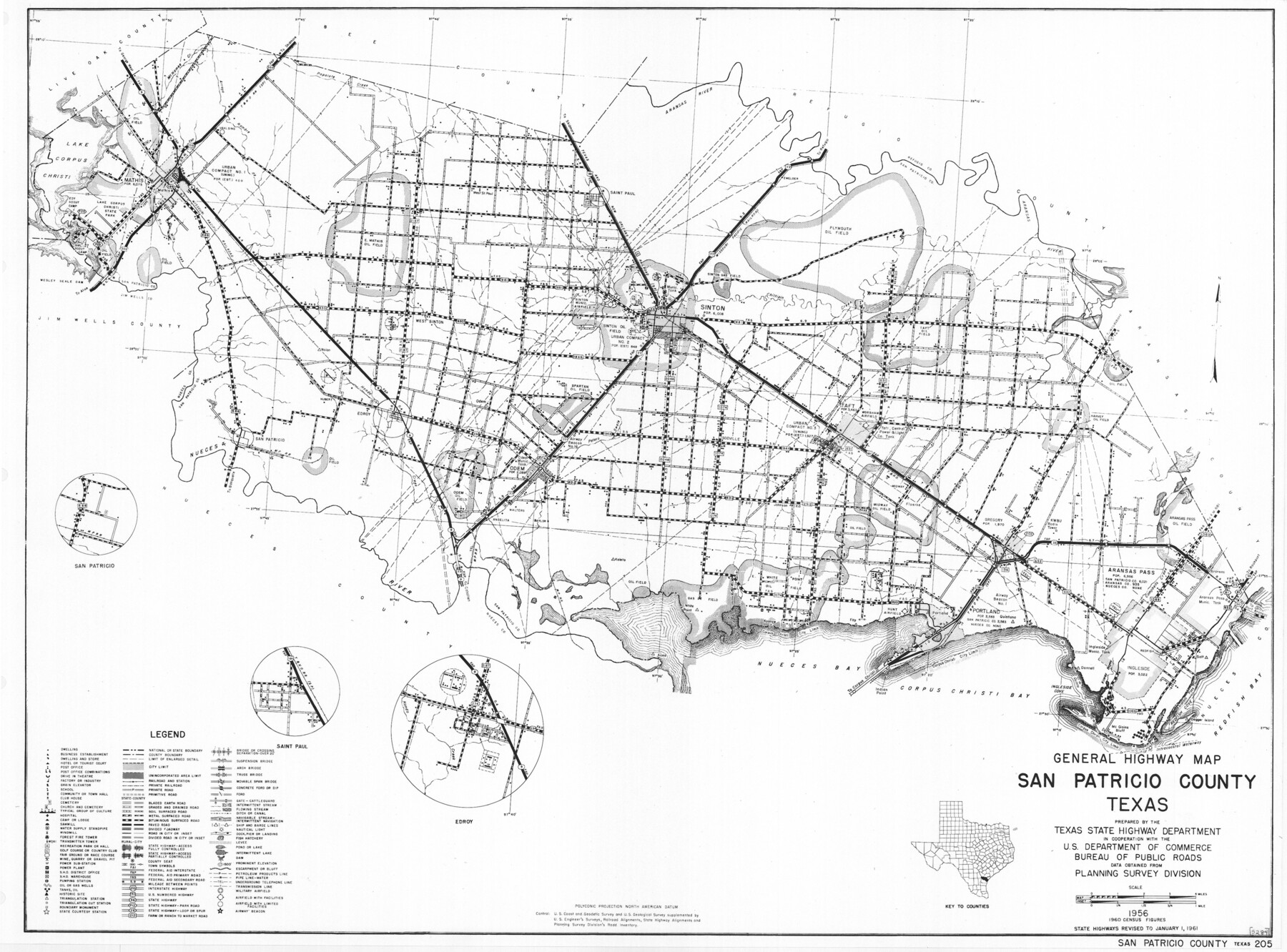
General Highway Map, San Patricio County, Texas
-
Map/Doc
79647
-
Collection
Texas State Library and Archives
-
Object Dates
1961 (Creation Date)
-
People and Organizations
Texas State Highway Department (Publisher)
-
Counties
San Patricio
-
Subjects
County
-
Height x Width
18.1 x 24.5 inches
46.0 x 62.2 cm
-
Comments
Prints available courtesy of the Texas State Library and Archives.
More info can be found here: TSLAC Map 05284
Part of: Texas State Library and Archives
General Highway Map, Lynn County, Texas

Print $20.00
General Highway Map, Lynn County, Texas
1940
Size 18.2 x 24.9 inches
Map/Doc 79182
General Highway Map. Detail of Cities and Towns in Tarrant County, Texas [Fort Worth and vicinity]
![79252, General Highway Map. Detail of Cities and Towns in Tarrant County, Texas [Fort Worth and vicinity], Texas State Library and Archives](https://historictexasmaps.com/wmedia_w700/maps/79252-GC.tif.jpg)
Print $20.00
General Highway Map. Detail of Cities and Towns in Tarrant County, Texas [Fort Worth and vicinity]
1940
Size 24.9 x 18.2 inches
Map/Doc 79252
General Highway Map, Cochran County, Texas

Print $20.00
General Highway Map, Cochran County, Texas
1940
Size 25.2 x 18.5 inches
Map/Doc 79048
General Highway Map, Kleberg County, Texas

Print $20.00
General Highway Map, Kleberg County, Texas
1961
Size 24.8 x 18.3 inches
Map/Doc 79558
General Highway Map, Montague County, Texas

Print $20.00
General Highway Map, Montague County, Texas
1961
Size 24.8 x 18.2 inches
Map/Doc 79601
General Highway Map, Kinney County, Uvalde County, Texas

Print $20.00
General Highway Map, Kinney County, Uvalde County, Texas
1940
Size 18.4 x 24.8 inches
Map/Doc 79162
General Highway Map, Bowie County, Texas

Print $20.00
General Highway Map, Bowie County, Texas
1961
Size 18.2 x 25.0 inches
Map/Doc 79380
General Highway Map, Coryell County, Texas

Print $20.00
General Highway Map, Coryell County, Texas
1961
Size 18.1 x 24.8 inches
Map/Doc 79422
General Highway Map, Midland County, Texas

Print $20.00
General Highway Map, Midland County, Texas
1940
Size 18.2 x 24.5 inches
Map/Doc 79197
General Highway Map, Denton County, Texas

Print $20.00
General Highway Map, Denton County, Texas
1961
Size 18.2 x 24.5 inches
Map/Doc 79441
A New Map of the United States of America

Print $20.00
A New Map of the United States of America
1856
Size 17.8 x 28.0 inches
Map/Doc 79320
General Highway Map, Hansford County, Texas

Print $20.00
General Highway Map, Hansford County, Texas
1961
Size 18.0 x 24.5 inches
Map/Doc 79497
You may also like
Blanco County Working Sketch 33

Print $40.00
- Digital $50.00
Blanco County Working Sketch 33
1978
Size 41.0 x 57.5 inches
Map/Doc 67393
Matagorda County NRC Article 33.136 Sketch 15

Print $42.00
- Digital $50.00
Matagorda County NRC Article 33.136 Sketch 15
Size 23.8 x 35.9 inches
Map/Doc 95739
Clay County Sketch File 27

Print $20.00
- Digital $50.00
Clay County Sketch File 27
1900
Size 18.8 x 16.5 inches
Map/Doc 11089
Red River County Working Sketch 14

Print $20.00
- Digital $50.00
Red River County Working Sketch 14
1952
Size 37.8 x 22.9 inches
Map/Doc 71997
Hutchinson County Sketch File 15

Print $20.00
- Digital $50.00
Hutchinson County Sketch File 15
Size 20.7 x 26.7 inches
Map/Doc 11813
Zavala County Sketch File A

Print $10.00
- Digital $50.00
Zavala County Sketch File A
1893
Size 8.7 x 7.9 inches
Map/Doc 41433
Harris County Sketch File 90

Print $46.00
- Digital $50.00
Harris County Sketch File 90
1967
Size 12.2 x 14.4 inches
Map/Doc 25596
Morris County Rolled Sketch 2A

Print $20.00
- Digital $50.00
Morris County Rolled Sketch 2A
Size 22.7 x 17.6 inches
Map/Doc 10268
Taylor County

Print $20.00
- Digital $50.00
Taylor County
1934
Size 44.8 x 39.0 inches
Map/Doc 95650
Leon County Rolled Sketch 34

Print $20.00
- Digital $50.00
Leon County Rolled Sketch 34
1999
Size 31.8 x 37.1 inches
Map/Doc 87502
Ward County Working Sketch 51

Print $40.00
- Digital $50.00
Ward County Working Sketch 51
1980
Size 34.4 x 52.1 inches
Map/Doc 72357
Dimmit County Working Sketch 40

Print $40.00
- Digital $50.00
Dimmit County Working Sketch 40
1968
Size 42.9 x 59.0 inches
Map/Doc 68701