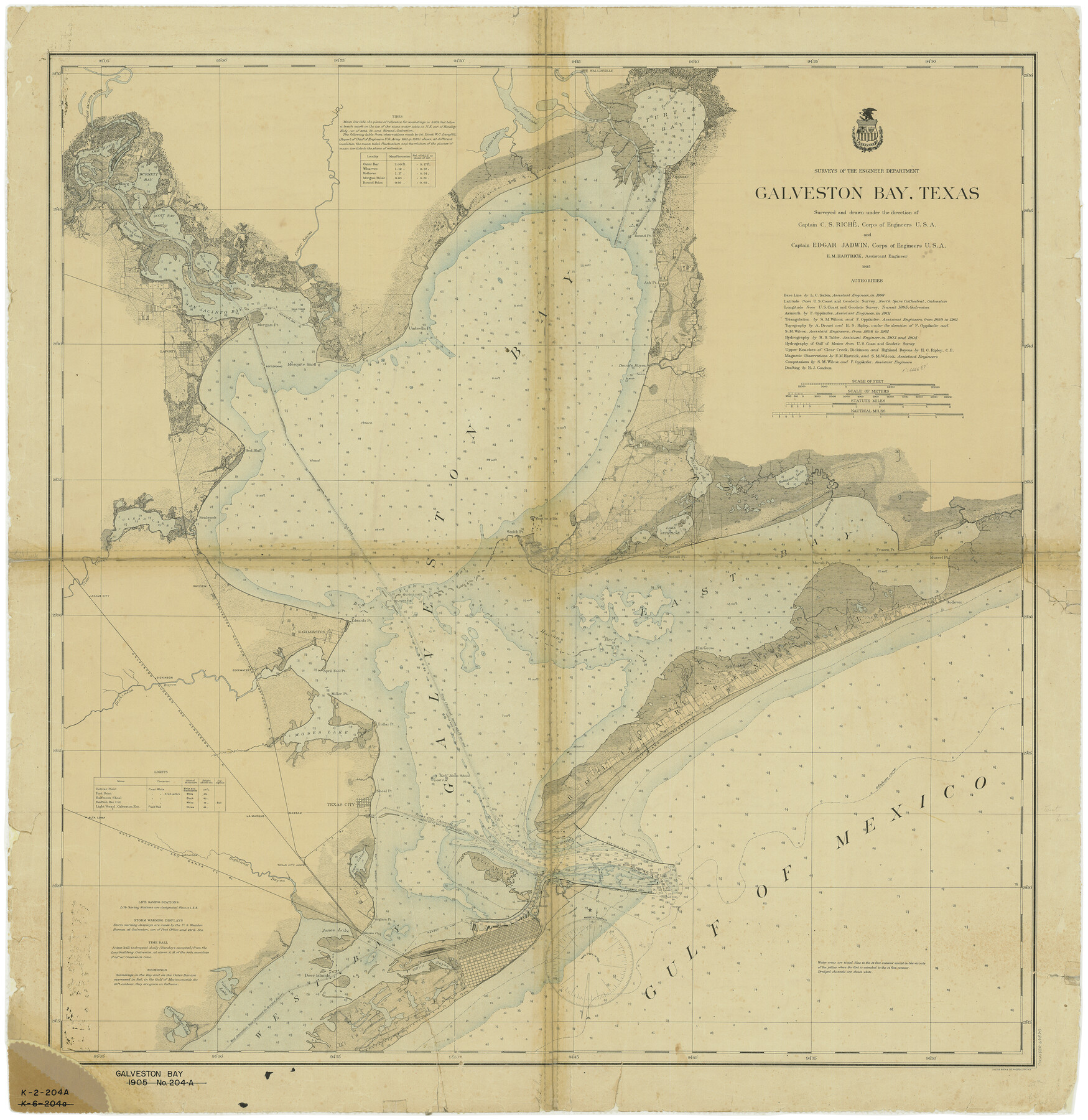
Galveston Bay
K-2-204b
-
Map/Doc
69870
-
Collection
General Map Collection
-
Object Dates
1905 (Creation Date)
-
Counties
Galveston Chambers Harris
-
Subjects
Nautical Charts
-
Height x Width
37.5 x 36.7 inches
95.3 x 93.2 cm
Part of: General Map Collection
Bell County Working Sketch 16

Print $20.00
- Digital $50.00
Bell County Working Sketch 16
1983
Size 46.5 x 35.4 inches
Map/Doc 67356
Colonial Texas. 1822 to 1834.

Print $20.00
- Digital $50.00
Colonial Texas. 1822 to 1834.
1897
Size 12.8 x 16.3 inches
Map/Doc 93410
Presidio County Working Sketch 74

Print $20.00
- Digital $50.00
Presidio County Working Sketch 74
1962
Size 45.9 x 35.2 inches
Map/Doc 71751
Martin County Working Sketch 7

Print $20.00
- Digital $50.00
Martin County Working Sketch 7
1971
Size 43.0 x 31.3 inches
Map/Doc 70825
Eastland County Working Sketch 7

Print $3.00
- Digital $50.00
Eastland County Working Sketch 7
1918
Size 15.6 x 10.7 inches
Map/Doc 68788
Culberson County Working Sketch 33

Print $20.00
- Digital $50.00
Culberson County Working Sketch 33
1960
Size 26.9 x 34.1 inches
Map/Doc 68486
Fannin County Sketch File 26

Print $4.00
- Digital $50.00
Fannin County Sketch File 26
1873
Size 8.5 x 10.3 inches
Map/Doc 22495
Newton County Sketch File 42

Print $39.00
- Digital $50.00
Newton County Sketch File 42
1936
Size 13.2 x 8.7 inches
Map/Doc 32425
Duval County Rolled Sketch 30A

Print $40.00
- Digital $50.00
Duval County Rolled Sketch 30A
1896
Size 59.7 x 40.8 inches
Map/Doc 76145
Wharton County Rolled Sketch 12

Print $20.00
- Digital $50.00
Wharton County Rolled Sketch 12
1986
Size 31.1 x 23.7 inches
Map/Doc 8237
Jasper County Working Sketch 21

Print $20.00
- Digital $50.00
Jasper County Working Sketch 21
1941
Size 13.1 x 21.4 inches
Map/Doc 66483
Bexar County Rolled Sketch 4

Print $20.00
- Digital $50.00
Bexar County Rolled Sketch 4
Size 24.3 x 36.8 inches
Map/Doc 5137
You may also like
19th Congressional District of Texas

Print $20.00
- Digital $50.00
19th Congressional District of Texas
Size 33.1 x 28.9 inches
Map/Doc 92610
Austin County Sketch File 16

Print $74.00
- Digital $50.00
Austin County Sketch File 16
Size 14.3 x 8.8 inches
Map/Doc 13888
[Location Survey of the Southern Kansas Railway, Kiowa Extension from a point in Drake's Location, in Indian Territory 100 miles from south line of Kansas, continuing up Wolf Creek and South Canadian River to Cottonwood Creek in Hutchinson County]
![88840, [Location Survey of the Southern Kansas Railway, Kiowa Extension from a point in Drake's Location, in Indian Territory 100 miles from south line of Kansas, continuing up Wolf Creek and South Canadian River to Cottonwood Creek in Hutchinson County], General Map Collection](https://historictexasmaps.com/wmedia_w700/maps/88840.tif.jpg)
Print $20.00
- Digital $50.00
[Location Survey of the Southern Kansas Railway, Kiowa Extension from a point in Drake's Location, in Indian Territory 100 miles from south line of Kansas, continuing up Wolf Creek and South Canadian River to Cottonwood Creek in Hutchinson County]
1886
Size 39.1 x 38.0 inches
Map/Doc 88840
General Highway Map, Delta County, Hopkins County, Texas

Print $20.00
General Highway Map, Delta County, Hopkins County, Texas
1961
Size 24.6 x 18.2 inches
Map/Doc 79439
Map of the State of Texas

Print $20.00
- Digital $50.00
Map of the State of Texas
1881
Size 15.7 x 21.7 inches
Map/Doc 96614
Flight Mission No. BRE-1P, Frame 78, Nueces County

Print $20.00
- Digital $50.00
Flight Mission No. BRE-1P, Frame 78, Nueces County
1956
Size 18.6 x 22.4 inches
Map/Doc 86660
Lampasas County Working Sketch 6

Print $20.00
- Digital $50.00
Lampasas County Working Sketch 6
1950
Size 29.5 x 20.6 inches
Map/Doc 70283
Fort Bend County Sketch File 10

Print $20.00
- Digital $50.00
Fort Bend County Sketch File 10
Size 16.9 x 24.9 inches
Map/Doc 11501
Uvalde County Boundary File 3

Print $28.00
- Digital $50.00
Uvalde County Boundary File 3
Size 13.1 x 8.4 inches
Map/Doc 59558
University of Texas System University Lands

Print $20.00
- Digital $50.00
University of Texas System University Lands
1929
Size 23.2 x 17.7 inches
Map/Doc 93246
Zapata County Sketch File 6

Print $22.00
- Digital $50.00
Zapata County Sketch File 6
1913
Size 22.1 x 32.7 inches
Map/Doc 12720
[Map of Parker County]
![3948, [Map of Parker County], General Map Collection](https://historictexasmaps.com/wmedia_w700/maps/3948.tif.jpg)
Print $20.00
- Digital $50.00
[Map of Parker County]
1889
Size 25.9 x 32.9 inches
Map/Doc 3948