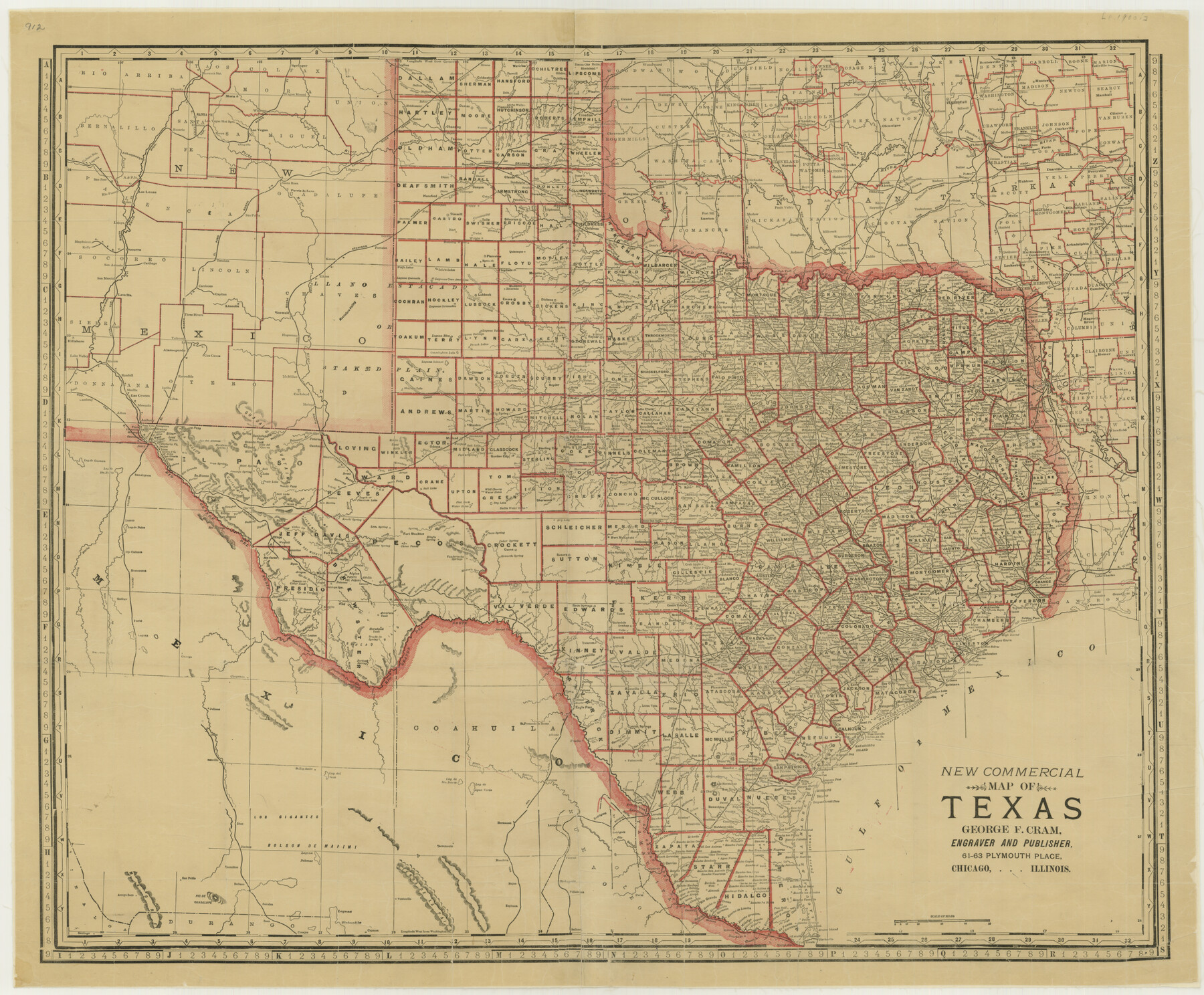
New Commercial Map of Texas
-
Map/Doc
76199
-
Collection
Texas State Library and Archives
-
Object Dates
1900 (Creation Date)
-
People and Organizations
George F. Cram (Publisher)
-
Subjects
State of Texas
-
Height x Width
28.1 x 34.0 inches
71.4 x 86.4 cm
-
Comments
Prints available courtesy of the Texas State Library and Archives.
More info can be found here: TSLAC Map 00912
Part of: Texas State Library and Archives
General Highway Map, Yoakum County, Texas

Print $20.00
General Highway Map, Yoakum County, Texas
1940
Size 18.3 x 24.9 inches
Map/Doc 79285
General Highway Map, Navarro County, Texas

Print $20.00
General Highway Map, Navarro County, Texas
1961
Size 19.3 x 25.0 inches
Map/Doc 79610
Texas Oil and Gas Fields and Truck Pipe Line Systems

Print $20.00
Texas Oil and Gas Fields and Truck Pipe Line Systems
1926
Size 21.7 x 30.8 inches
Map/Doc 79327
General Highway Map, Wise County, Texas

Print $20.00
General Highway Map, Wise County, Texas
1940
Size 18.2 x 24.8 inches
Map/Doc 79284
General Highway Map, Waller County, Texas

Print $20.00
General Highway Map, Waller County, Texas
1939
Size 25.1 x 18.5 inches
Map/Doc 79270
General Highway Map, Gray County, Texas

Print $20.00
General Highway Map, Gray County, Texas
1961
Size 18.1 x 24.7 inches
Map/Doc 79483
General Highway Map. Detail of Cities and Towns in Harris County, Texas. City Map [of] Houston, Pasadena, West University Place, Bellaire, Galena Park, Jacinto City, South Houston, South Side Place, Deer Park, and vicinity, Harris County, Texas
![79505, General Highway Map. Detail of Cities and Towns in Harris County, Texas. City Map [of] Houston, Pasadena, West University Place, Bellaire, Galena Park, Jacinto City, South Houston, South Side Place, Deer Park, and vicinity, Harris County, Texas, Texas State Library and Archives](https://historictexasmaps.com/wmedia_w700/maps/79505.tif.jpg)
Print $20.00
General Highway Map. Detail of Cities and Towns in Harris County, Texas. City Map [of] Houston, Pasadena, West University Place, Bellaire, Galena Park, Jacinto City, South Houston, South Side Place, Deer Park, and vicinity, Harris County, Texas
1961
Size 18.0 x 25.0 inches
Map/Doc 79505
General Highway Map, Bailey County, Texas

Print $20.00
General Highway Map, Bailey County, Texas
1940
Size 25.1 x 18.3 inches
Map/Doc 79010
General Highway Map, Dallam County, Texas

Print $20.00
General Highway Map, Dallam County, Texas
1961
Size 24.6 x 18.3 inches
Map/Doc 79428
General Highway Map, Dickens County, Texas

Print $20.00
General Highway Map, Dickens County, Texas
1961
Size 18.2 x 24.9 inches
Map/Doc 79443
General Highway Map, Madison County, Texas

Print $20.00
General Highway Map, Madison County, Texas
1940
Size 18.3 x 24.5 inches
Map/Doc 79183
General Highway Map, Concho County, Texas

Print $20.00
General Highway Map, Concho County, Texas
1961
Size 24.6 x 18.3 inches
Map/Doc 79420
You may also like
Upton County Working Sketch 5

Print $20.00
- Digital $50.00
Upton County Working Sketch 5
1909
Size 15.9 x 27.1 inches
Map/Doc 69501
The Woodlands, a real hometown for people and companies

The Woodlands, a real hometown for people and companies
Size 39.0 x 26.1 inches
Map/Doc 94287
Callahan County Sketch File 3

Print $40.00
- Digital $50.00
Callahan County Sketch File 3
1860
Size 17.4 x 13.8 inches
Map/Doc 35857
Sabine Pass and mouth of the River Sabine in the sea

Print $20.00
- Digital $50.00
Sabine Pass and mouth of the River Sabine in the sea
1840
Size 22.5 x 18.4 inches
Map/Doc 65382
Johnson's Military Map of the United States showing the Forts, Military Posts & all the Military Divisions with enlarged plans of southern harbors

Print $20.00
- Digital $50.00
Johnson's Military Map of the United States showing the Forts, Military Posts & all the Military Divisions with enlarged plans of southern harbors
1861
Map/Doc 93947
Edwards County Sketch File 35

Print $4.00
- Digital $50.00
Edwards County Sketch File 35
Size 11.3 x 8.9 inches
Map/Doc 21769
Matagorda County Working Sketch 17

Print $20.00
- Digital $50.00
Matagorda County Working Sketch 17
1961
Size 31.2 x 42.2 inches
Map/Doc 70875
Right of Way and Track Map, International & Gt. Northern Ry. Operated by the International & Gt. Northern Ry. Co., Gulf Division

Print $40.00
- Digital $50.00
Right of Way and Track Map, International & Gt. Northern Ry. Operated by the International & Gt. Northern Ry. Co., Gulf Division
1917
Size 24.9 x 56.5 inches
Map/Doc 64247
Flight Mission No. DAG-23K, Frame 18, Matagorda County

Print $20.00
- Digital $50.00
Flight Mission No. DAG-23K, Frame 18, Matagorda County
1953
Size 18.5 x 22.2 inches
Map/Doc 86480


Map of Runnels County

Print $20.00
- Digital $50.00
Map of Runnels County
1858
Size 24.7 x 25.6 inches
Map/Doc 4004