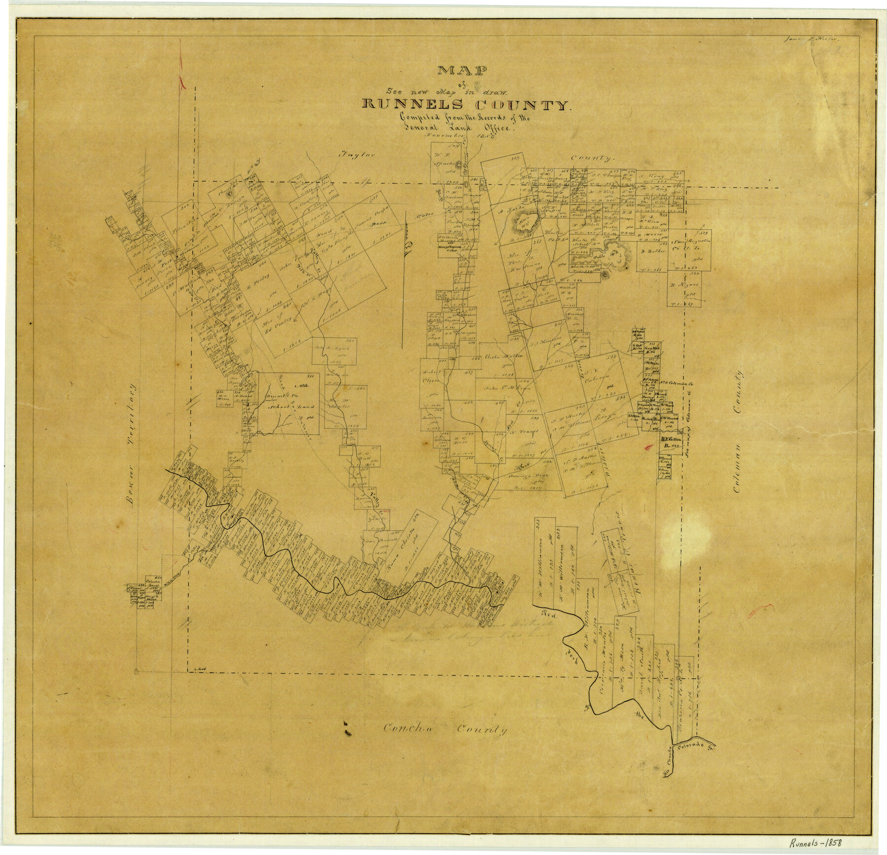
Map of Runnels County
-
Map/Doc
4004
-
Collection
General Map Collection
-
Object Dates
1858 (Creation Date)
-
People and Organizations
Texas General Land Office (Publisher)
James P. Hector (Compiler)
James P. Hector (Draftsman)
-
Counties
Runnels
-
Subjects
County
-
Height x Width
24.7 x 25.6 inches
62.7 x 65.0 cm
-
Features
Oak Creek
Road to Phantom Hill
Rio Concho
Colorado River
Red Fork of Colorado River
Mulatto Creek
Black Creek
Red Creek
Road to San Antonio
Church Mountain
Fort Chadbourne
Fish Creek
Valley Creek
Road to Fort Gates
Moro Mountain
Table Mountain
Bluff Creek
Spring Creek
Part of: General Map Collection
Reeves County Rolled Sketch N1

Print $20.00
- Digital $50.00
Reeves County Rolled Sketch N1
Size 21.8 x 41.9 inches
Map/Doc 7505
Tom Green County Boundary File 2

Print $50.00
- Digital $50.00
Tom Green County Boundary File 2
Size 14.5 x 9.0 inches
Map/Doc 59335
Hudspeth County Working Sketch 53-2

Print $40.00
- Digital $50.00
Hudspeth County Working Sketch 53-2
1988
Size 49.9 x 43.3 inches
Map/Doc 78210
Flight Mission No. DQN-1K, Frame 158, Calhoun County

Print $20.00
- Digital $50.00
Flight Mission No. DQN-1K, Frame 158, Calhoun County
1953
Size 18.6 x 22.3 inches
Map/Doc 84217
Foard County Sketch File 33

Print $26.00
- Digital $50.00
Foard County Sketch File 33
1958
Size 11.4 x 8.9 inches
Map/Doc 22866
Navarro County Rolled Sketch 4

Print $20.00
- Digital $50.00
Navarro County Rolled Sketch 4
1953
Size 27.1 x 29.8 inches
Map/Doc 6839
Kendall County Working Sketch 8

Print $20.00
- Digital $50.00
Kendall County Working Sketch 8
1951
Size 24.5 x 25.0 inches
Map/Doc 66680
Map of the Fort Worth & Denver City Ry., Dallam County, Texas

Print $40.00
- Digital $50.00
Map of the Fort Worth & Denver City Ry., Dallam County, Texas
1887
Size 21.3 x 111.8 inches
Map/Doc 64352

Foard County Sketch File 30

Print $6.00
- Digital $50.00
Foard County Sketch File 30
Size 9.1 x 8.2 inches
Map/Doc 22858
Liberty County Sketch File 20

Print $6.00
- Digital $50.00
Liberty County Sketch File 20
Size 7.8 x 9.9 inches
Map/Doc 29925
Knox County Sketch File 28

Print $20.00
- Digital $50.00
Knox County Sketch File 28
Size 43.4 x 38.3 inches
Map/Doc 10516
You may also like
Concho County Rolled Sketch 26

Print $20.00
- Digital $50.00
Concho County Rolled Sketch 26
1979
Size 15.1 x 18.1 inches
Map/Doc 5558
City of Andrews

Print $20.00
- Digital $50.00
City of Andrews
1951
Size 25.1 x 24.2 inches
Map/Doc 92454
Floyd County Sketch File 30

Print $20.00
- Digital $50.00
Floyd County Sketch File 30
Size 12.6 x 33.9 inches
Map/Doc 11489
Part of Laguna Madre in Kenedy and Willacy Counties, showing Subdivision for Mineral Development

Print $40.00
- Digital $50.00
Part of Laguna Madre in Kenedy and Willacy Counties, showing Subdivision for Mineral Development
1946
Size 49.1 x 30.0 inches
Map/Doc 1924
Texas-Oklahoma Boundary Line: brief summary of the lands surveyed and the lands not surveyed in the dispute between Oklahoma vs. Texas

Print $356.00
- Digital $50.00
Texas-Oklahoma Boundary Line: brief summary of the lands surveyed and the lands not surveyed in the dispute between Oklahoma vs. Texas
1923
Size 6.0 x 9.2 inches
Map/Doc 3061

Map of Lipscomb County

Print $20.00
- Digital $50.00
Map of Lipscomb County
1899
Size 45.1 x 39.6 inches
Map/Doc 1883
San Jacinto County Sketch File 3

Print $4.00
San Jacinto County Sketch File 3
1857
Size 10.3 x 8.1 inches
Map/Doc 35698

Flight Mission No. BQY-4M, Frame 39, Harris County

Print $20.00
- Digital $50.00
Flight Mission No. BQY-4M, Frame 39, Harris County
1953
Size 18.6 x 22.3 inches
Map/Doc 85254
Old Miscellaneous File 21

Print $16.00
- Digital $50.00
Old Miscellaneous File 21
Size 14.3 x 8.7 inches
Map/Doc 75583
Upton County Sketch File 13

Print $20.00
- Digital $50.00
Upton County Sketch File 13
1926
Size 34.3 x 37.3 inches
Map/Doc 10414