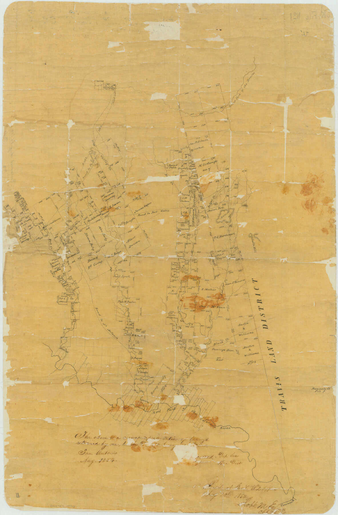
Runnels County Rolled Sketch 1
[Sketch of surveys west of the Travis Land District line, along Red Fork of the Colorado River and multiple creeks to the north]
-
Map/Doc
75941
-
Collection
General Map Collection
-
Object Dates
1854 (Creation Date)
1854/8/20 (File Date)
-
People and Organizations
F. Giraud (Surveyor/Engineer)
-
Counties
Runnels
-
Subjects
Surveying Rolled Sketch
-
Height x Width
28.0 x 18.4 inches
71.1 x 46.7 cm
-
Medium
paper, manuscript
Part of: General Map Collection
Sabine Pass and mouth of the River Sabine

Print $20.00
- Digital $50.00
Sabine Pass and mouth of the River Sabine
1840
Size 27.0 x 18.3 inches
Map/Doc 72726
Coast Chart No. 212 - From Latitude 26° 33' to the Rio Grande, Texas

Print $20.00
- Digital $50.00
Coast Chart No. 212 - From Latitude 26° 33' to the Rio Grande, Texas
1886
Size 21.9 x 17.5 inches
Map/Doc 73505
Pecos County Working Sketch 20

Print $20.00
- Digital $50.00
Pecos County Working Sketch 20
1918
Size 33.0 x 23.2 inches
Map/Doc 71490
Mills County Working Sketch 18

Print $20.00
- Digital $50.00
Mills County Working Sketch 18
1963
Size 23.2 x 37.0 inches
Map/Doc 71048
Jackson County Sketch File A2 (1)

Print $20.00
- Digital $50.00
Jackson County Sketch File A2 (1)
1899
Size 18.2 x 22.5 inches
Map/Doc 11848
Rockwall County Boundary File 4a

Print $10.00
- Digital $50.00
Rockwall County Boundary File 4a
Size 11.2 x 8.8 inches
Map/Doc 58399
Cochran County Boundary File 7

Print $6.00
- Digital $50.00
Cochran County Boundary File 7
Size 14.0 x 9.1 inches
Map/Doc 51567
Montgomery County Sketch File 35

Print $8.00
- Digital $50.00
Montgomery County Sketch File 35
1953
Size 14.1 x 8.9 inches
Map/Doc 31908
Flight Mission No. CLL-3N, Frame 41, Willacy County

Print $20.00
- Digital $50.00
Flight Mission No. CLL-3N, Frame 41, Willacy County
1954
Size 18.4 x 22.1 inches
Map/Doc 87099
Dickens County Rolled Sketch N

Print $20.00
- Digital $50.00
Dickens County Rolled Sketch N
1909
Size 21.2 x 30.6 inches
Map/Doc 5714
Flight Mission No. BQR-9K, Frame 49, Brazoria County

Print $20.00
- Digital $50.00
Flight Mission No. BQR-9K, Frame 49, Brazoria County
1952
Size 18.6 x 22.3 inches
Map/Doc 84053
Flight Mission No. CGI-3N, Frame 101, Cameron County

Print $20.00
- Digital $50.00
Flight Mission No. CGI-3N, Frame 101, Cameron County
1954
Size 18.6 x 22.1 inches
Map/Doc 84581
You may also like
Reagan County Working Sketch 13

Print $40.00
- Digital $50.00
Reagan County Working Sketch 13
1948
Size 23.8 x 50.8 inches
Map/Doc 71853

Upshur County Working Sketch 9

Print $20.00
- Digital $50.00
Upshur County Working Sketch 9
1963
Size 27.9 x 17.7 inches
Map/Doc 69565
Tyler County Boundary File 1

Print $2.00
- Digital $50.00
Tyler County Boundary File 1
Size 14.2 x 8.8 inches
Map/Doc 59494
[Topographical Map]
![92543, [Topographical Map], Twichell Survey Records](https://historictexasmaps.com/wmedia_w700/maps/92543-1.tif.jpg)
Print $20.00
- Digital $50.00
[Topographical Map]
Size 31.2 x 37.5 inches
Map/Doc 92543
Map of Callahan County

Print $20.00
- Digital $50.00
Map of Callahan County
1878
Size 23.0 x 18.8 inches
Map/Doc 3361
[Palmer and Castro Counties]
![1763, [Palmer and Castro Counties], General Map Collection](https://historictexasmaps.com/wmedia_w700/maps/1763-1.tif.jpg)
Print $20.00
- Digital $50.00
[Palmer and Castro Counties]
1910
Size 19.3 x 26.3 inches
Map/Doc 1763

Dimmit County Sketch File 21

Print $16.00
- Digital $50.00
Dimmit County Sketch File 21
1898
Size 14.4 x 8.8 inches
Map/Doc 21115
Kinney County Rolled Sketch 12

Print $20.00
- Digital $50.00
Kinney County Rolled Sketch 12
1947
Size 29.2 x 38.9 inches
Map/Doc 6541
Midland County Sketch File 13

Print $4.00
- Digital $50.00
Midland County Sketch File 13
1940
Size 11.2 x 8.7 inches
Map/Doc 31576
Sterling County Rolled Sketch 30

Print $20.00
- Digital $50.00
Sterling County Rolled Sketch 30
Size 20.4 x 27.8 inches
Map/Doc 7855