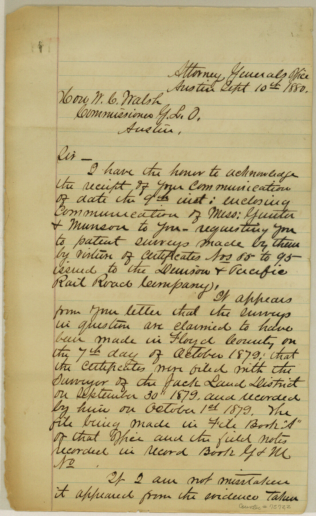
Old Miscellaneous File 27b
AG Opinion regarding surveys in Panhandle made by Jack County District Surveyor
-
Map/Doc
75722
-
Collection
General Map Collection
-
Object Dates
1880/9/10 (Creation Date)
1880/9/11 (File Date)
-
Subjects
District Legal
-
Height x Width
14.3 x 8.8 inches
36.3 x 22.4 cm
Part of: General Map Collection
Outer Continental Shelf Leasing Maps (Louisiana Offshore Operations)

Print $20.00
- Digital $50.00
Outer Continental Shelf Leasing Maps (Louisiana Offshore Operations)
1959
Size 17.9 x 13.8 inches
Map/Doc 76101
Terry County Sketch File 5

Print $40.00
- Digital $50.00
Terry County Sketch File 5
1916
Size 15.6 x 58.6 inches
Map/Doc 10391
Henderson County Sketch File 7

Print $4.00
- Digital $50.00
Henderson County Sketch File 7
1854
Size 8.6 x 8.6 inches
Map/Doc 26329
Photo Index of Texas Coast - Sheet 3 of 6

Print $20.00
- Digital $50.00
Photo Index of Texas Coast - Sheet 3 of 6
1954
Size 20.0 x 24.0 inches
Map/Doc 83441
Van Zandt County Working Sketch 14

Print $20.00
- Digital $50.00
Van Zandt County Working Sketch 14
1982
Size 13.2 x 11.5 inches
Map/Doc 72264
Grayson County Working Sketch 12

Print $20.00
- Digital $50.00
Grayson County Working Sketch 12
1951
Size 25.7 x 24.0 inches
Map/Doc 63251
Flight Mission No. CUG-3P, Frame 141, Kleberg County

Print $20.00
- Digital $50.00
Flight Mission No. CUG-3P, Frame 141, Kleberg County
1956
Size 18.4 x 22.2 inches
Map/Doc 86276
[Sketch for Mineral Application 36425 - Jefferson County, Ley C. Moore]
![65616, [Sketch for Mineral Application 36425 - Jefferson County, Ley C. Moore], General Map Collection](https://historictexasmaps.com/wmedia_w700/maps/65616.tif.jpg)
Print $40.00
- Digital $50.00
[Sketch for Mineral Application 36425 - Jefferson County, Ley C. Moore]
1942
Size 49.2 x 35.0 inches
Map/Doc 65616
Comal County Working Sketch 12

Print $20.00
- Digital $50.00
Comal County Working Sketch 12
1987
Size 31.1 x 29.6 inches
Map/Doc 68178
Flight Mission No. BQR-20K, Frame 15, Brazoria County

Print $20.00
- Digital $50.00
Flight Mission No. BQR-20K, Frame 15, Brazoria County
1952
Size 18.6 x 22.3 inches
Map/Doc 84117
Cass County Working Sketch 37

Print $20.00
- Digital $50.00
Cass County Working Sketch 37
1982
Size 26.8 x 31.8 inches
Map/Doc 67940
Flight Mission No. BQY-15M, Frame 10, Harris County

Print $20.00
- Digital $50.00
Flight Mission No. BQY-15M, Frame 10, Harris County
1953
Size 18.5 x 22.3 inches
Map/Doc 85308
You may also like
Flight Mission No. DIX-6P, Frame 196, Aransas County

Print $20.00
- Digital $50.00
Flight Mission No. DIX-6P, Frame 196, Aransas County
1956
Size 18.9 x 22.6 inches
Map/Doc 83858
[Blocks 5-T, M-23, and vicinity]
![91230, [Blocks 5-T, M-23, and vicinity], Twichell Survey Records](https://historictexasmaps.com/wmedia_w700/maps/91230-1.tif.jpg)
Print $20.00
- Digital $50.00
[Blocks 5-T, M-23, and vicinity]
1890
Size 39.0 x 22.7 inches
Map/Doc 91230
[Sketch of Runnels County School Land and vicinity]
![91666, [Sketch of Runnels County School Land and vicinity], Twichell Survey Records](https://historictexasmaps.com/wmedia_w700/maps/91666-1.tif.jpg)
Print $20.00
- Digital $50.00
[Sketch of Runnels County School Land and vicinity]
Size 17.3 x 15.3 inches
Map/Doc 91666
Flight Mission No. BRA-7M, Frame 148, Jefferson County

Print $20.00
- Digital $50.00
Flight Mission No. BRA-7M, Frame 148, Jefferson County
1953
Size 18.6 x 22.4 inches
Map/Doc 85542
Presidio County Working Sketch 132

Print $20.00
- Digital $50.00
Presidio County Working Sketch 132
1989
Size 36.7 x 29.4 inches
Map/Doc 71810
Flight Mission No. BRA-16M, Frame 129, Jefferson County

Print $20.00
- Digital $50.00
Flight Mission No. BRA-16M, Frame 129, Jefferson County
1953
Size 18.4 x 22.7 inches
Map/Doc 85739
Fractional Township No. 9 South Range No. 11 East of the Indian Meridian, Indian Territory

Print $20.00
- Digital $50.00
Fractional Township No. 9 South Range No. 11 East of the Indian Meridian, Indian Territory
1898
Size 19.3 x 24.4 inches
Map/Doc 75220
Travis County

Print $40.00
- Digital $50.00
Travis County
1936
Size 47.0 x 53.7 inches
Map/Doc 73305

Van Zandt County

Print $20.00
- Digital $50.00
Van Zandt County
1870
Size 22.9 x 21.6 inches
Map/Doc 4637
Harris County Historic Topographic 22

Print $20.00
- Digital $50.00
Harris County Historic Topographic 22
1915
Size 29.2 x 22.7 inches
Map/Doc 65833
Flight Mission No. DAG-17K, Frame 119, Matagorda County

Print $20.00
- Digital $50.00
Flight Mission No. DAG-17K, Frame 119, Matagorda County
1952
Size 16.4 x 16.5 inches
Map/Doc 86339