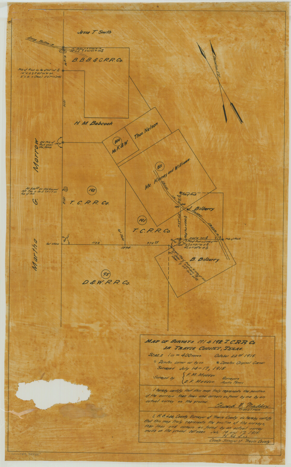
Map of surveys 191 & 192 T. C. R.R. Co. in Travis County, Texas
-
Map/Doc
75555
-
Collection
Maddox Collection
-
Object Dates
1915/10/22 (Creation Date)
1915/7/14 (Survey Date)
-
People and Organizations
H.G. Lee (Surveyor/Engineer)
E.F. Maddox (Draftsman)
Edward F. Maddox (Surveyor/Engineer)
F.M. Maddox (Surveyor/Engineer)
-
Counties
Travis
-
Height x Width
20.7 x 12.9 inches
52.6 x 32.8 cm
-
Medium
paper, manuscript
-
Scale
1 in = 400 varas
-
Features
Cross Creek
Long Hollow
Sandy Creek
Part of: Maddox Collection
Map of the C.C. Browning survey 412 enlarged from General Land Office map of the west part of Travis County, Texas

Print $3.00
- Digital $50.00
Map of the C.C. Browning survey 412 enlarged from General Land Office map of the west part of Travis County, Texas
1920
Size 11.3 x 9.1 inches
Map/Doc 10752
Trinity County, Texas

Print $20.00
- Digital $50.00
Trinity County, Texas
1882
Size 20.3 x 17.4 inches
Map/Doc 485
Bastrop County

Print $20.00
- Digital $50.00
Bastrop County
1879
Size 27.1 x 26.1 inches
Map/Doc 692
Subdivision of the East Half of Lot No. 1 in Division "Z" of the Out-Lots adjoining the City of Austin

Print $20.00
- Digital $50.00
Subdivision of the East Half of Lot No. 1 in Division "Z" of the Out-Lots adjoining the City of Austin
Size 32.1 x 42.6 inches
Map/Doc 648
Motley County, Texas

Print $20.00
- Digital $50.00
Motley County, Texas
1883
Size 23.6 x 20.7 inches
Map/Doc 743
Graham's Addition Being a Subdivision of a Portion of Lot No. 1 of Spear League

Print $20.00
- Digital $50.00
Graham's Addition Being a Subdivision of a Portion of Lot No. 1 of Spear League
1914
Size 33.2 x 13.6 inches
Map/Doc 83426
Map of Public Land on Mustang Island

Print $20.00
- Digital $50.00
Map of Public Land on Mustang Island
Size 21.9 x 17.5 inches
Map/Doc 82315
Ochiltree County, Texas

Print $20.00
- Digital $50.00
Ochiltree County, Texas
1870
Size 21.4 x 19.7 inches
Map/Doc 507
[Map Showing Surveys in Dimmit & La Salle Counties, Texas]
![75792, [Map Showing Surveys in Dimmit & La Salle Counties, Texas], Maddox Collection](https://historictexasmaps.com/wmedia_w700/maps/75792.tif.jpg)
Print $20.00
- Digital $50.00
[Map Showing Surveys in Dimmit & La Salle Counties, Texas]
1882
Size 32.6 x 28.7 inches
Map/Doc 75792
Map of the north west portion of Hutchinson County showing the proposed resurvey of Block M24

Print $20.00
- Digital $50.00
Map of the north west portion of Hutchinson County showing the proposed resurvey of Block M24
Size 29.1 x 31.9 inches
Map/Doc 75814
Map Showing the position of surveys 1 & 2, B.S. & F. Cert 1/356

Print $20.00
- Digital $50.00
Map Showing the position of surveys 1 & 2, B.S. & F. Cert 1/356
1915
Size 22.0 x 11.1 inches
Map/Doc 10768
Map of Denton County, Texas

Print $20.00
- Digital $50.00
Map of Denton County, Texas
Size 22.8 x 19.4 inches
Map/Doc 711
You may also like
Wichita County Sketch File 10

Print $4.00
- Digital $50.00
Wichita County Sketch File 10
Size 12.7 x 8.3 inches
Map/Doc 40054
Callahan County

Print $20.00
- Digital $50.00
Callahan County
1918
Size 45.3 x 41.0 inches
Map/Doc 66743
Real County Rolled Sketch 18

Print $20.00
- Digital $50.00
Real County Rolled Sketch 18
Size 22.0 x 28.0 inches
Map/Doc 7463
Hudspeth County Sketch File 25

Print $10.00
- Digital $50.00
Hudspeth County Sketch File 25
1936
Size 11.3 x 8.7 inches
Map/Doc 26979

Kinney County Working Sketch 27

Print $20.00
- Digital $50.00
Kinney County Working Sketch 27
1956
Size 23.1 x 25.1 inches
Map/Doc 70209
Comanche County Rolled Sketch 2

Print $40.00
- Digital $50.00
Comanche County Rolled Sketch 2
1989
Size 36.9 x 48.6 inches
Map/Doc 10299
Parker County Sketch File 40

Print $4.00
- Digital $50.00
Parker County Sketch File 40
Size 8.1 x 12.7 inches
Map/Doc 33585
Index for Texas Railroad ROW & track maps available on microfilm at THD & Archives and Records

Print $2.00
- Digital $50.00
Index for Texas Railroad ROW & track maps available on microfilm at THD & Archives and Records
1977
Size 11.1 x 8.9 inches
Map/Doc 60755
Austin Empresario Colony. March 27, 1827

Print $20.00
Austin Empresario Colony. March 27, 1827
2020
Size 18.0 x 21.6 inches
Map/Doc 95980
Brazoria County Sketch File 1a

Print $6.00
- Digital $50.00
Brazoria County Sketch File 1a
1861
Size 12.5 x 11.5 inches
Map/Doc 14918
Williamson County

Print $40.00
- Digital $50.00
Williamson County
1946
Size 39.0 x 56.3 inches
Map/Doc 73326