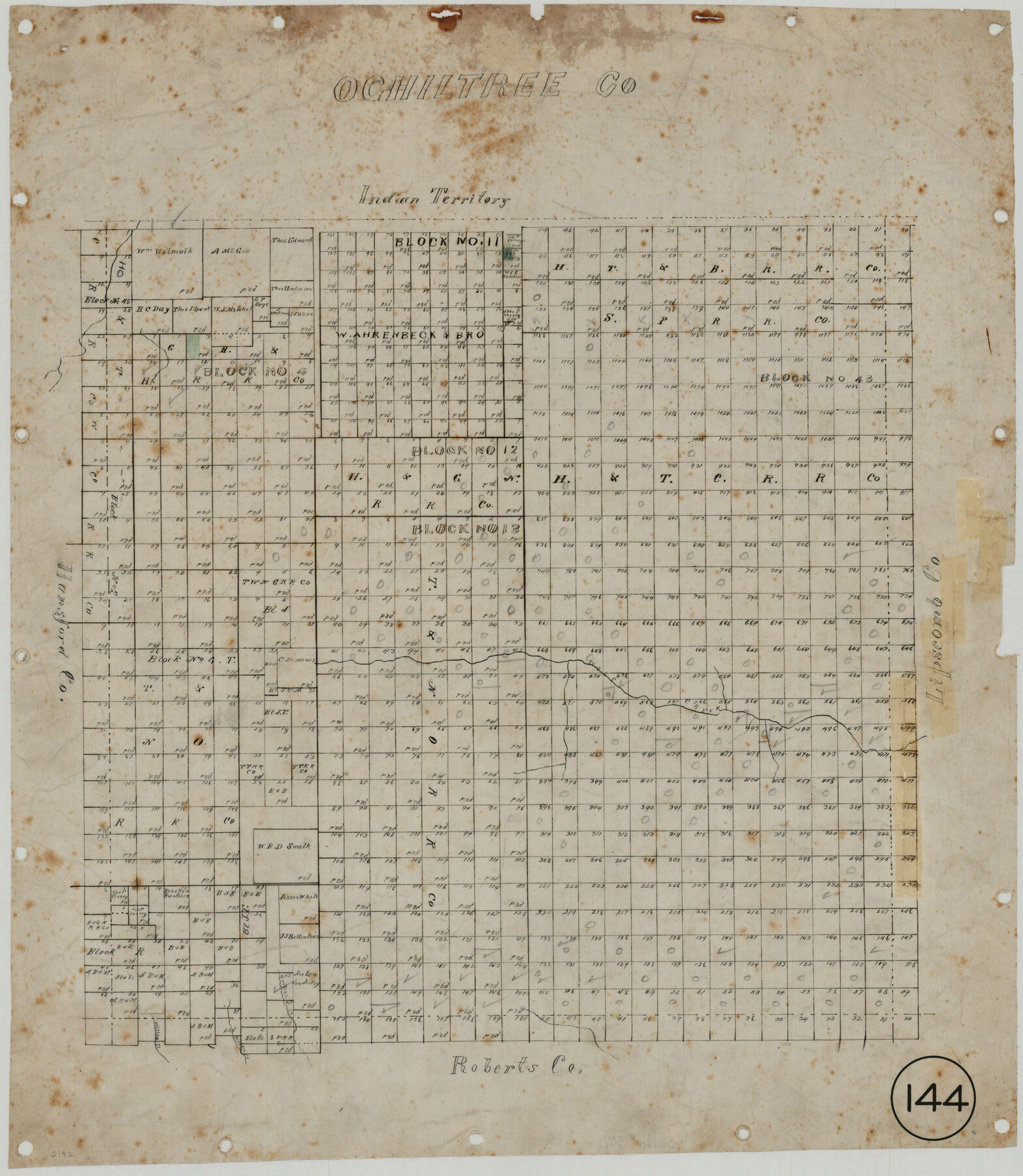
Ochiltree County, Texas
-
Map/Doc
507
-
Collection
Maddox Collection
-
Object Dates
[1870 ca.] (Creation Date)
-
Counties
Ochiltree
-
Subjects
County
-
Height x Width
21.4 x 19.7 inches
54.4 x 50.0 cm
-
Medium
linen, manuscript
-
Comments
Conservation funded in 2011 by Friends of the Texas General Land Office.
-
Features
Indian Territory
Wolf Creek
Martins Creek
Walker Creek
Willow Creek
Part of: Maddox Collection
Marion County, Texas

Print $20.00
- Digital $50.00
Marion County, Texas
1879
Size 15.0 x 20.7 inches
Map/Doc 651
Tarrant County, Texas

Print $20.00
- Digital $50.00
Tarrant County, Texas
1870
Size 24.1 x 19.1 inches
Map/Doc 758
Leon County, Texas

Print $20.00
- Digital $50.00
Leon County, Texas
1879
Size 25.6 x 22.3 inches
Map/Doc 563
Survey of a Portion of Lot. No. 1 of Spear League

Print $20.00
- Digital $50.00
Survey of a Portion of Lot. No. 1 of Spear League
1911
Size 12.2 x 24.2 inches
Map/Doc 477
Red River County, Texas

Print $20.00
- Digital $50.00
Red River County, Texas
1870
Size 23.2 x 18.7 inches
Map/Doc 748
Lands of Gunter & Munson and Maddox Bros. & Anderson, Tom Green Co. Tex.

Print $20.00
- Digital $50.00
Lands of Gunter & Munson and Maddox Bros. & Anderson, Tom Green Co. Tex.
Size 20.4 x 30.7 inches
Map/Doc 75787
Tracing from a map of Swisher Subdivision of part of the Isaac Decker league southside Colorado River an addition to the City of Austin

Print $20.00
- Digital $50.00
Tracing from a map of Swisher Subdivision of part of the Isaac Decker league southside Colorado River an addition to the City of Austin
1877
Size 24.0 x 14.6 inches
Map/Doc 455
Map of Survey 10, Block 1, D.B. Gardner

Print $20.00
- Digital $50.00
Map of Survey 10, Block 1, D.B. Gardner
1915
Size 16.1 x 18.7 inches
Map/Doc 10764
Part of Tom Green County, Texas (No. 1)

Print $20.00
- Digital $50.00
Part of Tom Green County, Texas (No. 1)
1870
Size 22.8 x 17.7 inches
Map/Doc 759
City of Austin, Texas Use District Map

Print $20.00
- Digital $50.00
City of Austin, Texas Use District Map
1939
Size 42.9 x 32.2 inches
Map/Doc 452
Skeleton Map of Nueces County

Print $20.00
- Digital $50.00
Skeleton Map of Nueces County
1907
Size 32.4 x 37.3 inches
Map/Doc 593
Sketch showing position of Asylum Lands Blk. 4, H. & T. C. R.R. Co. & river surveys on north side of Middle Concho, Tom Green Co.

Print $20.00
- Digital $50.00
Sketch showing position of Asylum Lands Blk. 4, H. & T. C. R.R. Co. & river surveys on north side of Middle Concho, Tom Green Co.
Size 14.4 x 20.6 inches
Map/Doc 388
You may also like
From Citizens of Shelby and Red River Counties Living East of the Sabine River and Southwest of the Sulphur Fork of Red River for the Creation of a New County to be Called Green, March 11, 1837/April 1, 1837

Print $20.00
From Citizens of Shelby and Red River Counties Living East of the Sabine River and Southwest of the Sulphur Fork of Red River for the Creation of a New County to be Called Green, March 11, 1837/April 1, 1837
2020
Size 24.3 x 21.7 inches
Map/Doc 96373
Blanco County Sketch File 9

Print $4.00
- Digital $50.00
Blanco County Sketch File 9
Size 6.9 x 13.9 inches
Map/Doc 14586
Cochran County Boundary File 7

Print $6.00
- Digital $50.00
Cochran County Boundary File 7
Size 14.0 x 9.1 inches
Map/Doc 51567
Clay County Boundary File 9

Print $8.00
- Digital $50.00
Clay County Boundary File 9
Size 7.7 x 8.2 inches
Map/Doc 51393
Presidio County Rolled Sketch 86

Print $20.00
- Digital $50.00
Presidio County Rolled Sketch 86
1945
Size 34.1 x 27.8 inches
Map/Doc 7372
Nacogdoches County Working Sketch 9

Print $20.00
- Digital $50.00
Nacogdoches County Working Sketch 9
1967
Size 27.6 x 32.1 inches
Map/Doc 71225
Bee County Working Sketch 1

Print $20.00
- Digital $50.00
Bee County Working Sketch 1
Size 23.2 x 40.4 inches
Map/Doc 67251
Concho County Sketch File 18

Print $32.00
- Digital $50.00
Concho County Sketch File 18
1898
Size 9.1 x 4.4 inches
Map/Doc 19137
Terrell County Working Sketch 58

Print $40.00
- Digital $50.00
Terrell County Working Sketch 58
1960
Size 36.3 x 48.9 inches
Map/Doc 69579
Real County Sketch File 19

Print $22.00
- Digital $50.00
Real County Sketch File 19
1967
Size 11.5 x 9.0 inches
Map/Doc 35080
Howard County

Print $20.00
- Digital $50.00
Howard County
1922
Size 42.3 x 36.2 inches
Map/Doc 95535
Sterling County Working Sketch Graphic Index

Print $20.00
- Digital $50.00
Sterling County Working Sketch Graphic Index
1971
Size 45.5 x 36.3 inches
Map/Doc 76703