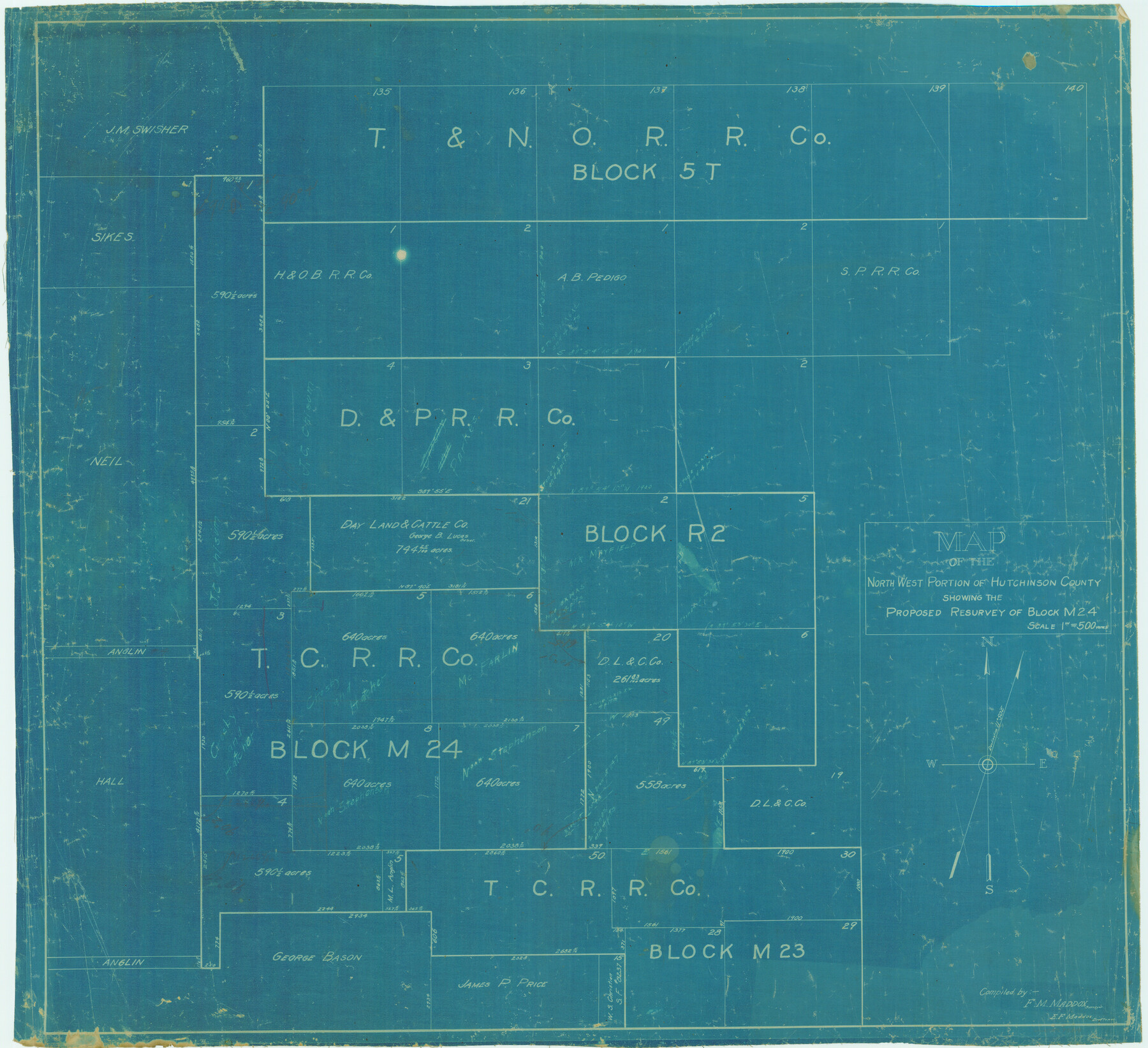
Map of the north west portion of Hutchinson County showing the proposed resurvey of Block M24
-
Map/Doc
75814
-
Collection
Maddox Collection
-
People and Organizations
F.M. Maddox (Surveyor/Engineer)
E.F. Maddox (Draftsman)
F.M. Maddox (Compiler)
-
Counties
Hudspeth
-
Height x Width
29.1 x 31.9 inches
73.9 x 81.0 cm
-
Medium
blueprint/diazo
-
Scale
1" = 500 varas
Part of: Maddox Collection
Revised Sectional Map No. 4 showing land surveys in the western portion of the county of El Paso, Texas

Print $20.00
- Digital $50.00
Revised Sectional Map No. 4 showing land surveys in the western portion of the county of El Paso, Texas
Size 19.0 x 24.2 inches
Map/Doc 4477
Map of Galveston County, Texas

Print $20.00
- Digital $50.00
Map of Galveston County, Texas
1879
Size 18.3 x 26.6 inches
Map/Doc 546
Free & Williams Subdivision of the north half of Outlots 56 and 57

Print $20.00
- Digital $50.00
Free & Williams Subdivision of the north half of Outlots 56 and 57
Size 10.9 x 29.5 inches
Map/Doc 475
Map of Jefferson County, Texas

Print $20.00
- Digital $50.00
Map of Jefferson County, Texas
1879
Size 23.2 x 20.6 inches
Map/Doc 5054
Red River County, Texas

Print $20.00
- Digital $50.00
Red River County, Texas
1870
Size 23.2 x 18.7 inches
Map/Doc 748
Sketch of Surveys in Knox County

Print $20.00
- Digital $50.00
Sketch of Surveys in Knox County
1896
Size 17.6 x 31.2 inches
Map/Doc 75788
Map of survey made for Ingham S. Roberts on Application No. 147, SF-9177 containing 413.78 acres, 4 mi SE of Houston, Harris Co. Texas

Print $20.00
- Digital $50.00
Map of survey made for Ingham S. Roberts on Application No. 147, SF-9177 containing 413.78 acres, 4 mi SE of Houston, Harris Co. Texas
1910
Size 37.3 x 31.0 inches
Map/Doc 373
[Sketch of Pecos County School Land surveys along Pecos River in Val Verde County]
![369, [Sketch of Pecos County School Land surveys along Pecos River in Val Verde County], Maddox Collection](https://historictexasmaps.com/wmedia_w700/maps/0369-1.tif.jpg)
Print $2.00
- Digital $50.00
[Sketch of Pecos County School Land surveys along Pecos River in Val Verde County]
1882
Size 10.2 x 8.9 inches
Map/Doc 369
Plat of a portion of Buchel County, Texas

Print $20.00
- Digital $50.00
Plat of a portion of Buchel County, Texas
Size 16.0 x 26.2 inches
Map/Doc 82526
Map of Tyler County, Texas

Print $20.00
- Digital $50.00
Map of Tyler County, Texas
1881
Size 22.3 x 24.2 inches
Map/Doc 762
[Northern Portion of] Cottle County
![4436, [Northern Portion of] Cottle County, Maddox Collection](https://historictexasmaps.com/wmedia_w700/maps/4436.tif.jpg)
Print $20.00
- Digital $50.00
[Northern Portion of] Cottle County
1908
Size 28.4 x 29.5 inches
Map/Doc 4436
Saline Ranch in Mason, Kimble and Menard Counties

Print $20.00
- Digital $50.00
Saline Ranch in Mason, Kimble and Menard Counties
1916
Size 28.6 x 27.4 inches
Map/Doc 75808
You may also like
Randall County

Print $20.00
- Digital $50.00
Randall County
1958
Size 46.2 x 39.9 inches
Map/Doc 95620
Map of that part of the boundary between the Republic of Texas and the United States, comprised between Logan's Ferry on the Sabine River and the 36th Mile Mound on the Meridian Line (Sheet No. 1)
![4671, Map of that part of the boundary between the Republic of Texas and the United States, comprised between Logan's Ferry on the Sabine River and the [3]6th Mile Mound on the [Meridian Line] (Sheet No. 1), General Map Collection](https://historictexasmaps.com/wmedia_w700/maps/4671-GC.tif.jpg)
Print $20.00
- Digital $50.00
Map of that part of the boundary between the Republic of Texas and the United States, comprised between Logan's Ferry on the Sabine River and the 36th Mile Mound on the Meridian Line (Sheet No. 1)
1842
Size 34.6 x 26.4 inches
Map/Doc 4671
[Neches River Bed, Plat and Calculations]
![2466, [Neches River Bed, Plat and Calculations], General Map Collection](https://historictexasmaps.com/wmedia_w700/maps/2466-GC.tif.jpg)
Print $40.00
- Digital $50.00
[Neches River Bed, Plat and Calculations]
1928
Size 27.3 x 51.0 inches
Map/Doc 2466
La Salle County Working Sketch 39

Print $20.00
- Digital $50.00
La Salle County Working Sketch 39
1963
Size 30.4 x 25.4 inches
Map/Doc 70340
Property Line Map, Low Rent Housing Project Texas 18-1, Housing Authority of the City of Lubbock

Print $20.00
- Digital $50.00
Property Line Map, Low Rent Housing Project Texas 18-1, Housing Authority of the City of Lubbock
1941
Size 42.2 x 27.9 inches
Map/Doc 92753
Leon County Sketch File 6

Print $4.00
- Digital $50.00
Leon County Sketch File 6
1859
Size 8.2 x 12.0 inches
Map/Doc 29719
Kleberg County NRC Article 33.136 Sketch 1

Print $143.00
- Digital $50.00
Kleberg County NRC Article 33.136 Sketch 1
2000
Size 18.5 x 23.6 inches
Map/Doc 6555
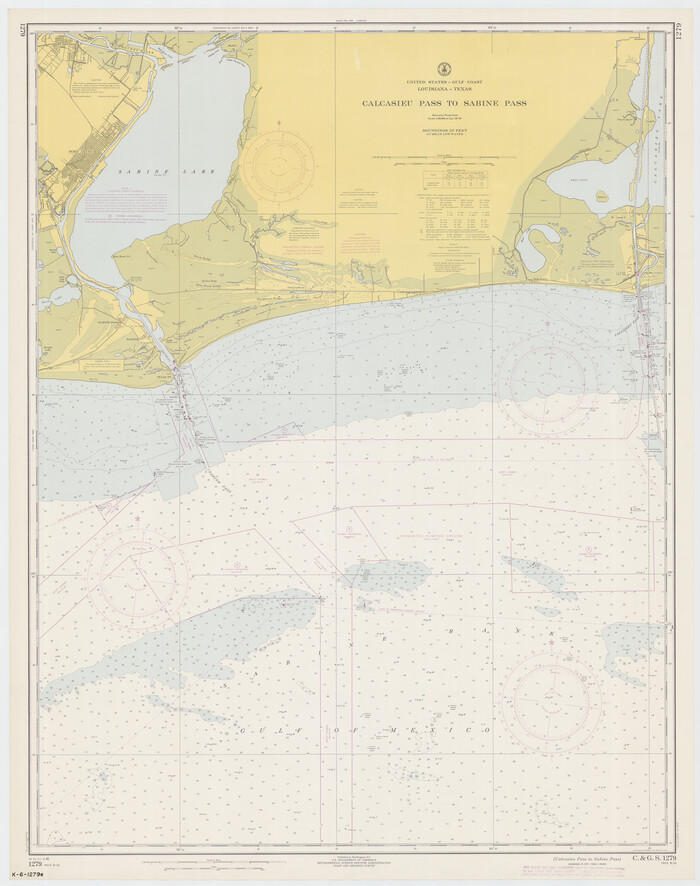
Calcasieu Pass to Sabine Pass
Print $20.00
- Digital $50.00
Calcasieu Pass to Sabine Pass
1966
Size 44.9 x 35.5 inches
Map/Doc 69810
Dickens County, Texas

Print $20.00
- Digital $50.00
Dickens County, Texas
1891
Size 24.5 x 20.4 inches
Map/Doc 707
Montgomery County Rolled Sketch 42

Print $20.00
- Digital $50.00
Montgomery County Rolled Sketch 42
1939
Size 14.2 x 20.5 inches
Map/Doc 6817
Map of Burleson County

Print $20.00
- Digital $50.00
Map of Burleson County
1856
Size 22.0 x 31.5 inches
Map/Doc 3345
[Sketch showing T. &P. R. R. Co. Blks. 32, 33, 34 Township 4N, and J. Poitevent Block I]
![89629, [Sketch showing T. &P. R. R. Co. Blks. 32, 33, 34 Township 4N, and J. Poitevent Block I], Twichell Survey Records](https://historictexasmaps.com/wmedia_w700/maps/89629-1.tif.jpg)
Print $40.00
- Digital $50.00
[Sketch showing T. &P. R. R. Co. Blks. 32, 33, 34 Township 4N, and J. Poitevent Block I]
Size 19.2 x 49.8 inches
Map/Doc 89629