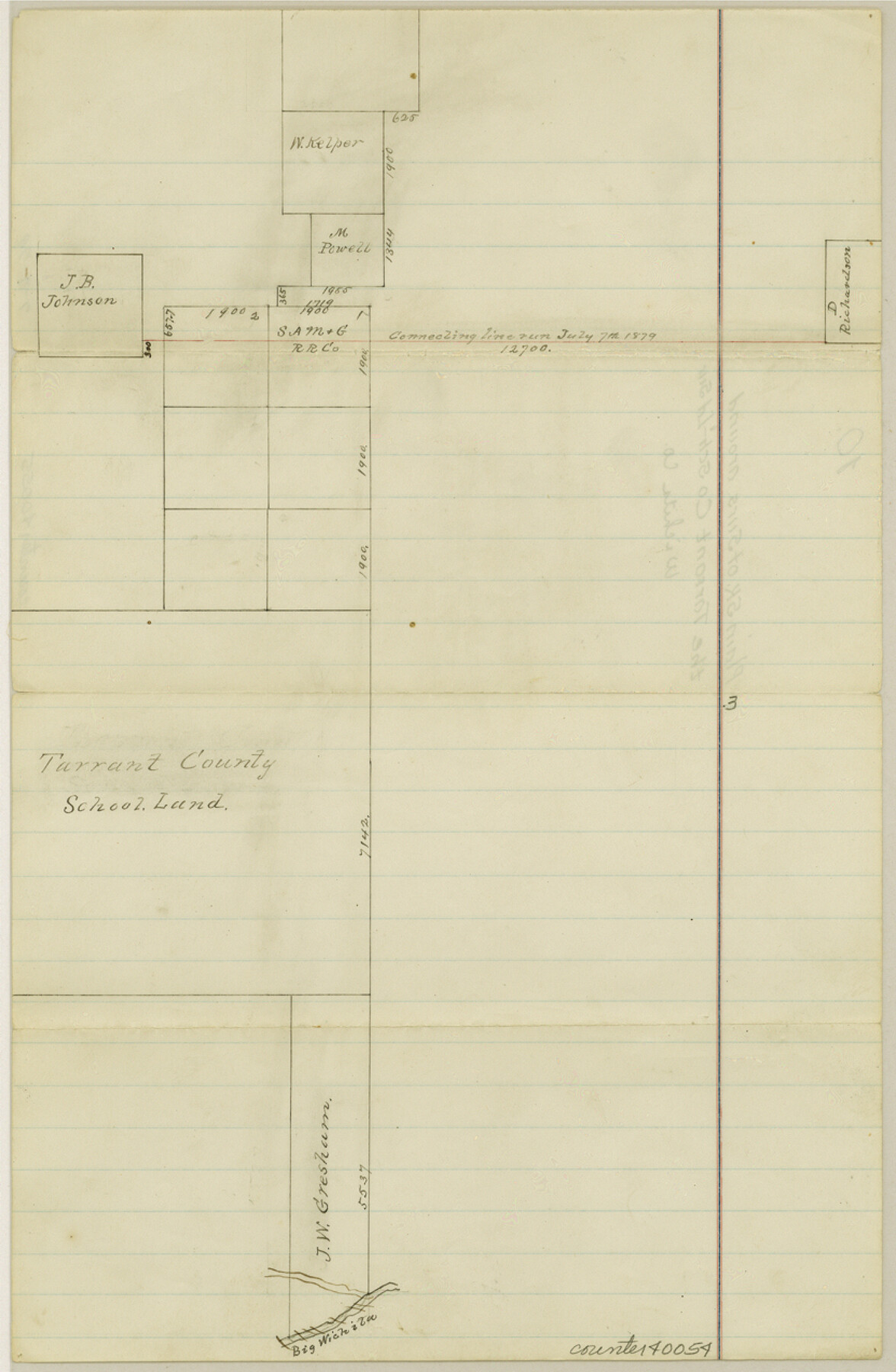
Wichita County Sketch File 10
[Sketch of surveys around the Tarrant County School Land survey west of Wichita Falls]
-
Map/Doc
40054
-
Collection
General Map Collection
-
Counties
Wichita
-
Subjects
Surveying Sketch File
-
Height x Width
12.7 x 8.3 inches
32.3 x 21.1 cm
-
Medium
paper, manuscript
-
Features
Big Wichita River
Part of: General Map Collection
Frio County Working Sketch 12

Print $40.00
- Digital $50.00
Frio County Working Sketch 12
1953
Size 52.8 x 39.9 inches
Map/Doc 69286
Lampasas County Sketch File 7

Print $4.00
- Digital $50.00
Lampasas County Sketch File 7
1871
Size 8.4 x 8.2 inches
Map/Doc 29402
San Saba County Boundary File 77

Print $32.00
- Digital $50.00
San Saba County Boundary File 77
Size 9.2 x 7.7 inches
Map/Doc 58577
Sutton County Working Sketch 12

Print $40.00
- Digital $50.00
Sutton County Working Sketch 12
1972
Size 66.8 x 37.3 inches
Map/Doc 62355
Hudspeth County Working Sketch 42

Print $20.00
- Digital $50.00
Hudspeth County Working Sketch 42
1981
Size 34.2 x 36.5 inches
Map/Doc 66327
[Map of a portion of Bexar and Travis Districts]
![16943, [Map of a portion of Bexar and Travis Districts], General Map Collection](https://historictexasmaps.com/wmedia_w700/maps/16943.tif.jpg)
Print $20.00
- Digital $50.00
[Map of a portion of Bexar and Travis Districts]
Size 47.5 x 47.2 inches
Map/Doc 16943
Calcasieu Pass to Sabine Pass

Print $20.00
- Digital $50.00
Calcasieu Pass to Sabine Pass
1946
Size 45.0 x 35.7 inches
Map/Doc 69807
Terry County Sketch File 3

Print $20.00
- Digital $50.00
Terry County Sketch File 3
1948
Size 16.2 x 39.0 inches
Map/Doc 10390
Flight Mission No. DQN-2K, Frame 7, Calhoun County

Print $20.00
- Digital $50.00
Flight Mission No. DQN-2K, Frame 7, Calhoun County
1953
Size 18.4 x 22.1 inches
Map/Doc 84224
Burnet County Sketch File 42

Print $28.00
- Digital $50.00
Burnet County Sketch File 42
1950
Size 9.9 x 8.8 inches
Map/Doc 16760
Hamilton County Working Sketch 17

Print $20.00
- Digital $50.00
Hamilton County Working Sketch 17
1951
Size 44.4 x 25.0 inches
Map/Doc 63355
Andrews County Rolled Sketch 45

Print $40.00
- Digital $50.00
Andrews County Rolled Sketch 45
1946
Size 111.7 x 41.0 inches
Map/Doc 8402
You may also like
Map of the State of Texas Showing Original Land Districts

Print $20.00
- Digital $50.00
Map of the State of Texas Showing Original Land Districts
1891
Size 45.6 x 43.0 inches
Map/Doc 1995
Right of Way and Track Map of The Missouri, Kansas & Texas Railway of Texas

Print $40.00
- Digital $50.00
Right of Way and Track Map of The Missouri, Kansas & Texas Railway of Texas
1918
Size 25.9 x 108.3 inches
Map/Doc 64526
Medina County Sketch File 8

Print $4.00
- Digital $50.00
Medina County Sketch File 8
Size 9.3 x 6.6 inches
Map/Doc 31456
Flight Mission No. CRC-2R, Frame 132, Chambers County

Print $20.00
- Digital $50.00
Flight Mission No. CRC-2R, Frame 132, Chambers County
1956
Size 18.6 x 22.3 inches
Map/Doc 84748

Subdivision Map, Calhoun County School Land Leagues 1-4, Located in Hale and Floyd Counties

Print $20.00
- Digital $50.00
Subdivision Map, Calhoun County School Land Leagues 1-4, Located in Hale and Floyd Counties
Size 28.1 x 31.5 inches
Map/Doc 92660
Haskell County Sketch File 4

Print $20.00
- Digital $50.00
Haskell County Sketch File 4
Size 17.7 x 18.6 inches
Map/Doc 11739
Map of the United States and Texas Boundary Line and adjacent territory determined & surveyed in 1857-8-9-60 by J.H. Clark, U.S. Commissioner, &ca. &ca. under the direction of the Departement [sic] of the Interior
![94063, Map of the United States and Texas Boundary Line and adjacent territory determined & surveyed in 1857-8-9-60 by J.H. Clark, U.S. Commissioner, &ca. &ca. under the direction of the Departement [sic] of the Interior, General Map Collection](https://historictexasmaps.com/wmedia_w700/maps/94063.tif.jpg)
Print $20.00
- Digital $50.00
Map of the United States and Texas Boundary Line and adjacent territory determined & surveyed in 1857-8-9-60 by J.H. Clark, U.S. Commissioner, &ca. &ca. under the direction of the Departement [sic] of the Interior
1902
Size 27.9 x 41.8 inches
Map/Doc 94063
Waller County Working Sketch 6

Print $20.00
- Digital $50.00
Waller County Working Sketch 6
1988
Size 31.1 x 20.0 inches
Map/Doc 72305
[Galveston, Harrisburg & San Antonio Railroad from Cuero to Stockdale]
![64185, [Galveston, Harrisburg & San Antonio Railroad from Cuero to Stockdale], General Map Collection](https://historictexasmaps.com/wmedia_w700/maps/64185.tif.jpg)
Print $20.00
- Digital $50.00
[Galveston, Harrisburg & San Antonio Railroad from Cuero to Stockdale]
1906
Size 13.6 x 34.0 inches
Map/Doc 64185
Kaufman County Sketch File 10

Print $4.00
- Digital $50.00
Kaufman County Sketch File 10
1873
Size 10.2 x 8.2 inches
Map/Doc 28643
[Surveys in Austin's Colony along the San Antonio Road and the Brazos and Yegua Rivers]
![203, [Surveys in Austin's Colony along the San Antonio Road and the Brazos and Yegua Rivers], General Map Collection](https://historictexasmaps.com/wmedia_w700/maps/203.tif.jpg)
Print $20.00
- Digital $50.00
[Surveys in Austin's Colony along the San Antonio Road and the Brazos and Yegua Rivers]
1831
Size 30.8 x 19.1 inches
Map/Doc 203