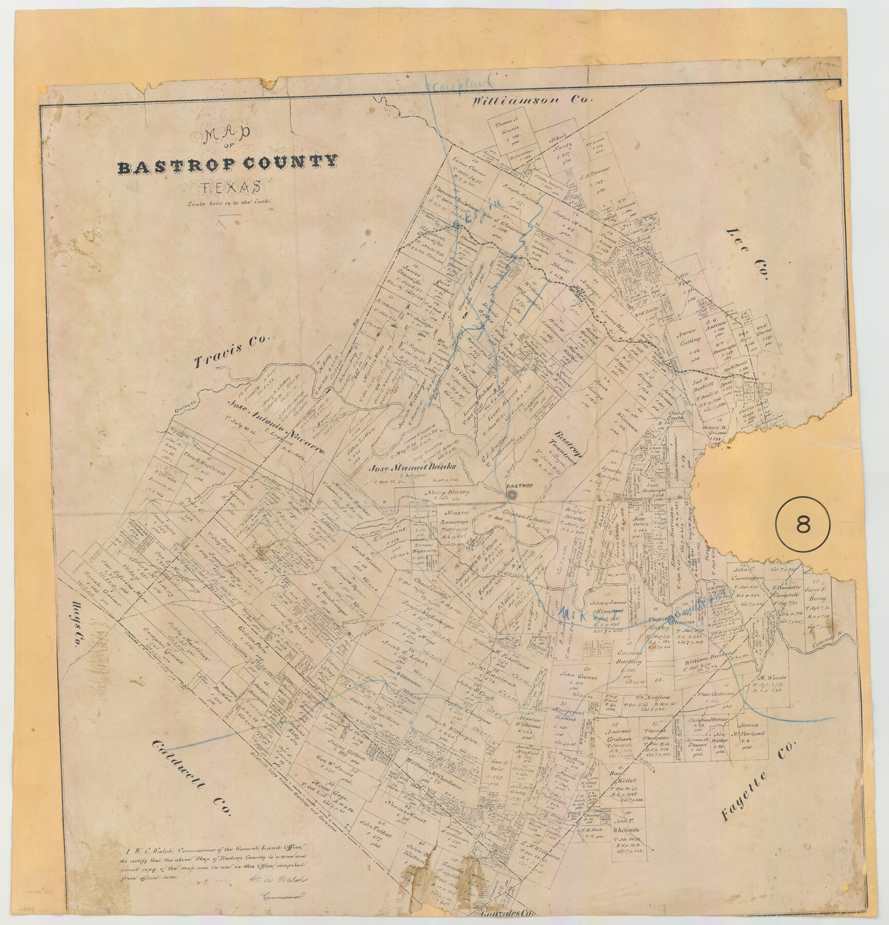
Bastrop County
-
Map/Doc
692
-
Collection
Maddox Collection
-
Object Dates
1879 (Creation Date)
-
Counties
Bastrop
-
Subjects
County
-
Height x Width
27.1 x 26.1 inches
68.8 x 66.3 cm
-
Comments
Adopted with contributions from the 2010 State Employee Charitable Campaign (SECC).
Part of: Maddox Collection
Borden County, Texas

Print $20.00
- Digital $50.00
Borden County, Texas
1887
Size 19.9 x 18.3 inches
Map/Doc 596
Working Sketch of surveys in Mason, Kimble & Menard Counties

Print $20.00
- Digital $50.00
Working Sketch of surveys in Mason, Kimble & Menard Counties
1900
Size 32.1 x 42.4 inches
Map/Doc 75805
Childress County, Texas

Print $20.00
- Digital $50.00
Childress County, Texas
1890
Size 19.9 x 16.9 inches
Map/Doc 673
[Surveying Sketch of Jesse McGee, Jas McKim, W. S. Kennard, et al in Sabine and Newton Counties, Texas]
![5066, [Surveying Sketch of Jesse McGee, Jas McKim, W. S. Kennard, et al in Sabine and Newton Counties, Texas], Maddox Collection](https://historictexasmaps.com/wmedia_w700/maps/5066.tif.jpg)
Print $20.00
- Digital $50.00
[Surveying Sketch of Jesse McGee, Jas McKim, W. S. Kennard, et al in Sabine and Newton Counties, Texas]
1916
Size 32.0 x 37.5 inches
Map/Doc 5066
Sketch X, Hardin County

Print $20.00
- Digital $50.00
Sketch X, Hardin County
1904
Size 26.3 x 38.1 inches
Map/Doc 75823
Austin, Texas Congress Ave. Drainage

Print $20.00
- Digital $50.00
Austin, Texas Congress Ave. Drainage
1903
Size 15.3 x 15.4 inches
Map/Doc 75798
Map of Travis County, Texas

Print $20.00
- Digital $50.00
Map of Travis County, Texas
1890
Size 13.7 x 17.1 inches
Map/Doc 556
Map of survey 189, T. C. R.R. Co. in Travis County, Texas

Print $20.00
- Digital $50.00
Map of survey 189, T. C. R.R. Co. in Travis County, Texas
1915
Size 18.5 x 15.2 inches
Map/Doc 663
Sketch compiled from records of Collin County in General Land Office

Print $3.00
- Digital $50.00
Sketch compiled from records of Collin County in General Land Office
1878
Size 11.5 x 13.5 inches
Map/Doc 504
[Northern Portion of] Cottle County
![4436, [Northern Portion of] Cottle County, Maddox Collection](https://historictexasmaps.com/wmedia_w700/maps/4436.tif.jpg)
Print $20.00
- Digital $50.00
[Northern Portion of] Cottle County
1908
Size 28.4 x 29.5 inches
Map/Doc 4436
Crane County, Texas

Print $20.00
- Digital $50.00
Crane County, Texas
1889
Size 22.5 x 18.0 inches
Map/Doc 721
Map of Shackelford County, Texas

Print $20.00
- Digital $50.00
Map of Shackelford County, Texas
1879
Size 28.7 x 23.4 inches
Map/Doc 616
You may also like
Jefferson County Sketch File 21a

Print $44.00
- Digital $50.00
Jefferson County Sketch File 21a
Size 12.4 x 15.1 inches
Map/Doc 28175
Camp County Working Sketch 3

Print $20.00
- Digital $50.00
Camp County Working Sketch 3
1982
Size 32.1 x 24.4 inches
Map/Doc 67879
Duval County Sketch File 84

Print $6.00
- Digital $50.00
Duval County Sketch File 84
1945
Size 14.4 x 8.9 inches
Map/Doc 21531
Central Europe designed to accompany Smith's Geography for Schools

Print $20.00
- Digital $50.00
Central Europe designed to accompany Smith's Geography for Schools
1850
Size 12.1 x 9.8 inches
Map/Doc 93895
Medina County Working Sketch 19

Print $20.00
- Digital $50.00
Medina County Working Sketch 19
1980
Size 19.4 x 29.1 inches
Map/Doc 70934
Fractional Township No. 8 South Range No. 6 West of the Indian Meridian, Indian Territory

Print $20.00
- Digital $50.00
Fractional Township No. 8 South Range No. 6 West of the Indian Meridian, Indian Territory
1898
Size 19.3 x 24.4 inches
Map/Doc 75187
Roberts County Rolled Sketch 6

Print $20.00
- Digital $50.00
Roberts County Rolled Sketch 6
2018
Map/Doc 97395
Cottle County Working Sketch 20

Print $20.00
- Digital $50.00
Cottle County Working Sketch 20
1982
Size 19.9 x 37.0 inches
Map/Doc 68330
No. 2 Chart of Corpus Christi Pass, Texas

Print $20.00
- Digital $50.00
No. 2 Chart of Corpus Christi Pass, Texas
1878
Size 18.4 x 27.5 inches
Map/Doc 73023
Presidio County Rolled Sketch 123

Print $40.00
- Digital $50.00
Presidio County Rolled Sketch 123
Size 49.3 x 38.2 inches
Map/Doc 9798
Andrews County Sketch File 6

Print $9.00
- Digital $50.00
Andrews County Sketch File 6
1942
Size 9.6 x 10.6 inches
Map/Doc 12825
Map of DeWitt County

Print $20.00
- Digital $50.00
Map of DeWitt County
1881
Size 21.7 x 24.3 inches
Map/Doc 3478