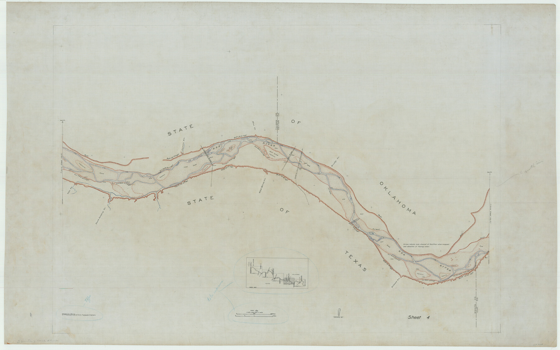
In the Supreme Court of the United States, The State of Oklahoma, Complainant vs. The State of Texas, Defendant, The United States of America, Intervener, Red River Valley, Texas and Oklahoma Between the 98th and 100th Meridians in Five Sheets, 1921
-
Map/Doc
75277
-
Collection
General Map Collection
-
Object Dates
1921 (Creation Date)
-
Subjects
Texas Boundaries
-
Height x Width
37.7 x 60.2 inches
95.8 x 152.9 cm
Part of: General Map Collection
Atascosa County Sketch File 28

Print $40.00
- Digital $50.00
Atascosa County Sketch File 28
1878
Size 27.9 x 21.7 inches
Map/Doc 10862
Mills County Sketch File 23

Print $4.00
- Digital $50.00
Mills County Sketch File 23
Size 12.4 x 9.2 inches
Map/Doc 31672
Current Miscellaneous File 33

Print $6.00
- Digital $50.00
Current Miscellaneous File 33
1953
Size 10.8 x 8.2 inches
Map/Doc 73939
Callahan County Working Sketch 10

Print $20.00
- Digital $50.00
Callahan County Working Sketch 10
1967
Size 26.9 x 25.5 inches
Map/Doc 67892

Hunt County Working Sketch 5

Print $20.00
- Digital $50.00
Hunt County Working Sketch 5
1942
Size 23.8 x 20.2 inches
Map/Doc 66352
Tyler County Sketch File 24

Print $16.00
- Digital $50.00
Tyler County Sketch File 24
1944
Size 11.2 x 9.0 inches
Map/Doc 38681
Brazos River, Brazos River Sheet 7

Print $6.00
- Digital $50.00
Brazos River, Brazos River Sheet 7
1926
Size 24.1 x 30.6 inches
Map/Doc 65300
Jackson County Working Sketch 7

Print $20.00
- Digital $50.00
Jackson County Working Sketch 7
1973
Size 35.7 x 27.1 inches
Map/Doc 66455
Cass County Sketch File 11

Print $6.00
- Digital $50.00
Cass County Sketch File 11
Size 10.4 x 14.4 inches
Map/Doc 17412
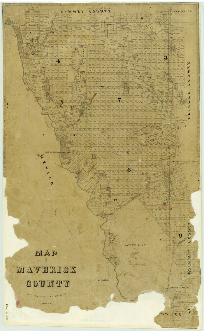
Map of Maverick County
Print $20.00
- Digital $50.00
Map of Maverick County
1878
Size 33.4 x 20.6 inches
Map/Doc 3850
Sketch No. 2 Showing Land Ties with Houston & Texas Central Rail Road through Harris County, Texas

Print $20.00
- Digital $50.00
Sketch No. 2 Showing Land Ties with Houston & Texas Central Rail Road through Harris County, Texas
1880
Size 8.5 x 26.9 inches
Map/Doc 64496
You may also like
Terrell County Working Sketch 56

Print $20.00
- Digital $50.00
Terrell County Working Sketch 56
Size 44.0 x 36.4 inches
Map/Doc 69577
Real County Rolled Sketch 18

Print $20.00
- Digital $50.00
Real County Rolled Sketch 18
Size 18.5 x 24.3 inches
Map/Doc 7462
Comanche County Working Sketch 28

Print $20.00
- Digital $50.00
Comanche County Working Sketch 28
1984
Size 22.9 x 25.7 inches
Map/Doc 68162
Chambers County Rolled Sketch 7

Print $20.00
- Digital $50.00
Chambers County Rolled Sketch 7
Size 39.8 x 23.1 inches
Map/Doc 8611
Map of Potter County

Print $20.00
- Digital $50.00
Map of Potter County
1895
Size 23.6 x 18.6 inches
Map/Doc 4589
Jim Wells County Working Sketch 4

Print $20.00
- Digital $50.00
Jim Wells County Working Sketch 4
1938
Size 44.1 x 32.8 inches
Map/Doc 66602
Texas (verso)

Print $20.00
- Digital $50.00
Texas (verso)
1833
Size 19.1 x 22.8 inches
Map/Doc 93837
[Sketch of Surveys south of League 153]
![90438, [Sketch of Surveys south of League 153], Twichell Survey Records](https://historictexasmaps.com/wmedia_w700/maps/90438-1.tif.jpg)
Print $2.00
- Digital $50.00
[Sketch of Surveys south of League 153]
Size 9.1 x 5.9 inches
Map/Doc 90438
Travis County Sketch File 77

Print $26.00
- Digital $50.00
Travis County Sketch File 77
2004
Size 11.0 x 8.5 inches
Map/Doc 83254
Real County Working Sketch 58

Print $4.00
- Digital $50.00
Real County Working Sketch 58
1962
Size 24.7 x 28.5 inches
Map/Doc 71950
[Sketch for Mineral Application 20124, North Fork of Red River]
![77087, [Sketch for Mineral Application 20124, North Fork of Red River], General Map Collection](https://www.historictexasmaps.com/skins/default/img/placeholder/w700.png)
Print $40.00
- Digital $50.00
[Sketch for Mineral Application 20124, North Fork of Red River]
Size 50.8 x 43.5 inches
Map/Doc 77087
Colorado County Rolled Sketch 3

Print $20.00
- Digital $50.00
Colorado County Rolled Sketch 3
1943
Size 42.4 x 38.7 inches
Map/Doc 8641