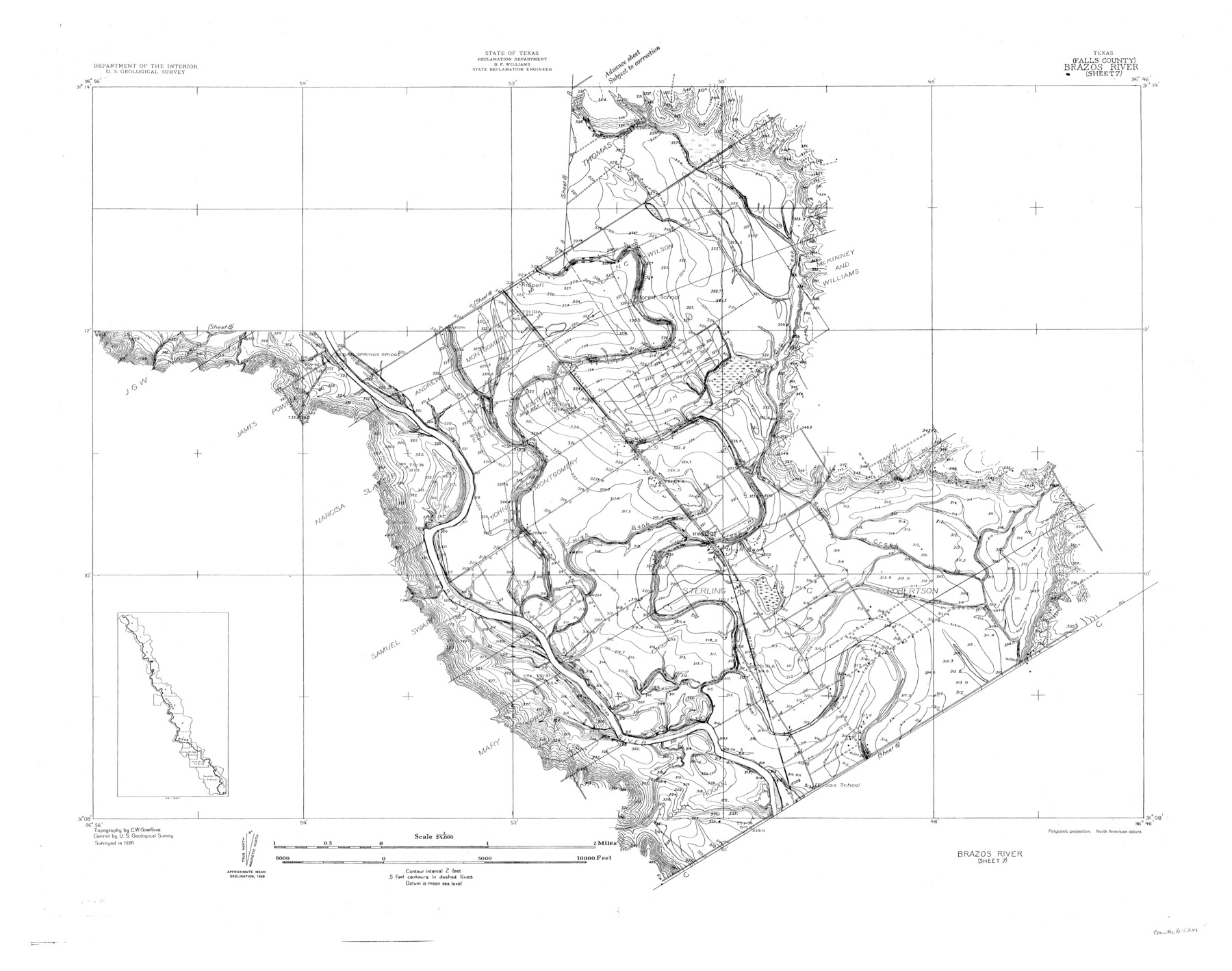
Brazos River, Brazos River Sheet 7
-
Map/Doc
65300
-
Collection
General Map Collection
-
Object Dates
1926 (Creation Date)
-
People and Organizations
Texas State Reclamation Department (Publisher)
C.W. Goodlove (Surveyor/Engineer)
-
Counties
Falls
-
Subjects
River Surveys Topographic
-
Height x Width
24.1 x 30.6 inches
61.2 x 77.7 cm
-
Comments
Brazos River Sheet 7 located north of the Brazos River Sheet 6 and south of the Brazos River Sheet 8.
Part of: General Map Collection
Map of Swisher County

Print $40.00
- Digital $50.00
Map of Swisher County
1900
Size 48.5 x 41.1 inches
Map/Doc 16890
Lynn County Sketch File 4

Print $12.00
- Digital $50.00
Lynn County Sketch File 4
1902
Size 12.8 x 8.2 inches
Map/Doc 30458
Texas 1973 Official Highway Travel Map

Texas 1973 Official Highway Travel Map
Size 28.1 x 36.3 inches
Map/Doc 94406
Carta Orografica

Print $20.00
- Digital $50.00
Carta Orografica
Size 26.0 x 34.4 inches
Map/Doc 96802
Bandera County Working Sketch 55

Print $20.00
- Digital $50.00
Bandera County Working Sketch 55
1990
Size 34.4 x 42.1 inches
Map/Doc 67651
Travis County Appraisal District Plat Map 2_1804

Print $20.00
- Digital $50.00
Travis County Appraisal District Plat Map 2_1804
Size 21.6 x 26.5 inches
Map/Doc 94203
Presidio County Sketch File 89

Print $10.00
- Digital $50.00
Presidio County Sketch File 89
1953
Size 14.3 x 8.9 inches
Map/Doc 34756
Navigation Maps of Gulf Intracoastal Waterway, Port Arthur to Brownsville, Texas

Print $4.00
- Digital $50.00
Navigation Maps of Gulf Intracoastal Waterway, Port Arthur to Brownsville, Texas
1951
Size 16.6 x 21.4 inches
Map/Doc 65448
Map of Brown County

Print $20.00
- Digital $50.00
Map of Brown County
1858
Size 25.7 x 25.3 inches
Map/Doc 3336
Crockett County Sketch File 51a

Print $10.00
- Digital $50.00
Crockett County Sketch File 51a
1922
Size 14.3 x 8.8 inches
Map/Doc 19812
McMullen County Working Sketch 26

Print $20.00
- Digital $50.00
McMullen County Working Sketch 26
1953
Size 17.8 x 14.5 inches
Map/Doc 70727
Lamb County Working Sketch 2

Print $20.00
- Digital $50.00
Lamb County Working Sketch 2
1919
Size 13.6 x 15.3 inches
Map/Doc 70275
You may also like
Map of N. W. Portion Blk G. Gaines Co.

Print $20.00
- Digital $50.00
Map of N. W. Portion Blk G. Gaines Co.
1914
Size 37.4 x 26.7 inches
Map/Doc 90867
Colton's rail road and county map of the southern states containing the latest information.

Print $20.00
Colton's rail road and county map of the southern states containing the latest information.
1864
Size 24.4 x 31.1 inches
Map/Doc 93570
La Salle County Boundary File 57b

Print $20.00
- Digital $50.00
La Salle County Boundary File 57b
Size 25.6 x 20.6 inches
Map/Doc 56258
Harris County Rolled Sketch 26

Print $20.00
- Digital $50.00
Harris County Rolled Sketch 26
Size 28.2 x 41.3 inches
Map/Doc 6094
Refugio County, Texas

Print $20.00
- Digital $50.00
Refugio County, Texas
1879
Size 19.9 x 29.0 inches
Map/Doc 600
Zapata County Sketch File 4

Print $22.00
- Digital $50.00
Zapata County Sketch File 4
1892
Size 14.5 x 17.5 inches
Map/Doc 40906
Cochran County

Print $20.00
- Digital $50.00
Cochran County
1946
Size 33.3 x 25.5 inches
Map/Doc 95456
Flight Mission No. DAG-18K, Frame 185, Matagorda County

Print $20.00
- Digital $50.00
Flight Mission No. DAG-18K, Frame 185, Matagorda County
1952
Size 16.2 x 15.9 inches
Map/Doc 86377
Kimble County Working Sketch 72

Print $20.00
- Digital $50.00
Kimble County Working Sketch 72
1966
Size 28.7 x 17.6 inches
Map/Doc 70140
Hood County Sketch File 9

Print $26.00
- Digital $50.00
Hood County Sketch File 9
1859
Size 9.6 x 4.5 inches
Map/Doc 26586
North Part of Brewster Co.

Print $20.00
- Digital $50.00
North Part of Brewster Co.
1956
Size 40.0 x 37.9 inches
Map/Doc 77220
Township No. 4 South Range No. 14 West of the Indian Meridian

Print $4.00
- Digital $50.00
Township No. 4 South Range No. 14 West of the Indian Meridian
1875
Size 18.0 x 22.4 inches
Map/Doc 75144