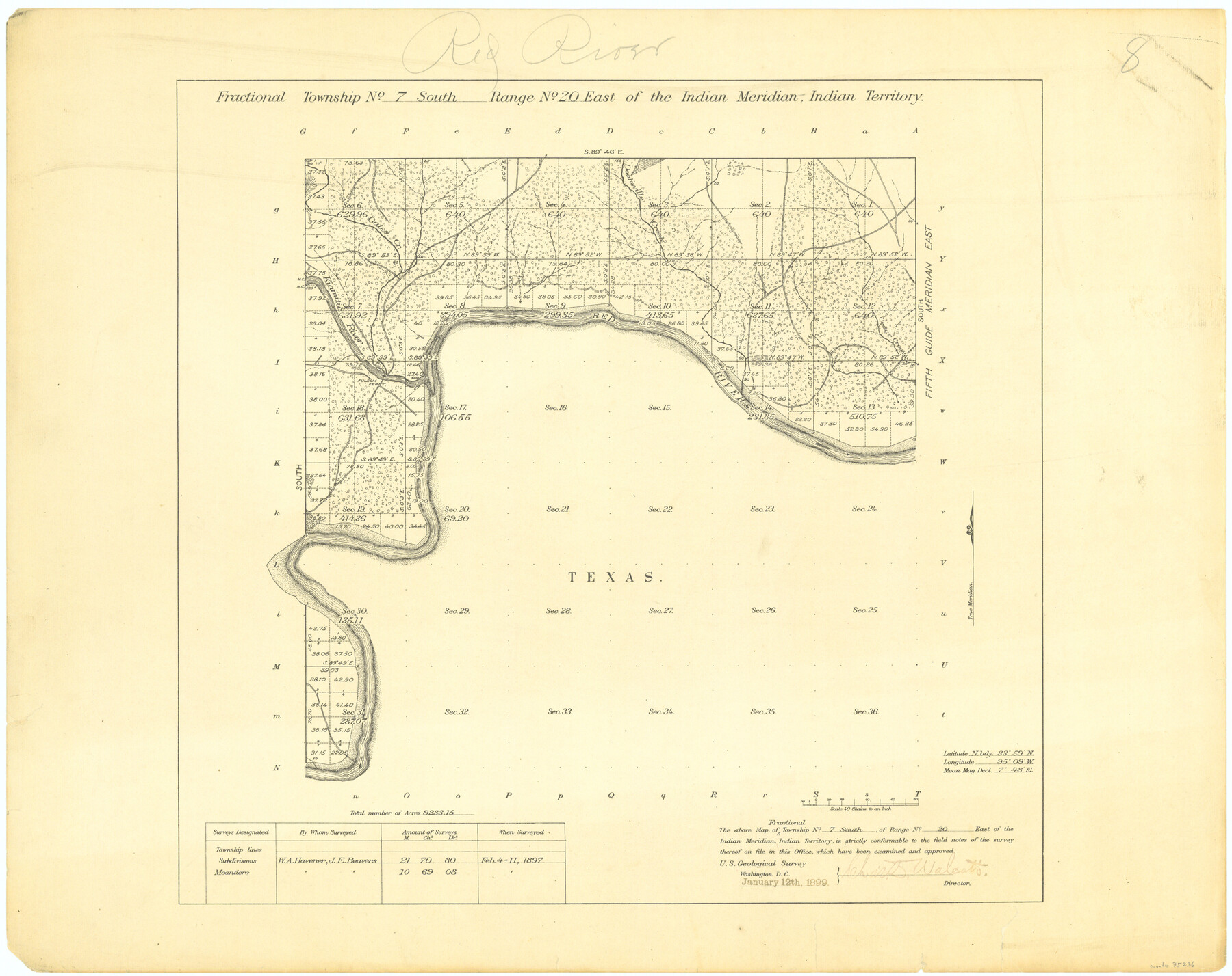
Fractional Township No. 7 South Range No. 20 East of the Indian Meridian, Indian Territory
-
Map/Doc
75236
-
Collection
General Map Collection
-
Object Dates
1897/2/11 (Creation Date)
-
Subjects
Texas Boundaries
-
Height x Width
19.2 x 24.2 inches
48.8 x 61.5 cm
Part of: General Map Collection
Hall County Sketch File C

Print $20.00
- Digital $50.00
Hall County Sketch File C
1905
Size 13.7 x 32.8 inches
Map/Doc 11614
Loving County Sketch File 3

Print $6.00
- Digital $50.00
Loving County Sketch File 3
1952
Size 11.2 x 8.7 inches
Map/Doc 30409
Kimble County

Print $40.00
- Digital $50.00
Kimble County
1930
Size 41.0 x 49.0 inches
Map/Doc 77340
Flight Mission No. DQN-2K, Frame 29, Calhoun County

Print $20.00
- Digital $50.00
Flight Mission No. DQN-2K, Frame 29, Calhoun County
1953
Size 18.7 x 22.3 inches
Map/Doc 84236
Map of Freestone County

Print $20.00
- Digital $50.00
Map of Freestone County
1858
Size 22.3 x 24.1 inches
Map/Doc 3564
El Paso County Rolled Sketch Z60
Print $20.00
- Digital $50.00
El Paso County Rolled Sketch Z60
1915
Size 37.3 x 47.7 inches
Map/Doc 8873
Flight Mission No. BRA-16M, Frame 119, Jefferson County

Print $20.00
- Digital $50.00
Flight Mission No. BRA-16M, Frame 119, Jefferson County
1953
Size 18.6 x 22.5 inches
Map/Doc 85729
Flight Mission No. CUG-1P, Frame 165, Kleberg County

Print $20.00
- Digital $50.00
Flight Mission No. CUG-1P, Frame 165, Kleberg County
1956
Size 18.7 x 22.2 inches
Map/Doc 86172
Lampasas River, City of Lampasas, Lampasas Sheet/Sulphur & Burleson Creeks

Print $20.00
- Digital $50.00
Lampasas River, City of Lampasas, Lampasas Sheet/Sulphur & Burleson Creeks
1937
Size 33.4 x 19.3 inches
Map/Doc 16956
Chambers County Working Sketch 5

Print $20.00
- Digital $50.00
Chambers County Working Sketch 5
1938
Size 20.9 x 31.6 inches
Map/Doc 67988
Kendall County Rolled Sketch 4

Print $20.00
- Digital $50.00
Kendall County Rolled Sketch 4
1945
Size 29.9 x 27.0 inches
Map/Doc 6457
Colorado County Sketch File 28

Print $17.00
- Digital $50.00
Colorado County Sketch File 28
1935
Size 9.1 x 7.7 inches
Map/Doc 18966
You may also like
Flight Mission No. CRC-4R, Frame 184, Chambers County

Print $20.00
- Digital $50.00
Flight Mission No. CRC-4R, Frame 184, Chambers County
1956
Size 18.6 x 22.3 inches
Map/Doc 84935
Capitol Complex, Austin, Texas

Print $20.00
- Digital $50.00
Capitol Complex, Austin, Texas
1974
Size 42.7 x 30.6 inches
Map/Doc 94241
Bosque County Working Sketch 14

Print $20.00
- Digital $50.00
Bosque County Working Sketch 14
1962
Size 24.1 x 23.3 inches
Map/Doc 67447
Bowie County Rolled Sketch 1

Print $20.00
- Digital $50.00
Bowie County Rolled Sketch 1
1965
Size 32.0 x 46.1 inches
Map/Doc 8927
Houston Ship Channel, Alexander Island to Carpenter Bayou

Print $40.00
- Digital $50.00
Houston Ship Channel, Alexander Island to Carpenter Bayou
1992
Size 35.3 x 49.3 inches
Map/Doc 69917
La Salle County Working Sketch 2

Print $20.00
- Digital $50.00
La Salle County Working Sketch 2
1886
Size 17.6 x 16.0 inches
Map/Doc 70303
[Sketch of common corner of Oldham, Potter, Deaf Smith and Randall Counties]
![93060, [Sketch of common corner of Oldham, Potter, Deaf Smith and Randall Counties], Twichell Survey Records](https://historictexasmaps.com/wmedia_w700/maps/93060-1.tif.jpg)
Print $20.00
- Digital $50.00
[Sketch of common corner of Oldham, Potter, Deaf Smith and Randall Counties]
Size 17.2 x 33.1 inches
Map/Doc 93060
Map showing survey for proposed ship channel from Brownsville to Brazos Santiago Pass

Print $20.00
- Digital $50.00
Map showing survey for proposed ship channel from Brownsville to Brazos Santiago Pass
1912
Size 18.4 x 28.4 inches
Map/Doc 72900
Flight Mission No. DQN-2K, Frame 122, Calhoun County

Print $4.00
- Digital $50.00
Flight Mission No. DQN-2K, Frame 122, Calhoun County
1953
Size 18.5 x 22.2 inches
Map/Doc 84298
St. Louis Southwestern Railway of Texas

Print $20.00
- Digital $50.00
St. Louis Southwestern Railway of Texas
1906
Size 22.6 x 30.3 inches
Map/Doc 64448
Stephens County Working Sketch 4

Print $20.00
- Digital $50.00
Stephens County Working Sketch 4
1919
Size 32.1 x 26.5 inches
Map/Doc 63947
Map of Denton County

Print $20.00
- Digital $50.00
Map of Denton County
1897
Size 42.7 x 39.5 inches
Map/Doc 4932