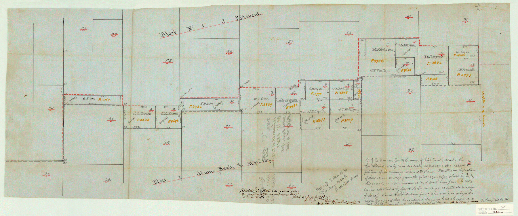
Hall County Sketch File C
J. E. Hamm's sk. of surs. around Blk. "A", A. B. & M.
-
Map/Doc
11614
-
Collection
General Map Collection
-
Object Dates
9/5/1905 (Creation Date)
10/4/1905 (File Date)
-
People and Organizations
James E. Hamm (Surveyor/Engineer)
M.E. Ragsdale (Surveyor/Engineer)
Joseph H. Parks (Surveyor/Engineer)
-
Counties
Hall
-
Subjects
Surveying Sketch File
-
Height x Width
13.7 x 32.8 inches
34.8 x 83.3 cm
-
Medium
paper, manuscript
-
Comments
Scale in title block: 1/50 inch = 40 varas
Part of: General Map Collection
Rockwall County Boundary File 52a

Print $22.00
- Digital $50.00
Rockwall County Boundary File 52a
Size 12.9 x 8.3 inches
Map/Doc 58461
Flight Mission No. DCL-7C, Frame 12, Kenedy County

Print $20.00
- Digital $50.00
Flight Mission No. DCL-7C, Frame 12, Kenedy County
1943
Size 15.4 x 15.3 inches
Map/Doc 86004
Gray County Boundary File 8

Print $4.00
- Digital $50.00
Gray County Boundary File 8
Size 14.5 x 9.1 inches
Map/Doc 53900
[St. L. S-W. Ry. of Texas Map of Lufkin Branch in Angelina County, Texas]
![64561, [St. L. S-W. Ry. of Texas Map of Lufkin Branch in Angelina County, Texas], General Map Collection](https://historictexasmaps.com/wmedia_w700/maps/64561-1.tif.jpg)
Print $40.00
- Digital $50.00
[St. L. S-W. Ry. of Texas Map of Lufkin Branch in Angelina County, Texas]
1913
Size 25.4 x 121.3 inches
Map/Doc 64561
Map of the Country upon Upper Red-River explored in 1852 by Capt. R.B. Marcy 5th U.S. Infy. assisted by Bvt. Capt. G.B. McClellan U.S. Engs. under orders from the Head Quarters of the U.S. Army

Print $20.00
- Digital $50.00
Map of the Country upon Upper Red-River explored in 1852 by Capt. R.B. Marcy 5th U.S. Infy. assisted by Bvt. Capt. G.B. McClellan U.S. Engs. under orders from the Head Quarters of the U.S. Army
Size 18.7 x 36.0 inches
Map/Doc 95320
J. De Cordova's Map of the State of Texas Compiled from the records of the General Land Office of the State

Print $20.00
- Digital $50.00
J. De Cordova's Map of the State of Texas Compiled from the records of the General Land Office of the State
1849
Size 34.0 x 31.5 inches
Map/Doc 656

Nueces County Rolled Sketch 32

Print $20.00
- Digital $50.00
Nueces County Rolled Sketch 32
Size 17.0 x 17.2 inches
Map/Doc 6876
Outer Continental Shelf Leasing Maps (Texas Offshore Operations)

Print $20.00
- Digital $50.00
Outer Continental Shelf Leasing Maps (Texas Offshore Operations)
Size 24.0 x 18.4 inches
Map/Doc 75853
Harrison County Sketch File 16

Print $20.00
- Digital $50.00
Harrison County Sketch File 16
1910
Size 41.7 x 27.5 inches
Map/Doc 10488
Gillespie County Working Sketch 5

Print $20.00
- Digital $50.00
Gillespie County Working Sketch 5
1972
Size 25.7 x 25.9 inches
Map/Doc 63168
Chambers County Aerial Photograph Index Sheet 6

Print $20.00
- Digital $50.00
Chambers County Aerial Photograph Index Sheet 6
1956
Size 19.4 x 15.2 inches
Map/Doc 83687
You may also like

Panola County Sketch File 30

Print $4.00
- Digital $50.00
Panola County Sketch File 30
1944
Size 2.8 x 8.9 inches
Map/Doc 33505
Map of Padre Island Showing Location of Zoning Districts

Print $20.00
- Digital $50.00
Map of Padre Island Showing Location of Zoning Districts
1971
Size 18.8 x 26.7 inches
Map/Doc 4809
Cherokee County Sketch File 12

Print $4.00
- Digital $50.00
Cherokee County Sketch File 12
1860
Size 6.7 x 8.3 inches
Map/Doc 18140
McMullen County Working Sketch 8

Print $20.00
- Digital $50.00
McMullen County Working Sketch 8
1936
Size 27.2 x 33.0 inches
Map/Doc 70709
Leon County Working Sketch 61

Print $20.00
- Digital $50.00
Leon County Working Sketch 61
2010
Size 35.8 x 38.7 inches
Map/Doc 89986
Rockwall County Boundary File 5

Print $44.00
- Digital $50.00
Rockwall County Boundary File 5
Size 4.1 x 9.2 inches
Map/Doc 58407
Flight Mission No. DAG-24K, Frame 139, Matagorda County

Print $20.00
- Digital $50.00
Flight Mission No. DAG-24K, Frame 139, Matagorda County
1953
Size 18.5 x 22.3 inches
Map/Doc 86557
Lubbock County Boundary File 11

Print $68.00
- Digital $50.00
Lubbock County Boundary File 11
Size 14.7 x 9.2 inches
Map/Doc 56583
Starr County Working Sketch 24

Print $20.00
- Digital $50.00
Starr County Working Sketch 24
1988
Size 37.1 x 20.2 inches
Map/Doc 63940
Austin County Boundary File 5a

Print $6.00
- Digital $50.00
Austin County Boundary File 5a
Size 14.1 x 8.7 inches
Map/Doc 50252
Pecos County Rolled Sketch JAS-1

Print $40.00
- Digital $50.00
Pecos County Rolled Sketch JAS-1
1936
Size 41.8 x 63.8 inches
Map/Doc 76146