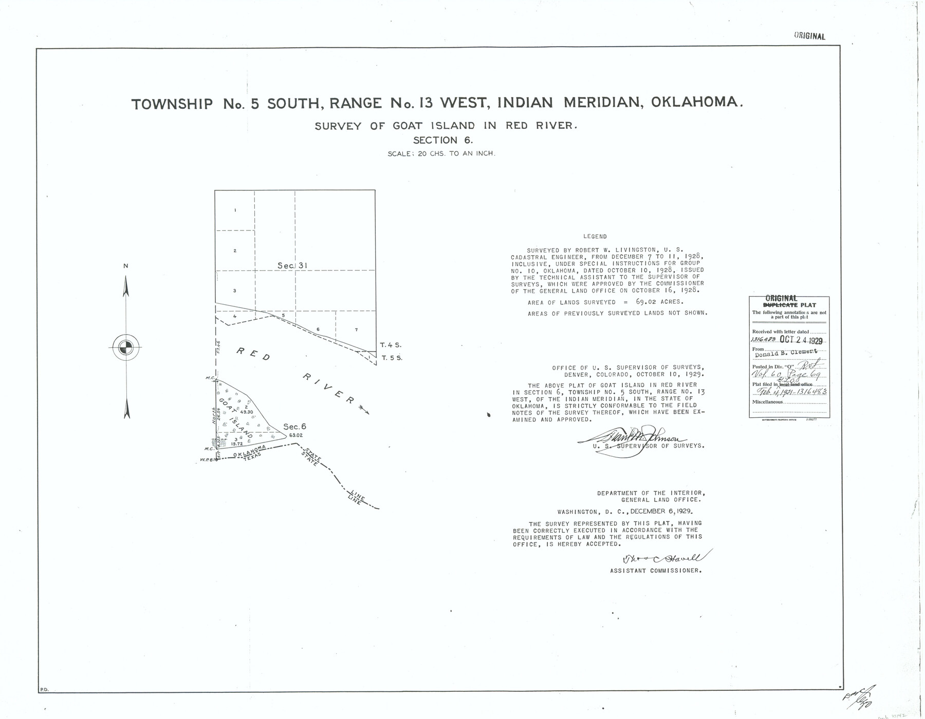
Township No. 5 South, Range No. 13 West, Indian Meridian, Oklahoma
Survey of Goat Island in Red River, Section 6
-
Map/Doc
75142
-
Collection
General Map Collection
-
Object Dates
1928/12/11 (Creation Date)
-
Subjects
Texas Boundaries
-
Height x Width
17.9 x 23.0 inches
45.5 x 58.4 cm
Part of: General Map Collection
Tom Green County Sketch File 30

Print $12.00
Tom Green County Sketch File 30
1880
Size 11.0 x 8.2 inches
Map/Doc 38182
Reeves County Sketch File 6

Print $20.00
- Digital $50.00
Reeves County Sketch File 6
Size 17.3 x 28.3 inches
Map/Doc 12242
Live Oak County Sketch File 32

Print $6.00
- Digital $50.00
Live Oak County Sketch File 32
1951
Size 11.1 x 8.6 inches
Map/Doc 30330
Controlled Mosaic by Jack Amman Photogrammetric Engineers, Inc - Sheet 28

Print $20.00
- Digital $50.00
Controlled Mosaic by Jack Amman Photogrammetric Engineers, Inc - Sheet 28
1954
Size 20.0 x 24.0 inches
Map/Doc 83479
Edwards County Sketch File 11

Print $26.00
- Digital $50.00
Edwards County Sketch File 11
1887
Size 13.7 x 8.8 inches
Map/Doc 21687
Upton County Rolled Sketch 20

Print $40.00
- Digital $50.00
Upton County Rolled Sketch 20
1933
Size 53.0 x 36.8 inches
Map/Doc 10041
Flight Mission No. DCL-7C, Frame 150, Kenedy County

Print $20.00
- Digital $50.00
Flight Mission No. DCL-7C, Frame 150, Kenedy County
1943
Size 18.5 x 22.2 inches
Map/Doc 86107
Goliad County Sketch File 21

Print $10.00
- Digital $50.00
Goliad County Sketch File 21
1855
Size 12.0 x 7.9 inches
Map/Doc 24284
Wharton County Sketch File A1

Print $20.00
- Digital $50.00
Wharton County Sketch File A1
1895
Size 15.6 x 36.4 inches
Map/Doc 12669
Proceedings of the International Boundary Commission, United States and Mexico, American Section, Elimination of Bancos, Treaty of 1905

Proceedings of the International Boundary Commission, United States and Mexico, American Section, Elimination of Bancos, Treaty of 1905
Size 12.4 x 9.6 inches
Map/Doc 83125
Montgomery County Rolled Sketch 39

Print $20.00
- Digital $50.00
Montgomery County Rolled Sketch 39
1967
Size 23.8 x 27.9 inches
Map/Doc 6813
Rusk County Sketch File 13

Print $4.00
Rusk County Sketch File 13
Size 8.6 x 6.4 inches
Map/Doc 35514
You may also like
Map of the Houston Ship Channel showing all industries, railways, public and private docks, and approximate all original surveys in the vicinity of the channel

Print $20.00
- Digital $50.00
Map of the Houston Ship Channel showing all industries, railways, public and private docks, and approximate all original surveys in the vicinity of the channel
1925
Size 14.5 x 30.2 inches
Map/Doc 4666
Sabine River, Iron Bridge Crossing Sheet

Print $20.00
- Digital $50.00
Sabine River, Iron Bridge Crossing Sheet
1936
Size 33.0 x 40.6 inches
Map/Doc 65139
Taylor County

Print $20.00
- Digital $50.00
Taylor County
1934
Size 44.8 x 39.0 inches
Map/Doc 95650
Map of the British Isles designed to accompany Smith's Geography for Schools

Print $20.00
- Digital $50.00
Map of the British Isles designed to accompany Smith's Geography for Schools
1850
Size 12.1 x 9.8 inches
Map/Doc 93894
Motley County Sketch File 7 (N)

Print $20.00
- Digital $50.00
Motley County Sketch File 7 (N)
1901
Size 16.0 x 19.8 inches
Map/Doc 42140
Liberty County Sketch File 43

Print $4.00
- Digital $50.00
Liberty County Sketch File 43
1863
Size 13.6 x 8.5 inches
Map/Doc 30000
Pecos County Rolled Sketch 180

Print $20.00
- Digital $50.00
Pecos County Rolled Sketch 180
Size 33.6 x 42.0 inches
Map/Doc 9752
Medina County Sketch File 19

Print $20.00
- Digital $50.00
Medina County Sketch File 19
1989
Size 32.5 x 21.0 inches
Map/Doc 12071
Falls County Sketch File 11a

Print $8.00
- Digital $50.00
Falls County Sketch File 11a
1871
Size 12.9 x 8.2 inches
Map/Doc 22358
Foard County Sketch File 34

Print $20.00
- Digital $50.00
Foard County Sketch File 34
1889
Size 29.1 x 24.9 inches
Map/Doc 11497
Pecos County Rolled Sketch 104

Print $40.00
- Digital $50.00
Pecos County Rolled Sketch 104
Size 42.5 x 54.8 inches
Map/Doc 78197
Starr County Sketch File 48a

Print $40.00
- Digital $50.00
Starr County Sketch File 48a
1950
Size 9.0 x 22.0 inches
Map/Doc 37005