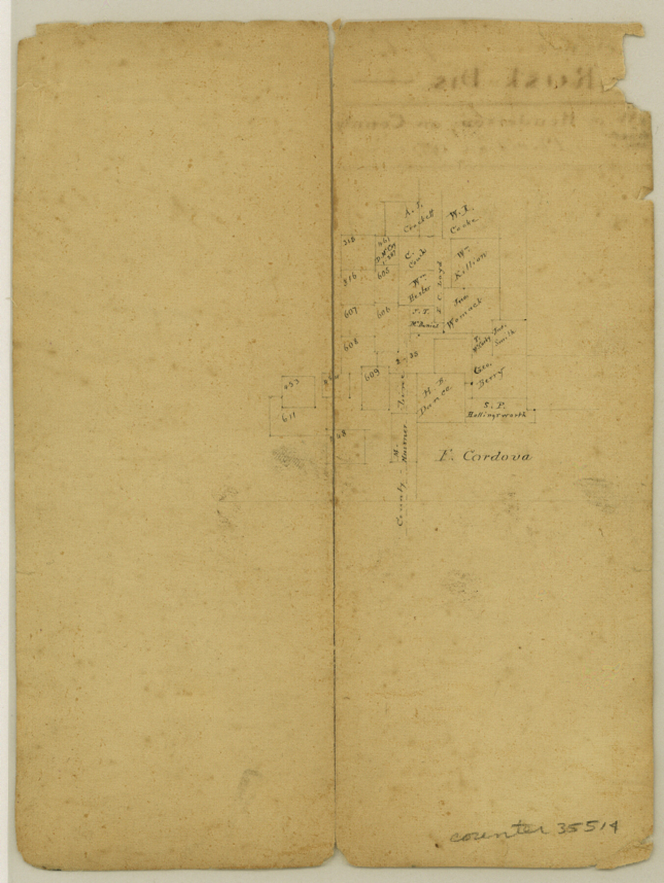
Rusk County Sketch File 13
[Sketch showing area spanning the Rusk-Smith County line northwest of Henderson]
-
Map/Doc
35514
-
Collection
General Map Collection
-
Counties
Rusk Smith
-
Subjects
Surveying Sketch File
-
Height x Width
8.6 x 6.4 inches
21.8 x 16.3 cm
-
Medium
paper, manuscript
Part of: General Map Collection
Map of DeWitt County

Print $20.00
- Digital $50.00
Map of DeWitt County
1853
Size 21.5 x 25.5 inches
Map/Doc 3479
DeWitt County Sketch File 6

Print $24.00
- Digital $50.00
DeWitt County Sketch File 6
1872
Size 9.8 x 8.5 inches
Map/Doc 20805
Cass County Working Sketch 44

Print $20.00
- Digital $50.00
Cass County Working Sketch 44
1989
Size 21.3 x 30.3 inches
Map/Doc 67947
Anderson County Working Sketch 43

Print $20.00
- Digital $50.00
Anderson County Working Sketch 43
1988
Size 37.2 x 33.9 inches
Map/Doc 67043
Runnels County

Print $40.00
- Digital $50.00
Runnels County
1948
Size 49.4 x 38.7 inches
Map/Doc 63010
Flight Mission No. CRE-2R, Frame 167, Jackson County

Print $20.00
- Digital $50.00
Flight Mission No. CRE-2R, Frame 167, Jackson County
1956
Size 18.6 x 22.4 inches
Map/Doc 85377
[Maps of surveys in Reeves & Culberson Cos]
![61143, [Maps of surveys in Reeves & Culberson Cos], General Map Collection](https://historictexasmaps.com/wmedia_w700/maps/61143.tif.jpg)
Print $20.00
- Digital $50.00
[Maps of surveys in Reeves & Culberson Cos]
1937
Size 30.7 x 24.9 inches
Map/Doc 61143
Tom Green County Sketch File 50

Print $20.00
- Digital $50.00
Tom Green County Sketch File 50
1884
Size 25.4 x 34.5 inches
Map/Doc 12442
Map of Brassos [sic] & Bosque Surveys
![146, Map of Brassos [sic] & Bosque Surveys, General Map Collection](https://historictexasmaps.com/wmedia_w700/maps/146.tif.jpg)
Print $20.00
- Digital $50.00
Map of Brassos [sic] & Bosque Surveys
1841
Size 27.7 x 18.9 inches
Map/Doc 146
Fractional Township No. 8 South Range No. 11 East of the Indian Meridian, Indian Territory

Print $20.00
- Digital $50.00
Fractional Township No. 8 South Range No. 11 East of the Indian Meridian, Indian Territory
1896
Size 19.3 x 24.4 inches
Map/Doc 75222
Zavala County Rolled Sketch 31

Print $20.00
- Digital $50.00
Zavala County Rolled Sketch 31
1883
Size 37.4 x 27.1 inches
Map/Doc 8332
McLennan County

Print $20.00
- Digital $50.00
McLennan County
1872
Size 16.3 x 21.9 inches
Map/Doc 3863
You may also like
Calhoun County NRC Article 33.136 Sketch 9

Print $106.00
- Digital $50.00
Calhoun County NRC Article 33.136 Sketch 9
2021
Map/Doc 96913
Map of the Texas & Pacific Ry. Reserve West of the Pecos River

Print $20.00
- Digital $50.00
Map of the Texas & Pacific Ry. Reserve West of the Pecos River
1879
Size 41.2 x 29.9 inches
Map/Doc 65334
Map of the Fort Worth & Denver City Railway, Oldham County, Texas

Print $40.00
- Digital $50.00
Map of the Fort Worth & Denver City Railway, Oldham County, Texas
1887
Size 24.8 x 105.2 inches
Map/Doc 64456
Hutchinson County Sketch File 25

Print $6.00
- Digital $50.00
Hutchinson County Sketch File 25
1922
Size 11.2 x 8.8 inches
Map/Doc 27258
Bexar County Sketch File 33

Print $4.00
- Digital $50.00
Bexar County Sketch File 33
Size 10.7 x 8.5 inches
Map/Doc 14496
Flight Mission No. DCL-4C, Frame 69, Kenedy County

Print $20.00
- Digital $50.00
Flight Mission No. DCL-4C, Frame 69, Kenedy County
1943
Size 18.7 x 22.3 inches
Map/Doc 85814
Texas State Boundary Line 4

Print $20.00
- Digital $50.00
Texas State Boundary Line 4
Size 11.2 x 8.7 inches
Map/Doc 74949
Flight Mission No. DAG-21K, Frame 98, Matagorda County

Print $20.00
- Digital $50.00
Flight Mission No. DAG-21K, Frame 98, Matagorda County
1952
Size 18.5 x 22.3 inches
Map/Doc 86427
[Beaty and Moulton Block A, Southern Pacific Railroad Block 2]
![91398, [Beaty and Moulton Block A, Southern Pacific Railroad Block 2], Twichell Survey Records](https://historictexasmaps.com/wmedia_w700/maps/91398-1.tif.jpg)
Print $20.00
- Digital $50.00
[Beaty and Moulton Block A, Southern Pacific Railroad Block 2]
1914
Size 24.2 x 15.4 inches
Map/Doc 91398
La Salle County Working Sketch 9

Print $20.00
- Digital $50.00
La Salle County Working Sketch 9
1925
Size 21.2 x 15.6 inches
Map/Doc 70310
Matagorda County NRC Article 33.136 Sketch 19

Print $24.00
Matagorda County NRC Article 33.136 Sketch 19
2023
Map/Doc 97268
Texas Intracoastal Waterway - Port O'Connor to San Antonio Bay, Including Pass Cavallo

Print $20.00
- Digital $50.00
Texas Intracoastal Waterway - Port O'Connor to San Antonio Bay, Including Pass Cavallo
1961
Size 26.5 x 38.7 inches
Map/Doc 73373