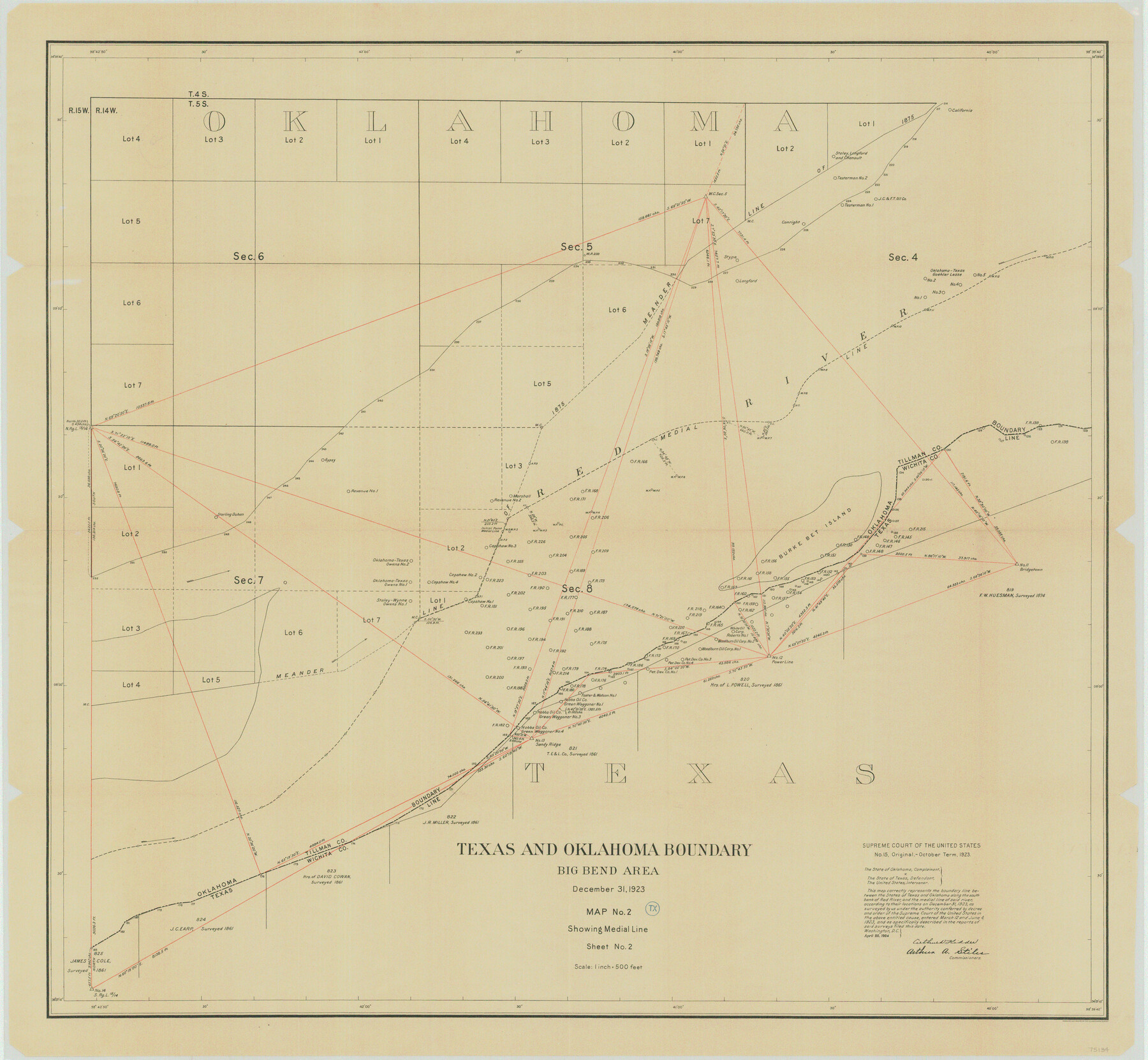
Supreme Court of the United States, October Term, 1923, No. 15, Original - The State of Oklahoma, Complainant vs. The State of Texas, Defendant, The United States, Intervener; Report of the Boundary Commissioners
Report of the Boundary Commissioners
-
Map/Doc
75134
-
Collection
General Map Collection
-
Object Dates
1923/12/31 (Creation Date)
-
Subjects
Texas Boundaries Topographic
-
Height x Width
33.9 x 36.8 inches
86.1 x 93.5 cm
Part of: General Map Collection
Jasper County Rolled Sketch 5

Print $20.00
- Digital $50.00
Jasper County Rolled Sketch 5
1948
Size 29.0 x 24.4 inches
Map/Doc 6352
Flight Mission No. BRE-1P, Frame 79, Nueces County

Print $20.00
- Digital $50.00
Flight Mission No. BRE-1P, Frame 79, Nueces County
1956
Size 18.4 x 22.2 inches
Map/Doc 86661
Randall County Working Sketch 2

Print $20.00
- Digital $50.00
Randall County Working Sketch 2
1980
Size 28.6 x 31.3 inches
Map/Doc 71839
Crockett County Sketch File 91

Print $76.00
- Digital $50.00
Crockett County Sketch File 91
1968
Size 11.3 x 8.8 inches
Map/Doc 19918
Culberson County Rolled Sketch 50

Print $20.00
- Digital $50.00
Culberson County Rolled Sketch 50
1963
Size 19.3 x 25.0 inches
Map/Doc 5669
Flight Mission No. DQN-2K, Frame 69, Calhoun County

Print $20.00
- Digital $50.00
Flight Mission No. DQN-2K, Frame 69, Calhoun County
1953
Size 16.2 x 16.1 inches
Map/Doc 84261
Brazoria County Rolled Sketch 40

Print $20.00
- Digital $50.00
Brazoria County Rolled Sketch 40
1954
Size 32.1 x 21.5 inches
Map/Doc 5175
Presidio County Sketch File 1

Print $40.00
- Digital $50.00
Presidio County Sketch File 1
1857
Size 24.7 x 16.0 inches
Map/Doc 11703
Ochiltree County Sketch File 2

Print $38.00
- Digital $50.00
Ochiltree County Sketch File 2
1903
Size 11.3 x 8.6 inches
Map/Doc 33168
Ward County Working Sketch 4

Print $20.00
- Digital $50.00
Ward County Working Sketch 4
1943
Size 17.0 x 16.7 inches
Map/Doc 72310
Map of Maverick County

Print $20.00
- Digital $50.00
Map of Maverick County
1875
Size 36.3 x 23.7 inches
Map/Doc 3849

You may also like
Nueces County Sketch File A

Print $10.00
- Digital $50.00
Nueces County Sketch File A
1879
Size 14.9 x 10.3 inches
Map/Doc 32493
Chambers County NRC Article 33.136 Sketch 9

Print $24.00
- Digital $50.00
Chambers County NRC Article 33.136 Sketch 9
2014
Size 17.7 x 24.0 inches
Map/Doc 94747
General Highway Map, Gray County, Texas

Print $20.00
General Highway Map, Gray County, Texas
1961
Size 18.1 x 24.7 inches
Map/Doc 79483
Collingsworth County Sketch File 7

Print $10.00
- Digital $50.00
Collingsworth County Sketch File 7
1915
Size 11.4 x 9.0 inches
Map/Doc 18884
[Sketch for Mineral Application 13436 - Cut-off Bayou]
![65675, [Sketch for Mineral Application 13436 - Cut-off Bayou], General Map Collection](https://historictexasmaps.com/wmedia_w700/maps/65675-1.tif.jpg)
Print $20.00
- Digital $50.00
[Sketch for Mineral Application 13436 - Cut-off Bayou]
1928
Size 21.3 x 44.3 inches
Map/Doc 65675
[Block T, Sabine County School Land, and vicinity]
![92250, [Block T, Sabine County School Land, and vicinity], Twichell Survey Records](https://historictexasmaps.com/wmedia_w700/maps/92250-1.tif.jpg)
Print $20.00
- Digital $50.00
[Block T, Sabine County School Land, and vicinity]
Size 35.7 x 32.0 inches
Map/Doc 92250
Ellis County Boundary File 3a

Print $10.00
- Digital $50.00
Ellis County Boundary File 3a
Size 11.2 x 8.9 inches
Map/Doc 52960
Wood County Working Sketch 23

Print $40.00
- Digital $50.00
Wood County Working Sketch 23
1962
Size 54.9 x 43.5 inches
Map/Doc 78230
[Surveying Sketch of John Poitevent Block 1, Railroad Lands, et al in Knox County, Texas]
![414, [Surveying Sketch of John Poitevent Block 1, Railroad Lands, et al in Knox County, Texas], Maddox Collection](https://historictexasmaps.com/wmedia_w700/maps/0414.tif.jpg)
Print $3.00
- Digital $50.00
[Surveying Sketch of John Poitevent Block 1, Railroad Lands, et al in Knox County, Texas]
Size 11.9 x 14.2 inches
Map/Doc 414
Terrell County Working Sketch 30

Print $20.00
- Digital $50.00
Terrell County Working Sketch 30
1944
Size 31.4 x 25.2 inches
Map/Doc 62122
McMullen County Rolled Sketch 11

Print $20.00
- Digital $50.00
McMullen County Rolled Sketch 11
Size 32.2 x 22.3 inches
Map/Doc 6728
