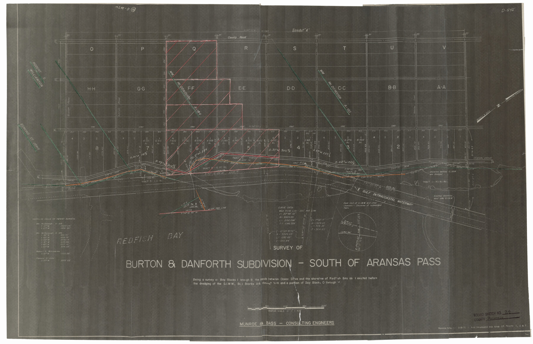
Aransas County Rolled Sketch 24
Survey of Burton & Danforth Subdivision - South of Aransas Pass being a survey of Bay Blocks 1 through 8, the lands between Ocean Drive and the shoreline of Redfish Bay as it existed before the dredging of the G.I.W.W.
-
Map/Doc
77495
-
Collection
General Map Collection
-
Object Dates
1970/5/18 (Revision Date)
1983/1/12 (File Date)
-
People and Organizations
Munroe & Bass (Surveyor/Engineer)
-
Counties
Aransas
-
Subjects
Surveying Rolled Sketch
-
Height x Width
22.5 x 34.8 inches
57.2 x 88.4 cm
-
Medium
van dyke/brownline/sepia
-
Scale
1" = 400'
Part of: General Map Collection
Uvalde County Working Sketch 43

Print $20.00
- Digital $50.00
Uvalde County Working Sketch 43
1978
Size 29.3 x 27.7 inches
Map/Doc 72113
Upton County Sketch File 14CF

Print $8.00
- Digital $50.00
Upton County Sketch File 14CF
1926
Size 11.3 x 8.8 inches
Map/Doc 38860
Motley County Sketch File 6B (S)

Print $20.00
- Digital $50.00
Motley County Sketch File 6B (S)
Size 24.5 x 20.7 inches
Map/Doc 42139
Current Miscellaneous File 47

Print $12.00
- Digital $50.00
Current Miscellaneous File 47
1920
Size 16.3 x 9.2 inches
Map/Doc 73992
Dimmit County Working Sketch 21

Print $20.00
- Digital $50.00
Dimmit County Working Sketch 21
1950
Size 35.1 x 18.8 inches
Map/Doc 68682
Erath County Rolled Sketch 3A

Print $20.00
- Digital $50.00
Erath County Rolled Sketch 3A
1982
Size 21.7 x 27.8 inches
Map/Doc 5865
Harris County Working Sketch 10

Print $20.00
- Digital $50.00
Harris County Working Sketch 10
1912
Size 25.7 x 18.1 inches
Map/Doc 65902
Johnson County Working Sketch 24

Print $20.00
- Digital $50.00
Johnson County Working Sketch 24
1996
Size 47.5 x 34.5 inches
Map/Doc 66637
Map of Extension Line from the Brazos River to the Waters of the Colorado River of the Memphis, El Paso & Pacific R.R. Company Land Reserve

Print $40.00
- Digital $50.00
Map of Extension Line from the Brazos River to the Waters of the Colorado River of the Memphis, El Paso & Pacific R.R. Company Land Reserve
1858
Size 16.8 x 82.9 inches
Map/Doc 64093
Blanco County Working Sketch 14

Print $20.00
- Digital $50.00
Blanco County Working Sketch 14
1948
Size 36.2 x 28.8 inches
Map/Doc 67374
[Sketch for Mineral Application 16787 - Pecos River Bed, A. T. Freet]
![65632, [Sketch for Mineral Application 16787 - Pecos River Bed, A. T. Freet], General Map Collection](https://historictexasmaps.com/wmedia_w700/maps/65632-1.tif.jpg)
Print $40.00
- Digital $50.00
[Sketch for Mineral Application 16787 - Pecos River Bed, A. T. Freet]
Size 70.8 x 18.9 inches
Map/Doc 65632
G No. 2 - Reconnaissance of Channel No. IV Cedar-Keys, Florida

Print $20.00
- Digital $50.00
G No. 2 - Reconnaissance of Channel No. IV Cedar-Keys, Florida
1852
Size 10.8 x 12.6 inches
Map/Doc 97220
You may also like
Sketch of the line of march of the 2nd US Dragoons commanded by Col D. E. Tuiggs from Fort Jesup, La to Corpus Christi, Texas between the 25th of July and the 27th Aug, 1845

Print $20.00
- Digital $50.00
Sketch of the line of march of the 2nd US Dragoons commanded by Col D. E. Tuiggs from Fort Jesup, La to Corpus Christi, Texas between the 25th of July and the 27th Aug, 1845
1845
Size 25.4 x 18.3 inches
Map/Doc 72724
Flight Mission No. DQN-5K, Frame 23, Calhoun County

Print $20.00
- Digital $50.00
Flight Mission No. DQN-5K, Frame 23, Calhoun County
1953
Size 18.5 x 22.1 inches
Map/Doc 84374
Val Verde County Working Sketch 17

Print $20.00
- Digital $50.00
Val Verde County Working Sketch 17
1926
Size 16.5 x 27.8 inches
Map/Doc 72152
Zapata County Working Sketch 11

Print $20.00
- Digital $50.00
Zapata County Working Sketch 11
1958
Size 38.1 x 28.7 inches
Map/Doc 62062
County Map of the State of Texas Showing also portions of the Adjoining States and Territories (Inset: Plan of Galveston and Vicinity)

Print $20.00
- Digital $50.00
County Map of the State of Texas Showing also portions of the Adjoining States and Territories (Inset: Plan of Galveston and Vicinity)
1873
Size 15.5 x 23.1 inches
Map/Doc 93696
Flight Mission No. BRA-7M, Frame 24, Jefferson County

Print $20.00
- Digital $50.00
Flight Mission No. BRA-7M, Frame 24, Jefferson County
1953
Size 18.6 x 22.3 inches
Map/Doc 85475
[Surveys near the Sabine River in the Jasper District]
![323, [Surveys near the Sabine River in the Jasper District], General Map Collection](https://historictexasmaps.com/wmedia_w700/maps/323.tif.jpg)
Print $20.00
- Digital $50.00
[Surveys near the Sabine River in the Jasper District]
1847
Size 18.1 x 10.4 inches
Map/Doc 323
Working Sketch in Lipscomb County

Print $20.00
- Digital $50.00
Working Sketch in Lipscomb County
1910
Size 6.8 x 39.1 inches
Map/Doc 90732
Angelina County Working Sketch 54

Print $20.00
- Digital $50.00
Angelina County Working Sketch 54
1989
Size 31.6 x 26.9 inches
Map/Doc 67138
Leon County Working Sketch 26

Print $20.00
- Digital $50.00
Leon County Working Sketch 26
1969
Size 43.1 x 46.9 inches
Map/Doc 70425
The Continent and Islands of the West Indies

Print $20.00
The Continent and Islands of the West Indies
1804
Size 22.8 x 26.0 inches
Map/Doc 79318
