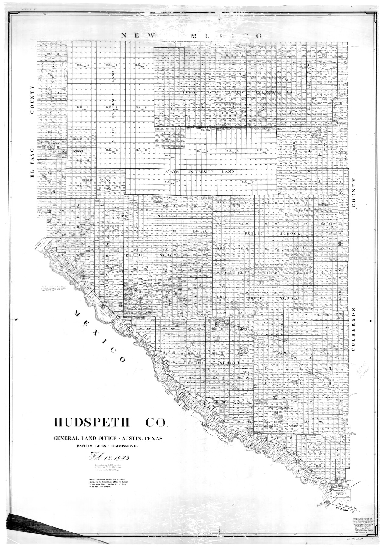
Hudspeth Co.
-
Map/Doc
77319
-
Collection
General Map Collection
-
Object Dates
2/18/1943 (Creation Date)
-
People and Organizations
Victor E. Sterzing (Draftsman)
G.C. Morriss (Compiler)
-
Counties
Hudspeth
-
Subjects
County
-
Height x Width
53.8 x 37.7 inches
136.7 x 95.8 cm
Part of: General Map Collection
Map of Hale County

Print $40.00
- Digital $50.00
Map of Hale County
1900
Size 49.3 x 41.0 inches
Map/Doc 4691
Midland County Rolled Sketch 5

Print $20.00
- Digital $50.00
Midland County Rolled Sketch 5
Size 35.3 x 44.8 inches
Map/Doc 10695
Edwards County Sketch File 56

Print $32.00
- Digital $50.00
Edwards County Sketch File 56
1915
Size 11.4 x 9.0 inches
Map/Doc 21808
Crockett County Working Sketch 99

Print $20.00
- Digital $50.00
Crockett County Working Sketch 99
1980
Size 37.1 x 34.5 inches
Map/Doc 68432
Webb County Sketch File 12-1

Print $16.00
- Digital $50.00
Webb County Sketch File 12-1
1886
Size 13.0 x 8.3 inches
Map/Doc 39793
Burnet County Sketch File 11

Print $40.00
- Digital $50.00
Burnet County Sketch File 11
1848
Size 12.8 x 15.2 inches
Map/Doc 16692
Delta County Working Sketch 4

Print $20.00
- Digital $50.00
Delta County Working Sketch 4
Size 16.8 x 21.1 inches
Map/Doc 62179
Presidio County Sketch File 99

Print $8.00
- Digital $50.00
Presidio County Sketch File 99
1955
Size 11.2 x 8.8 inches
Map/Doc 34787
[Sketch for Mineral Application 26501 - Sabine River, T. A. Oldhausen]
![2833, [Sketch for Mineral Application 26501 - Sabine River, T. A. Oldhausen], General Map Collection](https://historictexasmaps.com/wmedia_w700/maps/2833.tif.jpg)
Print $20.00
- Digital $50.00
[Sketch for Mineral Application 26501 - Sabine River, T. A. Oldhausen]
1931
Size 24.4 x 36.3 inches
Map/Doc 2833
Webb County Working Sketch 31

Print $20.00
- Digital $50.00
Webb County Working Sketch 31
1937
Size 23.2 x 26.0 inches
Map/Doc 72396
Hood County Sketch File 6

Print $4.00
- Digital $50.00
Hood County Sketch File 6
Size 7.2 x 6.1 inches
Map/Doc 26579
Atascosa County Sketch File 41a

Print $10.00
- Digital $50.00
Atascosa County Sketch File 41a
1956
Size 9.3 x 7.4 inches
Map/Doc 13841
You may also like
General Highway Map, El Paso County, Texas

Print $20.00
General Highway Map, El Paso County, Texas
1961
Size 18.1 x 24.5 inches
Map/Doc 79456
Graham's Addition Being a Subdivision of a Portion of Lot No. 1 of Spear League

Print $20.00
- Digital $50.00
Graham's Addition Being a Subdivision of a Portion of Lot No. 1 of Spear League
1914
Size 33.2 x 13.6 inches
Map/Doc 83426
Pecos County Rolled Sketch 142

Print $20.00
- Digital $50.00
Pecos County Rolled Sketch 142
Size 26.9 x 41.9 inches
Map/Doc 7276
Wichita County Sketch File 27

Print $52.00
- Digital $50.00
Wichita County Sketch File 27
1925
Size 9.1 x 7.9 inches
Map/Doc 40114
Limestone County Sketch File 24

Print $8.00
- Digital $50.00
Limestone County Sketch File 24
1942
Size 11.2 x 8.8 inches
Map/Doc 30206

Galveston Island

Print $20.00
- Digital $50.00
Galveston Island
1837
Size 24.1 x 37.2 inches
Map/Doc 2009
United States of North America (Eastern and Central)

Print $20.00
- Digital $50.00
United States of North America (Eastern and Central)
1862
Size 19.3 x 26.2 inches
Map/Doc 93667
Webb County Rolled Sketch 76

Print $20.00
- Digital $50.00
Webb County Rolled Sketch 76
1959
Size 32.8 x 44.0 inches
Map/Doc 10133
Panola County Working Sketch 36

Print $40.00
- Digital $50.00
Panola County Working Sketch 36
1984
Map/Doc 71445
Brazoria County Working Sketch 51

Print $20.00
- Digital $50.00
Brazoria County Working Sketch 51
2006
Size 34.0 x 38.0 inches
Map/Doc 83628
Gonzales County

Print $20.00
- Digital $50.00
Gonzales County
1853
Size 23.4 x 22.4 inches
Map/Doc 3591