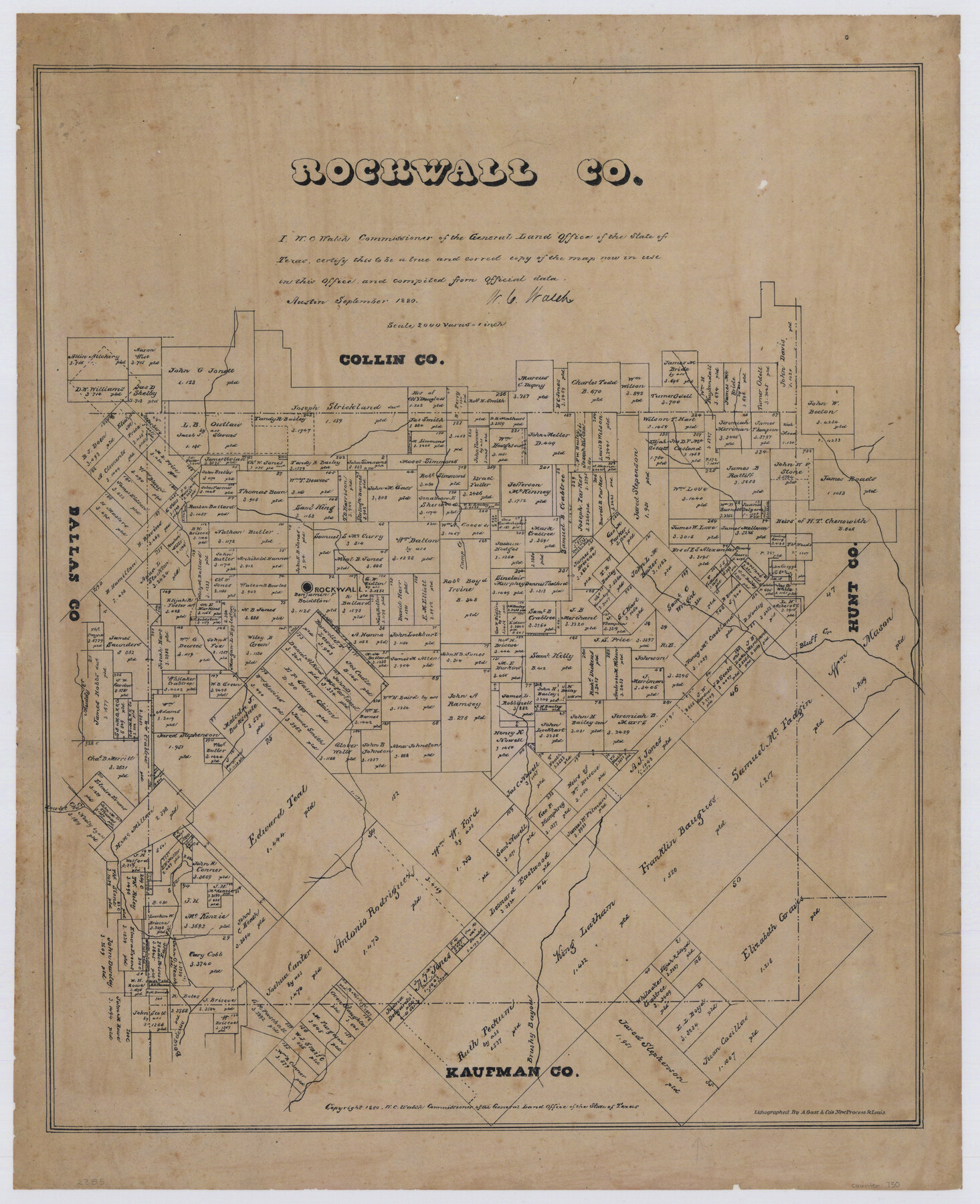
Rockwall County, Texas
-
Map/Doc
750
-
Collection
Maddox Collection
-
Object Dates
1880 (Creation Date)
1880 (Copyright Date)
-
People and Organizations
General Land Office (Publisher)
W.C. Walsh (GLO Commissioner)
August Gast & Co. (Lithographer)
-
Counties
Rockwall
-
Subjects
County
-
Height x Width
22.7 x 19.3 inches
57.7 x 49.0 cm
-
Medium
paper, etching/engraving/lithograph
-
Scale
1:2000
-
Comments
Conservation funded in 2002 with donation from Frost Bank
-
Features
Rockwall
Camp Creek
Bluff Creek
Muddy Creek
Rowlet Creek
Brushy Bayou
Bois dearc [sic] East F[ork]
Part of: Maddox Collection
Map of Orange County, Texas

Print $20.00
- Digital $50.00
Map of Orange County, Texas
1880
Size 15.6 x 19.1 inches
Map/Doc 746
[Surveying Sketch of Buckman, et al in Unknown County]
![498, [Surveying Sketch of Buckman, et al in Unknown County], Maddox Collection](https://historictexasmaps.com/wmedia_w700/maps/498.tif.jpg)
Print $3.00
- Digital $50.00
[Surveying Sketch of Buckman, et al in Unknown County]
Size 11.7 x 11.9 inches
Map/Doc 498
[Cemetary, Unknown Location]
![75552, [Cemetary, Unknown Location], Maddox Collection](https://historictexasmaps.com/wmedia_w700/maps/75552.tif.jpg)
Print $20.00
- Digital $50.00
[Cemetary, Unknown Location]
Size 30.6 x 14.9 inches
Map/Doc 75552
Red River County, Texas

Print $20.00
- Digital $50.00
Red River County, Texas
1879
Size 29.3 x 21.9 inches
Map/Doc 598
Map of Atascosa County, Texas

Print $20.00
- Digital $50.00
Map of Atascosa County, Texas
1879
Size 23.7 x 29.0 inches
Map/Doc 688
Sketch showing OX lands in the Yarbrough Pasture

Print $20.00
- Digital $50.00
Sketch showing OX lands in the Yarbrough Pasture
Size 14.0 x 25.2 inches
Map/Doc 4433
Austin, Texas - Congress Ave. Drainage

Print $20.00
- Digital $50.00
Austin, Texas - Congress Ave. Drainage
1905
Size 15.8 x 31.2 inches
Map/Doc 458
Map of Grimes County, Texas

Print $20.00
- Digital $50.00
Map of Grimes County, Texas
1880
Size 29.5 x 15.6 inches
Map/Doc 432
Martin County, Texas

Print $20.00
- Digital $50.00
Martin County, Texas
1870
Size 22.9 x 18.0 inches
Map/Doc 391
Map of Frio County, Texas

Print $20.00
- Digital $50.00
Map of Frio County, Texas
1879
Size 22.8 x 21.9 inches
Map/Doc 545
Map Showing the position of surveys 1 & 2, B.S. & F. Cert 1/356

Print $20.00
- Digital $50.00
Map Showing the position of surveys 1 & 2, B.S. & F. Cert 1/356
1915
Size 22.0 x 11.1 inches
Map/Doc 10768
Map of Wilson County, Texas

Print $20.00
- Digital $50.00
Map of Wilson County, Texas
1879
Size 22.9 x 24.8 inches
Map/Doc 674
You may also like
Upshur County Sketch File 13B

Print $20.00
- Digital $50.00
Upshur County Sketch File 13B
1936
Size 20.5 x 32.3 inches
Map/Doc 12504
Flight Mission No. BRA-7M, Frame 83, Jefferson County

Print $20.00
- Digital $50.00
Flight Mission No. BRA-7M, Frame 83, Jefferson County
1953
Size 16.1 x 16.1 inches
Map/Doc 85505
Loving County Working Sketch 26

Print $40.00
- Digital $50.00
Loving County Working Sketch 26
2014
Size 33.3 x 48.0 inches
Map/Doc 93681
Jefferson County NRC Article 33.136 Sketch 2

Print $20.00
- Digital $50.00
Jefferson County NRC Article 33.136 Sketch 2
2002
Size 24.3 x 35.9 inches
Map/Doc 77048
Working Sketch in Hutchinson County

Print $20.00
- Digital $50.00
Working Sketch in Hutchinson County
1922
Size 16.9 x 13.6 inches
Map/Doc 91251
Stonewall County

Print $20.00
- Digital $50.00
Stonewall County
1889
Size 19.6 x 24.3 inches
Map/Doc 91883

Original Town of Nadine, Lea County, New Mexico

Print $20.00
- Digital $50.00
Original Town of Nadine, Lea County, New Mexico
Size 27.1 x 33.5 inches
Map/Doc 92420
Hemphill County Sketch File 7

Print $20.00
- Digital $50.00
Hemphill County Sketch File 7
1924
Size 18.5 x 20.4 inches
Map/Doc 11753
[Nathaniel H. Cochran Survey and Vicinity]
![91497, [Nathaniel H. Cochran Survey and Vicinity], Twichell Survey Records](https://historictexasmaps.com/wmedia_w700/maps/91497-1.tif.jpg)
Print $20.00
- Digital $50.00
[Nathaniel H. Cochran Survey and Vicinity]
Size 25.5 x 18.8 inches
Map/Doc 91497
San Jacinto County Working Sketch 29
Print $20.00
- Digital $50.00
San Jacinto County Working Sketch 29
1950
Size 17.6 x 24.4 inches
Map/Doc 63742
Cass County Working Sketch 24

Print $20.00
- Digital $50.00
Cass County Working Sketch 24
1973
Size 35.6 x 27.7 inches
Map/Doc 67927