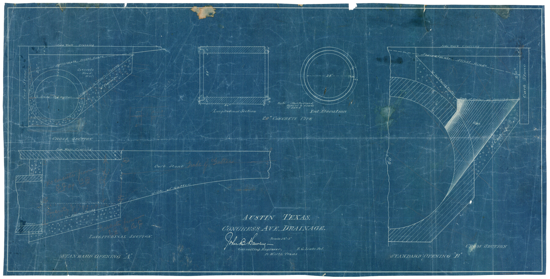
Austin, Texas - Congress Ave. Drainage
-
Map/Doc
458
-
Collection
Maddox Collection
-
Object Dates
[1905 ca.] (Creation Date)
-
People and Organizations
John B. Hawley (Author)
B.G. Leake (Draftsman)
-
Counties
Travis
-
Subjects
City
-
Height x Width
15.8 x 31.2 inches
40.1 x 79.3 cm
-
Comments
Conservation funded in 2005 by Friends of the Texas General Land Office.
Part of: Maddox Collection
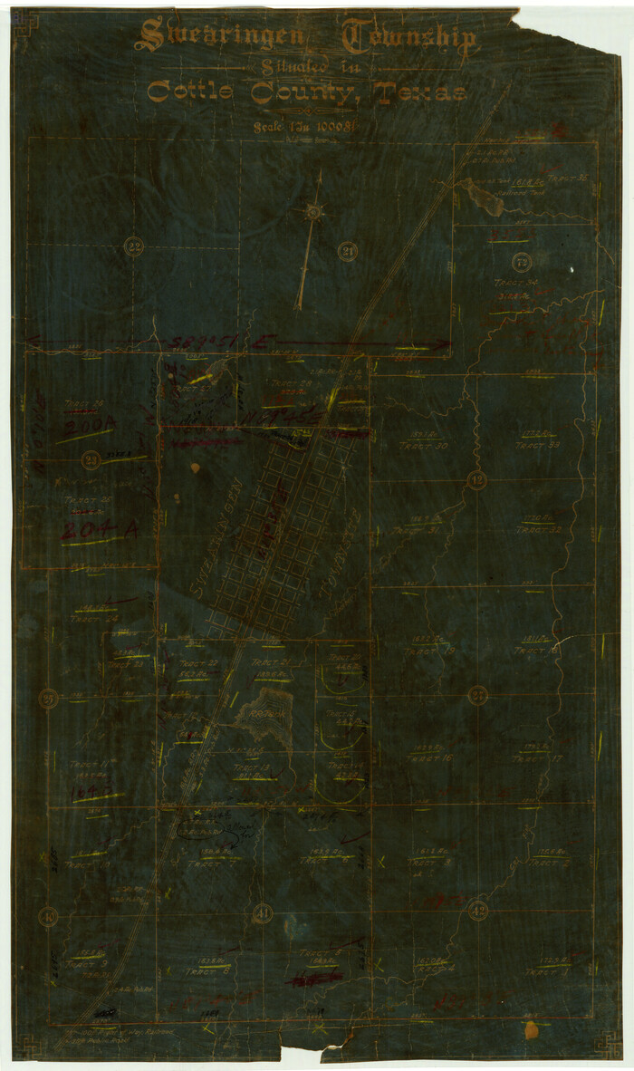
Swearingen Township situated in Cottle County, Texas
Print $20.00
- Digital $50.00
Swearingen Township situated in Cottle County, Texas
Size 26.4 x 15.7 inches
Map/Doc 4437
Cottle County, Texas

Print $20.00
- Digital $50.00
Cottle County, Texas
1891
Size 23.1 x 17.0 inches
Map/Doc 619
Trinity County, Texas

Print $20.00
- Digital $50.00
Trinity County, Texas
1879
Size 15.8 x 23.8 inches
Map/Doc 761
Map of Franklin County, Texas

Print $20.00
- Digital $50.00
Map of Franklin County, Texas
1879
Size 23.4 x 11.3 inches
Map/Doc 728
Map of Fisher & Miller's Colony made from the records in the office of the District Surveyor of Bexar comprising also all the recent surveys

Print $20.00
- Digital $50.00
Map of Fisher & Miller's Colony made from the records in the office of the District Surveyor of Bexar comprising also all the recent surveys
1855
Size 22.6 x 36.2 inches
Map/Doc 633
Map of Kendall County, Texas

Print $20.00
- Digital $50.00
Map of Kendall County, Texas
1879
Size 20.3 x 20.6 inches
Map/Doc 533
Map of Nacogdoches County, Texas

Print $20.00
- Digital $50.00
Map of Nacogdoches County, Texas
1881
Size 24.6 x 21.1 inches
Map/Doc 585
P.J. Lawless Addition of Part of Outlots 29 and 30, Division D, Austin, Texas.

Print $20.00
- Digital $50.00
P.J. Lawless Addition of Part of Outlots 29 and 30, Division D, Austin, Texas.
1916
Size 13.6 x 16.6 inches
Map/Doc 502
Plat of Surveys in Hidalgo Co.

Print $20.00
- Digital $50.00
Plat of Surveys in Hidalgo Co.
Size 17.3 x 8.4 inches
Map/Doc 75547
Map of Cherokee County, Texas

Print $20.00
- Digital $50.00
Map of Cherokee County, Texas
1879
Size 30.8 x 24.0 inches
Map/Doc 696
P.J. Lawless Addition of part of Outlots 29 and 30, Division D, Austin, Texas

Print $20.00
- Digital $50.00
P.J. Lawless Addition of part of Outlots 29 and 30, Division D, Austin, Texas
1916
Size 13.7 x 17.1 inches
Map/Doc 620
"La Gloria Ranch", Duval Co. Texas

Print $20.00
- Digital $50.00
"La Gloria Ranch", Duval Co. Texas
Size 12.0 x 15.1 inches
Map/Doc 431
You may also like
Brewster County Sketch File C-1

Print $14.00
- Digital $50.00
Brewster County Sketch File C-1
1911
Size 11.2 x 8.9 inches
Map/Doc 15719
Midland County Working Sketch 33

Print $20.00
- Digital $50.00
Midland County Working Sketch 33
1982
Size 38.2 x 36.2 inches
Map/Doc 71014
Angelina County Working Sketch 24

Print $20.00
- Digital $50.00
Angelina County Working Sketch 24
1954
Size 27.0 x 23.0 inches
Map/Doc 67106
Kaufman County Sketch File 11

Print $4.00
- Digital $50.00
Kaufman County Sketch File 11
1874
Size 10.2 x 8.4 inches
Map/Doc 28645
Flight Mission No. BRE-2P, Frame 68, Nueces County

Print $20.00
- Digital $50.00
Flight Mission No. BRE-2P, Frame 68, Nueces County
1956
Size 18.6 x 22.4 inches
Map/Doc 86763
Ward County Boundary File 3

Print $18.00
- Digital $50.00
Ward County Boundary File 3
Size 14.4 x 8.8 inches
Map/Doc 59675
Map of the route of B'vt. Maj. A. Moore's scout, April 11th to June 12th 1869

Print $20.00
Map of the route of B'vt. Maj. A. Moore's scout, April 11th to June 12th 1869
1872
Size 23.6 x 40.9 inches
Map/Doc 93566
[Surveys in the Bexar District along the Medina River]
![128, [Surveys in the Bexar District along the Medina River], General Map Collection](https://historictexasmaps.com/wmedia_w700/maps/128.tif.jpg)
Print $20.00
- Digital $50.00
[Surveys in the Bexar District along the Medina River]
1841
Size 23.0 x 16.8 inches
Map/Doc 128
Coleman County Sketch File 28

Print $6.00
- Digital $50.00
Coleman County Sketch File 28
1873
Size 10.2 x 15.8 inches
Map/Doc 18716
Crane County Sketch File 3b

Print $20.00
- Digital $50.00
Crane County Sketch File 3b
1881
Size 11.9 x 38.6 inches
Map/Doc 11206
Terrell County Sketch File 21

Print $13.00
- Digital $50.00
Terrell County Sketch File 21
1911
Size 16.4 x 10.3 inches
Map/Doc 37948
Liberty County Sketch File 57

Print $40.00
- Digital $50.00
Liberty County Sketch File 57
1928
Size 55.1 x 17.4 inches
Map/Doc 10523