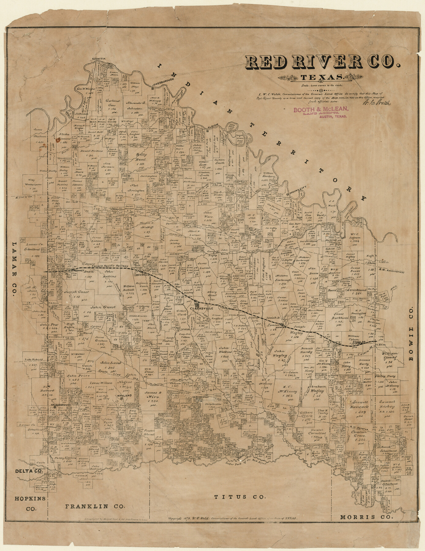
Red River County, Texas
-
Map/Doc
598
-
Collection
Maddox Collection
-
Object Dates
1879 (Creation Date)
-
People and Organizations
General Land Office (Publisher)
W.C. Walsh (GLO Commissioner)
August Gast & Co. (Lithographer)
-
Counties
Red River
-
Subjects
County
-
Height x Width
29.3 x 21.9 inches
74.4 x 55.6 cm
-
Medium
paper, etching/engraving/lithograph
-
Scale
1" = 4000 varas
-
Comments
Conservation funded in 2011 by Friends of the Texas General Land Office.
-
Features
Halesborough
Kicapoo [sic] Creek
Douglas
Shawney [sic] Village Creek
Heeltop Creek
Garvinsville
White Oak Creek
Slapham Creek
Baggy Creek
Cuthand Creek
Wayland
Annona
Big Mustang Creek
Little Mustang Creek
Maple Creek
Big Slough
Elm Creek
Caney Creek
Shawney [sic] Lake
Sulfur Fork of the Red River
Brushy Creek
Cedar Creek
White Oak Fork [of Pecan Bayou]
Jonesborough
Hasted's Lake
Pine Creek
Albion
Slingland Lake
Mound City
Mill Creek
Little Pine Creek
North Fork [of Pecan Bayou]
Pecan Bayou
Kiamitia
Little Creek
Clarksville
Bagwell
Bennet
Guest Creek
Cat Creek
Ward Creek
Bruton Creek
Bland Creek
Grugg Creek
Part of: Maddox Collection
Ochiltree County, Texas

Print $20.00
- Digital $50.00
Ochiltree County, Texas
1870
Size 21.4 x 19.7 inches
Map/Doc 507
Throckmorton County, Texas

Print $20.00
- Digital $50.00
Throckmorton County, Texas
1880
Size 28.8 x 22.5 inches
Map/Doc 627
[East half of Travis County]
![75802, [East half of Travis County], Maddox Collection](https://historictexasmaps.com/wmedia_w700/maps/75802.tif.jpg)
Print $20.00
- Digital $50.00
[East half of Travis County]
Size 42.5 x 29.8 inches
Map/Doc 75802
Castro County, Texas

Print $20.00
- Digital $50.00
Castro County, Texas
1883
Size 20.8 x 18.7 inches
Map/Doc 682
Map showing A. & N. W., Raymond Word #3, S.S. Hervey #496, and M. Farley #495 corrected to conform to the judgement in Cause #2888, Travis County District Court, State of Texas versus D. Sullivan, et al

Print $20.00
- Digital $50.00
Map showing A. & N. W., Raymond Word #3, S.S. Hervey #496, and M. Farley #495 corrected to conform to the judgement in Cause #2888, Travis County District Court, State of Texas versus D. Sullivan, et al
1915
Size 18.5 x 30.0 inches
Map/Doc 75812
Waller County, Texas

Print $20.00
- Digital $50.00
Waller County, Texas
1879
Size 22.8 x 17.7 inches
Map/Doc 764
Ector County, Texas

Print $20.00
- Digital $50.00
Ector County, Texas
1889
Size 23.9 x 19.4 inches
Map/Doc 608
[Working Sketch of a portion of Hidalgo & Starr Co's.]
![4447, [Working Sketch of a portion of Hidalgo & Starr Co's.], Maddox Collection](https://historictexasmaps.com/wmedia_w700/maps/4447.tif.jpg)
Print $20.00
- Digital $50.00
[Working Sketch of a portion of Hidalgo & Starr Co's.]
1906
Size 27.8 x 13.8 inches
Map/Doc 4447
[Surveying Sketch of Heirs of Wm Neil, J.J. Hall, Robert Sikes, et al in Hutchinson County, Texas]
![75778, [Surveying Sketch of Heirs of Wm Neil, J.J. Hall, Robert Sikes, et al in Hutchinson County, Texas], Maddox Collection](https://historictexasmaps.com/wmedia_w700/maps/75778-1.tif.jpg)
Print $20.00
- Digital $50.00
[Surveying Sketch of Heirs of Wm Neil, J.J. Hall, Robert Sikes, et al in Hutchinson County, Texas]
Size 15.6 x 20.5 inches
Map/Doc 75778
Survey of a Portion of Lot. No. 1 of Spear League

Print $20.00
- Digital $50.00
Survey of a Portion of Lot. No. 1 of Spear League
1911
Size 12.2 x 24.2 inches
Map/Doc 477
[Sketch Showing Surveys in Schleicher, Menard & Concho Counties, Texas]
![75782, [Sketch Showing Surveys in Schleicher, Menard & Concho Counties, Texas], Maddox Collection](https://historictexasmaps.com/wmedia_w700/maps/75782.tif.jpg)
Print $20.00
- Digital $50.00
[Sketch Showing Surveys in Schleicher, Menard & Concho Counties, Texas]
Size 16.1 x 28.9 inches
Map/Doc 75782
[Map of Townsite of Swearingen, Cottle County, Texas]
![4465, [Map of Townsite of Swearingen, Cottle County, Texas], Maddox Collection](https://historictexasmaps.com/wmedia_w700/maps/4465.tif.jpg)
Print $20.00
- Digital $50.00
[Map of Townsite of Swearingen, Cottle County, Texas]
Size 28.8 x 17.8 inches
Map/Doc 4465
You may also like
Cherokee County Sketch File 9

Print $8.00
- Digital $50.00
Cherokee County Sketch File 9
1853
Size 5.6 x 4.2 inches
Map/Doc 18132
Orange County Sketch File 40

Print $20.00
- Digital $50.00
Orange County Sketch File 40
1895
Size 18.2 x 22.7 inches
Map/Doc 12128
Tom Green County Rolled Sketch 26

Print $40.00
- Digital $50.00
Tom Green County Rolled Sketch 26
Size 40.0 x 48.3 inches
Map/Doc 10007
Duval County Rolled Sketch 44A

Print $40.00
- Digital $50.00
Duval County Rolled Sketch 44A
1981
Size 37.8 x 91.9 inches
Map/Doc 9062
The Judicial District/County of Guadalupe. Abolished, Spring 1842

Print $20.00
The Judicial District/County of Guadalupe. Abolished, Spring 1842
2020
Size 16.7 x 21.7 inches
Map/Doc 96328
Map of Armstrong County

Print $20.00
- Digital $50.00
Map of Armstrong County
1886
Size 23.0 x 18.6 inches
Map/Doc 3244
Right of Way and Track Map, The Missouri, Kansas and Texas Ry. of Texas operated by the Missouri, Kansas and Texas Ry. of Texas, Henrietta Division

Print $40.00
- Digital $50.00
Right of Way and Track Map, The Missouri, Kansas and Texas Ry. of Texas operated by the Missouri, Kansas and Texas Ry. of Texas, Henrietta Division
1918
Size 25.5 x 57.0 inches
Map/Doc 64071
Smith County Working Sketch 3

Print $20.00
- Digital $50.00
Smith County Working Sketch 3
Size 16.0 x 12.6 inches
Map/Doc 63888
[H. T. & B. Block 1 and area to the west]
![90923, [H. T. & B. Block 1 and area to the west], Twichell Survey Records](https://historictexasmaps.com/wmedia_w700/maps/90923-1.tif.jpg)
Print $20.00
- Digital $50.00
[H. T. & B. Block 1 and area to the west]
Size 33.5 x 36.6 inches
Map/Doc 90923
Copy of Surveyor's Field Book, Morris Browning - In Blocks 7, 5 & 4, I&GNRRCo., Hutchinson and Carson Counties, Texas

Print $2.00
- Digital $50.00
Copy of Surveyor's Field Book, Morris Browning - In Blocks 7, 5 & 4, I&GNRRCo., Hutchinson and Carson Counties, Texas
1888
Size 6.9 x 8.8 inches
Map/Doc 62280
Right of Way and Track Map Houston & Texas Central R.R. operated by the T. & N.O. R.R. Co., Austin Branch

Print $40.00
- Digital $50.00
Right of Way and Track Map Houston & Texas Central R.R. operated by the T. & N.O. R.R. Co., Austin Branch
1918
Size 26.0 x 58.4 inches
Map/Doc 64556
[Texas, New Mexico Clark's Monument #26]
![91309, [Texas, New Mexico Clark's Monument #26], Twichell Survey Records](https://historictexasmaps.com/wmedia_w700/maps/91309-1.tif.jpg)
Print $3.00
- Digital $50.00
[Texas, New Mexico Clark's Monument #26]
1941
Size 16.1 x 7.4 inches
Map/Doc 91309