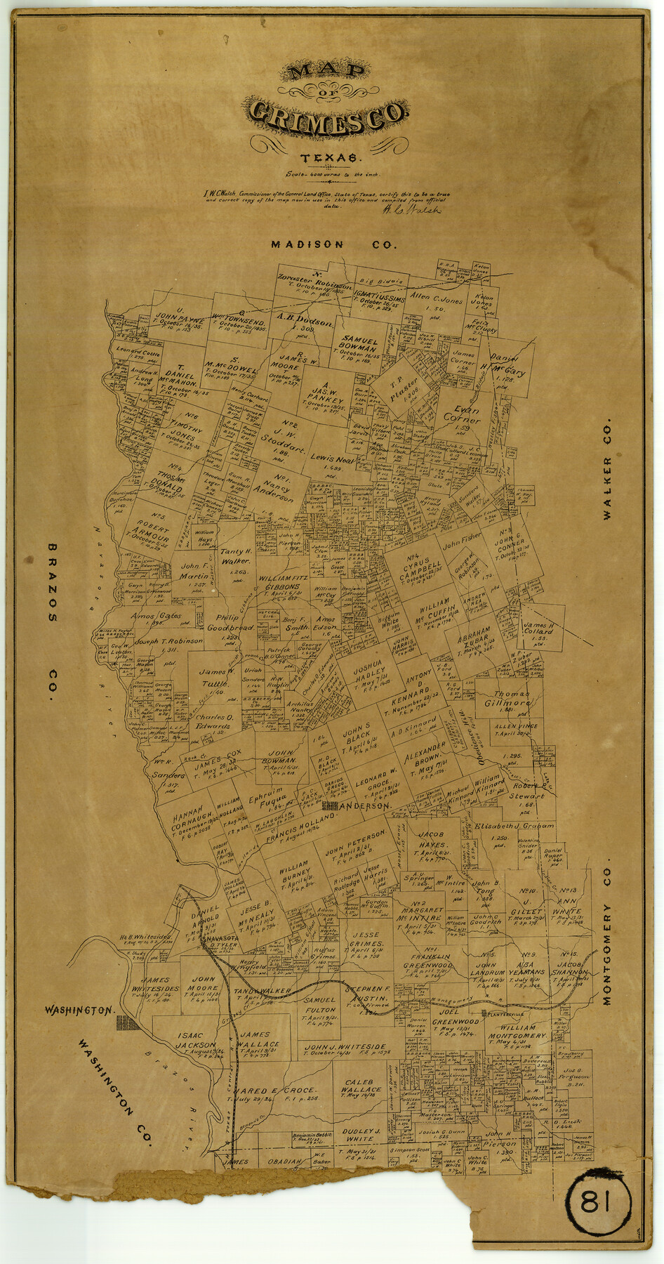
Map of Grimes County, Texas
-
Map/Doc
432
-
Collection
Maddox Collection
-
Object Dates
1880 (Creation Date)
-
People and Organizations
General Land Office (Publisher)
W.C. Walsh (GLO Commissioner)
-
Counties
Grimes
-
Subjects
County
-
Height x Width
29.5 x 15.6 inches
74.9 x 39.6 cm
-
Medium
paper, etching/engraving/lithograph
-
Scale
1:4000
-
Comments
Conservation funded in 2005 by Friends of the Texas General Land Office.
-
Features
Hollands Creek
H&TC
Beason's Creek
Brazos River
Washington
Grassy Creek
Montgomery Railroad
Plantersville
Indian Creek
Cedar Creek
Navasota
Smith Creek
Anderson
Garrett's Creek
Lake Creek
Rock Creek
Ben Fork [of] Smith Creek
Navasota River
Walker Creek
Gibbons Creek
South Bidais [Creek]
Big Bidais [Creek]
Part of: Maddox Collection
[Surveying sketch of S. Hayford, E. T. R.R. Co., T. C. R. R. Co., et al in Travis County, Texas]
![10753, [Surveying sketch of S. Hayford, E. T. R.R. Co., T. C. R. R. Co., et al in Travis County, Texas], Maddox Collection](https://historictexasmaps.com/wmedia_w700/maps/10753.tif.jpg)
Print $20.00
- Digital $50.00
[Surveying sketch of S. Hayford, E. T. R.R. Co., T. C. R. R. Co., et al in Travis County, Texas]
Size 18.0 x 17.3 inches
Map/Doc 10753
Map of the north west portion of Hutchinson County showing the proposed resurvey of Block M24

Print $20.00
- Digital $50.00
Map of the north west portion of Hutchinson County showing the proposed resurvey of Block M24
Size 29.1 x 31.9 inches
Map/Doc 75814
[Littlefield & White Survey, Kimble County, Texas]
![570, [Littlefield & White Survey, Kimble County, Texas], Maddox Collection](https://historictexasmaps.com/wmedia_w700/maps/0570.tif.jpg)
Print $20.00
- Digital $50.00
[Littlefield & White Survey, Kimble County, Texas]
Size 18.6 x 14.2 inches
Map/Doc 570
[Surveying Sketch of T. & N. O. R. R. Co., S. P. R. R. Co., E. T. R. R. Co., et al in Dallam, Hartley, Sherman & Moore Counties, Texas]
![75824, [Surveying Sketch of T. & N. O. R. R. Co., S. P. R. R. Co., E. T. R. R. Co., et al in Dallam, Hartley, Sherman & Moore Counties, Texas], Maddox Collection](https://historictexasmaps.com/wmedia_w700/maps/75824.tif.jpg)
Print $20.00
- Digital $50.00
[Surveying Sketch of T. & N. O. R. R. Co., S. P. R. R. Co., E. T. R. R. Co., et al in Dallam, Hartley, Sherman & Moore Counties, Texas]
Size 17.5 x 22.1 inches
Map/Doc 75824
Map of Bandera County, Texas

Print $20.00
- Digital $50.00
Map of Bandera County, Texas
1879
Size 19.6 x 32.6 inches
Map/Doc 691
Map of surveys 189 & 190, T. C. R.R. Co. in Travis County, Texas

Print $20.00
- Digital $50.00
Map of surveys 189 & 190, T. C. R.R. Co. in Travis County, Texas
1915
Size 18.5 x 25.0 inches
Map/Doc 75761
Sketch showing position of Asylum Lands Blk. 4, H. & T. C. R.R. Co. & river surveys on north side of Middle Concho, Tom Green Co.

Print $20.00
- Digital $50.00
Sketch showing position of Asylum Lands Blk. 4, H. & T. C. R.R. Co. & river surveys on north side of Middle Concho, Tom Green Co.
Size 14.4 x 20.6 inches
Map/Doc 388
[Wm. Lewis No. 254 and Surrounding Surveys, Aransas County, Texas]
![82557, [Wm. Lewis No. 254 and Surrounding Surveys, Aransas County, Texas], Maddox Collection](https://historictexasmaps.com/wmedia_w700/maps/82557.tif.jpg)
Print $20.00
- Digital $50.00
[Wm. Lewis No. 254 and Surrounding Surveys, Aransas County, Texas]
Size 18.8 x 35.2 inches
Map/Doc 82557
Map of Maverick County, Texas

Print $20.00
- Digital $50.00
Map of Maverick County, Texas
1879
Size 33.0 x 23.0 inches
Map/Doc 718
Map of Dewitt County, Texas

Print $20.00
- Digital $50.00
Map of Dewitt County, Texas
Size 22.8 x 27.6 inches
Map/Doc 706
Callahan County, Texas

Print $20.00
- Digital $50.00
Callahan County, Texas
1880
Size 24.1 x 18.5 inches
Map/Doc 89276
Map Showing the position of surveys 1 & 2, B.S. & F. Cert 1/356

Print $20.00
- Digital $50.00
Map Showing the position of surveys 1 & 2, B.S. & F. Cert 1/356
1915
Size 22.0 x 11.1 inches
Map/Doc 10768
You may also like
Hays County Sketch File 28

Print $20.00
- Digital $50.00
Hays County Sketch File 28
1912
Size 26.0 x 20.0 inches
Map/Doc 11750
Big Inch and Little Big Inch Pipelines

Big Inch and Little Big Inch Pipelines
2022
Size 8.5 x 11.0 inches
Map/Doc 97089

Brown County Sketch File 11

Print $4.00
- Digital $50.00
Brown County Sketch File 11
1859
Size 7.7 x 9.9 inches
Map/Doc 16597
Map of Texas Compiled from Surveys recorded in the Land Office of Texas

Print $20.00
- Digital $50.00
Map of Texas Compiled from Surveys recorded in the Land Office of Texas
1841
Size 26.4 x 22.3 inches
Map/Doc 538
Bandera County Sketch File 23

Print $40.00
- Digital $50.00
Bandera County Sketch File 23
1881
Size 16.1 x 13.7 inches
Map/Doc 10895
Runnels County Sketch File 6a

Print $4.00
Runnels County Sketch File 6a
1883
Size 12.9 x 8.2 inches
Map/Doc 35442
Hale County Sketch File 26

Print $40.00
- Digital $50.00
Hale County Sketch File 26
1911
Size 20.7 x 54.4 inches
Map/Doc 10471
[Surveying sketch of Dan'l. Dunham, O. de Santangelo, et al in Zavala County]
![708, [Surveying sketch of Dan'l. Dunham, O. de Santangelo, et al in Zavala County], Maddox Collection](https://historictexasmaps.com/wmedia_w700/maps/0708.tif.jpg)
Print $20.00
- Digital $50.00
[Surveying sketch of Dan'l. Dunham, O. de Santangelo, et al in Zavala County]
Size 16.2 x 16.0 inches
Map/Doc 708
Cass County Working Sketch 9

Print $20.00
- Digital $50.00
Cass County Working Sketch 9
1937
Size 28.4 x 32.7 inches
Map/Doc 67912
Fort Bend County Sketch File 3

Print $4.00
- Digital $50.00
Fort Bend County Sketch File 3
Size 12.8 x 8.1 inches
Map/Doc 22880
Limestone County Sketch File 16

Print $4.00
- Digital $50.00
Limestone County Sketch File 16
Size 12.8 x 8.3 inches
Map/Doc 30185