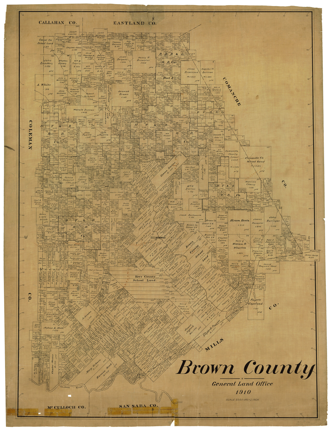
Brown County
-
Map/Doc
4895
-
Collection
General Map Collection
-
Object Dates
1910/5/27 (Creation Date)
-
People and Organizations
Texas General Land Office (Publisher)
H.F. McDonald (Compiler)
H.F. McDonald (Draftsman)
-
Counties
Brown
-
Subjects
County
-
Height x Width
49.3 x 37.5 inches
125.2 x 95.3 cm
Part of: General Map Collection
Township 14 South Range 15 West of the Louisiana Meridian, Louisiana

Print $20.00
- Digital $50.00
Township 14 South Range 15 West of the Louisiana Meridian, Louisiana
1875
Size 19.6 x 24.6 inches
Map/Doc 65859
East Part of Edwards County

Print $20.00
- Digital $50.00
East Part of Edwards County
1975
Size 39.7 x 28.5 inches
Map/Doc 77270
Pecos County Working Sketch 104

Print $40.00
- Digital $50.00
Pecos County Working Sketch 104
1971
Size 63.1 x 26.9 inches
Map/Doc 71577
Coryell County Working Sketch 25

Print $20.00
- Digital $50.00
Coryell County Working Sketch 25
1986
Size 22.2 x 29.4 inches
Map/Doc 68232
Map of The Surveyed Part of Peters Colony Texas

Print $40.00
- Digital $50.00
Map of The Surveyed Part of Peters Colony Texas
1852
Size 54.6 x 34.6 inches
Map/Doc 4654
Liberty County Rolled Sketch 12

Print $20.00
- Digital $50.00
Liberty County Rolled Sketch 12
1983
Size 26.5 x 22.6 inches
Map/Doc 6618
Harris County Sketch File 64

Print $40.00
- Digital $50.00
Harris County Sketch File 64
Size 16.3 x 14.1 inches
Map/Doc 25503
Grayson County Sketch File 27

Print $122.00
- Digital $50.00
Grayson County Sketch File 27
1875
Size 12.8 x 8.0 inches
Map/Doc 24510
Llano County Sketch File 8

Print $10.00
- Digital $50.00
Llano County Sketch File 8
1885
Size 14.1 x 8.8 inches
Map/Doc 30364

Crane County Working Sketch 14

Print $20.00
- Digital $50.00
Crane County Working Sketch 14
1946
Size 16.0 x 22.3 inches
Map/Doc 68291
Goliad County Sketch File 26a

Print $10.00
- Digital $50.00
Goliad County Sketch File 26a
Size 12.8 x 8.3 inches
Map/Doc 24321
You may also like
Burleson County

Print $20.00
- Digital $50.00
Burleson County
1920
Size 40.6 x 45.7 inches
Map/Doc 4896
Right-of-Way and Track Map, Texas State Railroad operated by the T. and N. O. R.R. Co.
Print $40.00
- Digital $50.00
Right-of-Way and Track Map, Texas State Railroad operated by the T. and N. O. R.R. Co.
1917
Size 24.8 x 56.3 inches
Map/Doc 64173
Water-Shed of the Brazos River

Print $40.00
- Digital $50.00
Water-Shed of the Brazos River
1925
Size 35.0 x 88.0 inches
Map/Doc 65263
Supplemental Plat, T. 4S., R. 14W., Indian Meridian, Oklahoma

Print $4.00
- Digital $50.00
Supplemental Plat, T. 4S., R. 14W., Indian Meridian, Oklahoma
1926
Size 18.1 x 23.6 inches
Map/Doc 75149
Anderson County Rolled Sketch 15

Print $20.00
- Digital $50.00
Anderson County Rolled Sketch 15
2002
Size 40.0 x 28.3 inches
Map/Doc 78315
Galveston County Rolled Sketch 11

Print $40.00
- Digital $50.00
Galveston County Rolled Sketch 11
1928
Size 29.7 x 169.5 inches
Map/Doc 9089
[Rio Grande & Eagle Pass - Stockdale to Cuero]
![64047, [Rio Grande & Eagle Pass - Stockdale to Cuero], General Map Collection](https://historictexasmaps.com/wmedia_w700/maps/64047.tif.jpg)
Print $40.00
- Digital $50.00
[Rio Grande & Eagle Pass - Stockdale to Cuero]
Size 20.6 x 121.5 inches
Map/Doc 64047
Map of Matagorda County

Print $20.00
- Digital $50.00
Map of Matagorda County
1865
Size 32.8 x 28.4 inches
Map/Doc 3843
Flight Mission No. BQR-4K, Frame 71, Brazoria County

Print $20.00
- Digital $50.00
Flight Mission No. BQR-4K, Frame 71, Brazoria County
1952
Size 18.8 x 22.4 inches
Map/Doc 84004

Flight Mission No. DAG-17K, Frame 63, Matagorda County

Print $20.00
- Digital $50.00
Flight Mission No. DAG-17K, Frame 63, Matagorda County
1952
Size 18.6 x 22.3 inches
Map/Doc 86325
[W. C. RR. Co. Blks. 1 & 2, I. & G. N. RR. Co. Blk. 1, in southeast part of County]
![90487, [W. C. RR. Co. Blks. 1 & 2, I. & G. N. RR. Co. Blk. 1, in southeast part of County], Twichell Survey Records](https://historictexasmaps.com/wmedia_w700/maps/90487-1.tif.jpg)
Print $2.00
- Digital $50.00
[W. C. RR. Co. Blks. 1 & 2, I. & G. N. RR. Co. Blk. 1, in southeast part of County]
1879
Size 6.5 x 5.8 inches
Map/Doc 90487