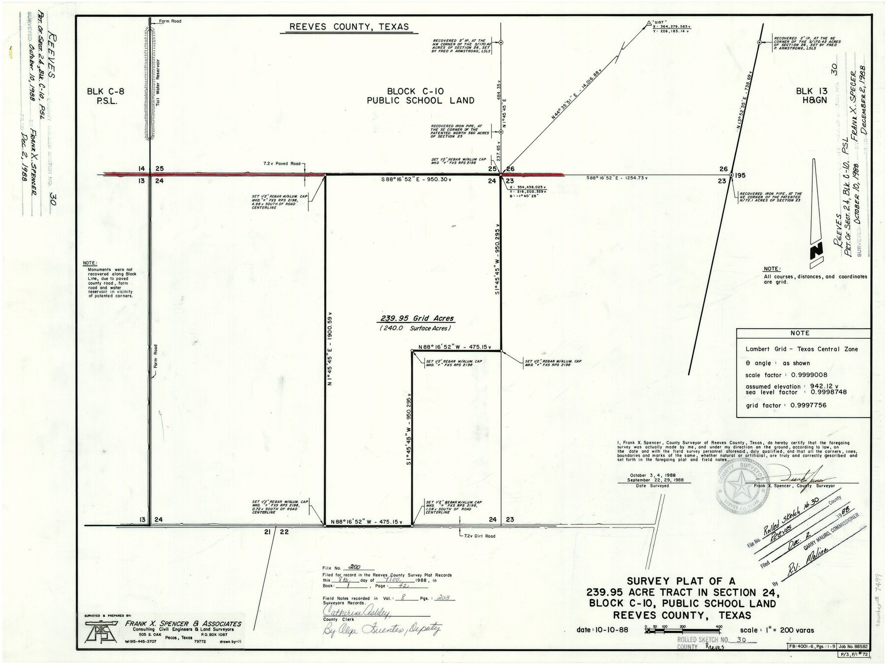
Reeves County Rolled Sketch 30
Survey plat of a 239.95 acre tract in section 24, Block C-10, Public School Land, Reeves County, Texas
-
Map/Doc
7499
-
Collection
General Map Collection
-
Object Dates
10/10/1988 (Creation Date)
12/2/1988 (File Date)
9/22, 9/29, 10/3, 10/4/1988 (Survey Date)
-
People and Organizations
Frank X. Spencer (Surveyor/Engineer)
-
Counties
Reeves
-
Subjects
Surveying Rolled Sketch
-
Height x Width
18.4 x 24.4 inches
46.7 x 62.0 cm
-
Medium
mylar, print
-
Scale
1" = 200 varas
Part of: General Map Collection
Gaines County Sketch File 17

Print $32.00
- Digital $50.00
Gaines County Sketch File 17
1962
Size 11.3 x 8.8 inches
Map/Doc 23204
Colored Map of Texas Gulf Coast from Sabine River to the Rio Grande

Print $20.00
- Digital $50.00
Colored Map of Texas Gulf Coast from Sabine River to the Rio Grande
1950
Size 44.7 x 43.0 inches
Map/Doc 3014
Crockett County Rolled Sketch 88E

Print $40.00
- Digital $50.00
Crockett County Rolled Sketch 88E
1973
Size 44.4 x 30.6 inches
Map/Doc 8730
Plan of the City of Austin

Print $40.00
- Digital $50.00
Plan of the City of Austin
1840
Size 54.0 x 38.9 inches
Map/Doc 2176
Flight Mission No. BQR-13K, Frame 21, Brazoria County

Print $20.00
- Digital $50.00
Flight Mission No. BQR-13K, Frame 21, Brazoria County
1952
Size 18.8 x 22.4 inches
Map/Doc 84069

Runnels County Rolled Sketch 1

Print $20.00
- Digital $50.00
Runnels County Rolled Sketch 1
1854
Size 28.0 x 18.4 inches
Map/Doc 75941
Concho County Sketch File 32

Print $20.00
- Digital $50.00
Concho County Sketch File 32
Size 29.6 x 26.7 inches
Map/Doc 11157
Topographical Map of the Rio Grande, Sheet No. 30

Print $20.00
- Digital $50.00
Topographical Map of the Rio Grande, Sheet No. 30
1912
Map/Doc 89554
Angelina County Sketch File 4

Print $4.00
- Digital $50.00
Angelina County Sketch File 4
1854
Size 8.3 x 9.0 inches
Map/Doc 12926
Polk County Rolled Sketch TMS

Print $40.00
- Digital $50.00
Polk County Rolled Sketch TMS
1937
Size 35.7 x 56.5 inches
Map/Doc 9756
Maverick County Working Sketch 10

Print $40.00
- Digital $50.00
Maverick County Working Sketch 10
1959
Size 52.9 x 39.1 inches
Map/Doc 70902
You may also like
Live Oak County Rolled Sketch 2

Print $20.00
- Digital $50.00
Live Oak County Rolled Sketch 2
1944
Size 34.1 x 26.6 inches
Map/Doc 6632
Hudspeth County Rolled Sketch 26

Print $20.00
- Digital $50.00
Hudspeth County Rolled Sketch 26
1909
Size 19.6 x 18.1 inches
Map/Doc 6246

Polk County Working Sketch 40

Print $20.00
- Digital $50.00
Polk County Working Sketch 40
1983
Size 25.4 x 27.3 inches
Map/Doc 71657
Township 2 North, Block 32]
![91211, Township 2 North, Block 32], Twichell Survey Records](https://historictexasmaps.com/wmedia_w700/maps/91211-1.tif.jpg)
Print $2.00
- Digital $50.00
Township 2 North, Block 32]
Size 9.0 x 13.7 inches
Map/Doc 91211
Political Essay on the Kingdom of New Spain Vol. 2, Third Edition

Political Essay on the Kingdom of New Spain Vol. 2, Third Edition
1822
Map/Doc 97387
Flight Mission No. BRA-8M, Frame 27, Jefferson County

Print $20.00
- Digital $50.00
Flight Mission No. BRA-8M, Frame 27, Jefferson County
1953
Size 18.6 x 22.3 inches
Map/Doc 85582
Burnet County Working Sketch 23

Print $40.00
- Digital $50.00
Burnet County Working Sketch 23
1987
Size 43.8 x 51.9 inches
Map/Doc 67866
Tyler County Sketch File A1

Print $22.00
- Digital $50.00
Tyler County Sketch File A1
Size 12.7 x 15.7 inches
Map/Doc 38605
McMullen County Working Sketch 13

Print $20.00
- Digital $50.00
McMullen County Working Sketch 13
1938
Size 27.2 x 21.6 inches
Map/Doc 70714
Map of Hamilton County

Print $20.00
Map of Hamilton County
1876
Size 19.0 x 22.2 inches
Map/Doc 88945
Galveston County NRC Article 33.136 Sketch 14

Print $20.00
- Digital $50.00
Galveston County NRC Article 33.136 Sketch 14
2002
Size 24.0 x 34.3 inches
Map/Doc 77045