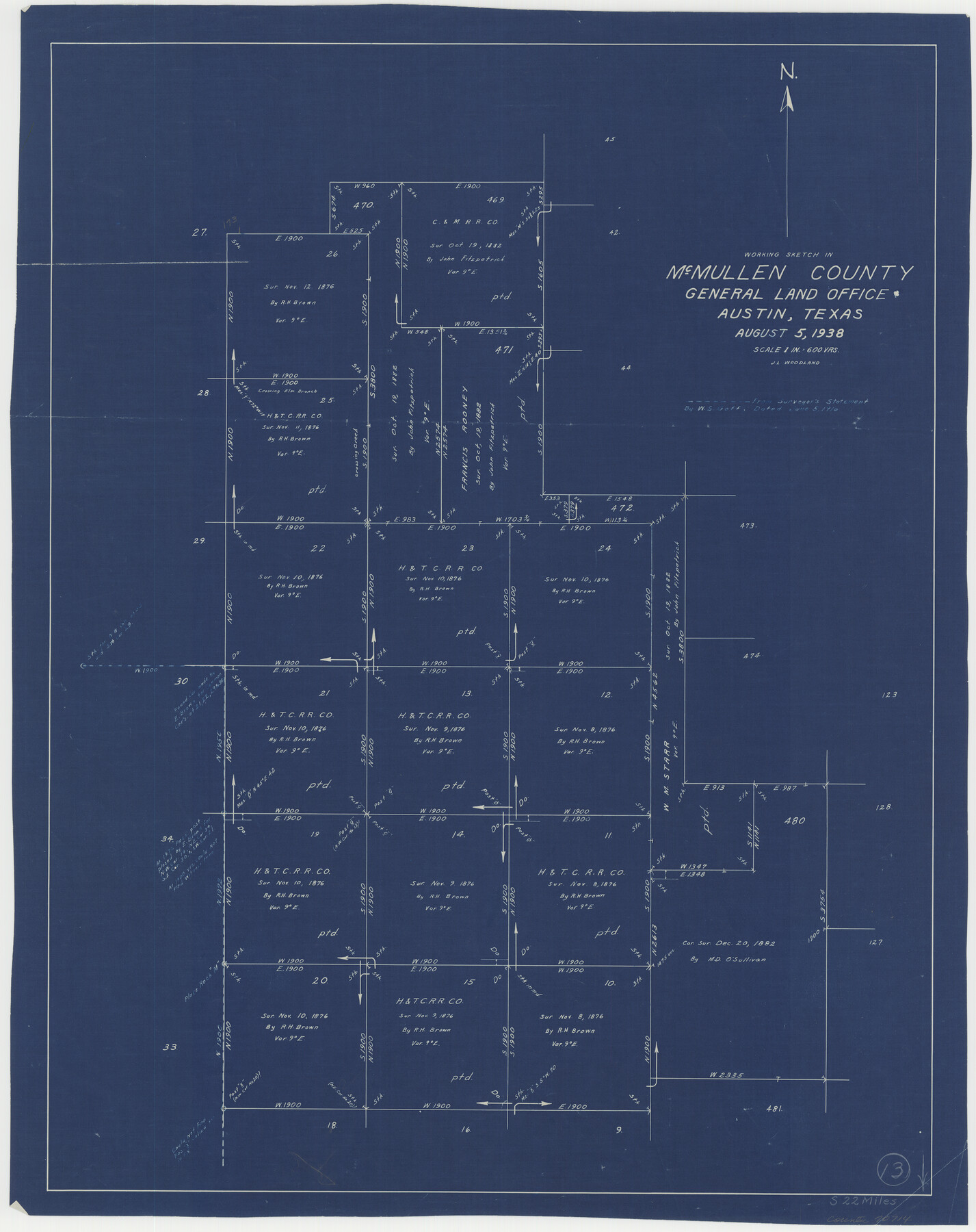
McMullen County Working Sketch 13
-
Map/Doc
70714
-
Collection
General Map Collection
-
Object Dates
8/5/1938 (Creation Date)
-
People and Organizations
J.L. Woodland (Draftsman)
-
Counties
McMullen
-
Subjects
Surveying Working Sketch
-
Height x Width
27.2 x 21.6 inches
69.1 x 54.9 cm
-
Scale
1" = 600 varas
Part of: General Map Collection
Borden County Working Sketch 6

Print $20.00
- Digital $50.00
Borden County Working Sketch 6
1944
Size 24.6 x 23.0 inches
Map/Doc 67466
Lipscomb County Sketch File 1

Print $40.00
- Digital $50.00
Lipscomb County Sketch File 1
Size 51.7 x 14.2 inches
Map/Doc 10525
Crane County Working Sketch 25

Print $20.00
- Digital $50.00
Crane County Working Sketch 25
1969
Size 33.0 x 26.3 inches
Map/Doc 68302
Starr County Rolled Sketch 11

Print $20.00
- Digital $50.00
Starr County Rolled Sketch 11
1912
Size 16.5 x 16.4 inches
Map/Doc 7798
Cameron County

Print $20.00
- Digital $50.00
Cameron County
1976
Size 31.0 x 38.3 inches
Map/Doc 95447
Orange County Rolled Sketch 33

Print $40.00
- Digital $50.00
Orange County Rolled Sketch 33
Size 58.4 x 50.1 inches
Map/Doc 9652
Presidio County Rolled Sketch 143

Print $20.00
- Digital $50.00
Presidio County Rolled Sketch 143
Size 40.2 x 36.8 inches
Map/Doc 90046
Comanche County Working Sketch 18

Print $20.00
- Digital $50.00
Comanche County Working Sketch 18
1973
Size 18.3 x 25.2 inches
Map/Doc 68152
Grayson County Working Sketch 5

Print $20.00
- Digital $50.00
Grayson County Working Sketch 5
1939
Size 28.4 x 40.6 inches
Map/Doc 63244

Map of a part of the North Portion of Harris County

Print $40.00
- Digital $50.00
Map of a part of the North Portion of Harris County
Size 34.5 x 57.0 inches
Map/Doc 2049
Pecos County Working Sketch 62

Print $40.00
- Digital $50.00
Pecos County Working Sketch 62
1952
Size 32.3 x 59.1 inches
Map/Doc 71534
You may also like
Burnet County Sketch File 28

Print $8.00
- Digital $50.00
Burnet County Sketch File 28
1874
Size 12.8 x 8.5 inches
Map/Doc 16740
Ector County Working Sketch 2

Print $20.00
- Digital $50.00
Ector County Working Sketch 2
1930
Size 33.1 x 38.2 inches
Map/Doc 68845
D No. 3 - Sketch of Ocracoke Inlet, North Carolina

Print $20.00
- Digital $50.00
D No. 3 - Sketch of Ocracoke Inlet, North Carolina
1852
Size 17.0 x 16.1 inches
Map/Doc 97210
Flight Mission No. CGI-3N, Frame 139, Cameron County

Print $20.00
- Digital $50.00
Flight Mission No. CGI-3N, Frame 139, Cameron County
1954
Size 18.7 x 22.3 inches
Map/Doc 84612

General Highway Map, Comanche County, Texas

Print $20.00
General Highway Map, Comanche County, Texas
1961
Size 24.7 x 18.2 inches
Map/Doc 79419
Cochran County, Texas

Print $20.00
- Digital $50.00
Cochran County, Texas
Size 29.8 x 37.5 inches
Map/Doc 92492
Flight Mission No. DIX-8P, Frame 88, Aransas County

Print $20.00
- Digital $50.00
Flight Mission No. DIX-8P, Frame 88, Aransas County
1956
Size 18.6 x 22.3 inches
Map/Doc 83913
General Highway Map, Robertson County, Texas

Print $20.00
General Highway Map, Robertson County, Texas
1940
Size 18.3 x 24.8 inches
Map/Doc 79230
[Jack District]
![1992, [Jack District], General Map Collection](https://historictexasmaps.com/wmedia_w700/maps/1992.tif.jpg)
Print $40.00
- Digital $50.00
[Jack District]
1880
Size 52.7 x 43.4 inches
Map/Doc 1992
[Surveys near the Medina River, Bexar District]
![230, [Surveys near the Medina River, Bexar District], General Map Collection](https://historictexasmaps.com/wmedia_w700/maps/230.tif.jpg)
Print $2.00
- Digital $50.00
[Surveys near the Medina River, Bexar District]
1847
Size 13.1 x 8.0 inches
Map/Doc 230
Presidio County Sketch File 64a

Print $4.00
- Digital $50.00
Presidio County Sketch File 64a
1939
Size 11.3 x 8.8 inches
Map/Doc 34652