Real County Rolled Sketch 5
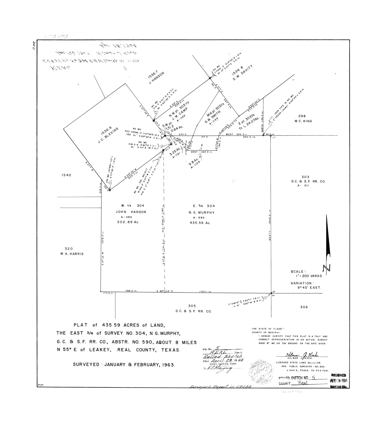
Plat of 435.59 acres of land, the east 3/4 of survey no. 304, N.G. Murphy, G. C. & S. F. R.R. Co., abstr. no.-590
-
Map/Doc
7455
-
Collection
General Map Collection
-
Object Dates
1963 (Survey Date)
1964/4/28 (File Date)
-
People and Organizations
Hilmar J. Koch (Surveyor/Engineer)
-
Counties
Real
-
Subjects
Surveying Rolled Sketch
-
Height x Width
26.2 x 23.7 inches
66.5 x 60.2 cm
-
Medium
mylar, print
-
Scale
1" = 200 varas
-
Comments
See surveyor's report in School file 68424.
Part of: General Map Collection
Andrews County Rolled Sketch 20

Print $20.00
- Digital $50.00
Andrews County Rolled Sketch 20
Size 31.6 x 40.0 inches
Map/Doc 8395
Bosque County Sketch File 30

Print $6.00
- Digital $50.00
Bosque County Sketch File 30
Size 7.6 x 7.6 inches
Map/Doc 14819
Leon County Rolled Sketch 9

Print $40.00
- Digital $50.00
Leon County Rolled Sketch 9
1960
Size 50.1 x 35.2 inches
Map/Doc 9430
Brewster County Rolled Sketch 101

Print $40.00
- Digital $50.00
Brewster County Rolled Sketch 101
1927
Size 74.2 x 42.3 inches
Map/Doc 9192
South Part Brewster Co.

Print $40.00
- Digital $50.00
South Part Brewster Co.
1915
Size 36.0 x 51.2 inches
Map/Doc 66733
Erath County Sketch File A

Print $4.00
- Digital $50.00
Erath County Sketch File A
Size 8.6 x 11.0 inches
Map/Doc 22249
Flight Mission No. BRE-5P, Frame 192, Nueces County

Print $20.00
- Digital $50.00
Flight Mission No. BRE-5P, Frame 192, Nueces County
1956
Size 18.4 x 22.3 inches
Map/Doc 86838
Armstrong County Sketch File 4a

Print $4.00
- Digital $50.00
Armstrong County Sketch File 4a
1883
Size 14.3 x 8.9 inches
Map/Doc 13687
Brewster County Working Sketch 38

Print $20.00
- Digital $50.00
Brewster County Working Sketch 38
1944
Size 36.3 x 28.4 inches
Map/Doc 67572
Comal County Sketch File 16

Print $4.00
- Digital $50.00
Comal County Sketch File 16
1878
Size 8.4 x 10.7 inches
Map/Doc 19034
Map of the United States constructed from the latest authorities

Print $20.00
- Digital $50.00
Map of the United States constructed from the latest authorities
1825
Size 19.4 x 24.5 inches
Map/Doc 93924
University Land Block 46, Culberson County, Texas

Print $20.00
- Digital $50.00
University Land Block 46, Culberson County, Texas
1938
Size 35.1 x 22.0 inches
Map/Doc 2410
You may also like
"The Texas and Pacific Railway Company Reservation and Land Grant"

Print $38.00
- Digital $50.00
"The Texas and Pacific Railway Company Reservation and Land Grant"
1962
Size 9.3 x 6.5 inches
Map/Doc 62213
Hardeman County Rolled Sketch 19

Print $52.00
- Digital $50.00
Hardeman County Rolled Sketch 19
1927
Size 30.9 x 31.5 inches
Map/Doc 9109
Harris County Historic Topographic A

Print $20.00
- Digital $50.00
Harris County Historic Topographic A
1916
Size 26.1 x 19.0 inches
Map/Doc 65849
General Highway Map Cochran County, Texas

Print $20.00
- Digital $50.00
General Highway Map Cochran County, Texas
1948
Size 18.7 x 25.6 inches
Map/Doc 92498
Map of Irion County

Print $20.00
- Digital $50.00
Map of Irion County
1893
Size 43.6 x 37.3 inches
Map/Doc 16857
Lynn County Sketch File A

Print $2.00
- Digital $50.00
Lynn County Sketch File A
1905
Size 8.6 x 6.3 inches
Map/Doc 30477
Maverick County Sketch File 9

Print $8.00
- Digital $50.00
Maverick County Sketch File 9
1878
Size 5.3 x 5.6 inches
Map/Doc 31068
Township 6 North Range 14 West, North Western District, Louisiana

Print $20.00
- Digital $50.00
Township 6 North Range 14 West, North Western District, Louisiana
1841
Size 19.5 x 24.7 inches
Map/Doc 65863
Map of Denton County

Print $20.00
- Digital $50.00
Map of Denton County
1897
Size 43.4 x 40.2 inches
Map/Doc 4720
Dallam County

Print $20.00
- Digital $50.00
Dallam County
1888
Size 29.5 x 24.6 inches
Map/Doc 90654
Brewster County Rolled Sketch 110

Print $20.00
- Digital $50.00
Brewster County Rolled Sketch 110
1961
Size 19.7 x 37.7 inches
Map/Doc 5262
Matagorda County

Print $40.00
- Digital $50.00
Matagorda County
1920
Size 39.7 x 49.1 inches
Map/Doc 77368