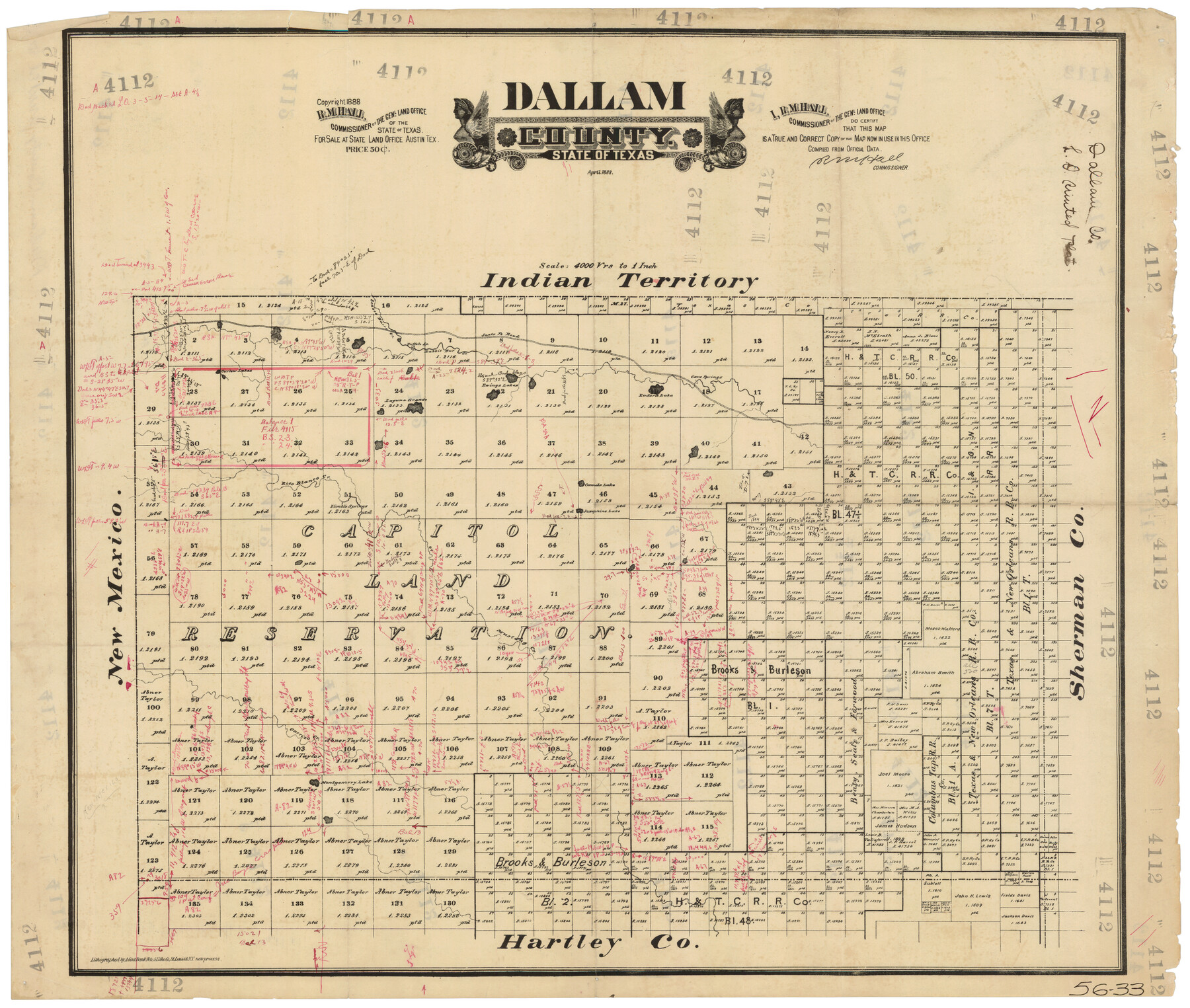
Dallam County
56-33
-
Map/Doc
90654
-
Collection
Twichell Survey Records
-
Object Dates
4/1888 (Creation Date)
-
Counties
Dallam
-
Subjects
County
-
Height x Width
29.5 x 24.6 inches
74.9 x 62.5 cm
Part of: Twichell Survey Records
[Part of T. & N. O. RR. Co Block 2 and area around Jasper Hays survey]
![90850, [Part of T. & N. O. RR. Co Block 2 and area around Jasper Hays survey], Twichell Survey Records](https://historictexasmaps.com/wmedia_w700/maps/90850-2.tif.jpg)
Print $20.00
- Digital $50.00
[Part of T. & N. O. RR. Co Block 2 and area around Jasper Hays survey]
1907
Size 13.3 x 28.4 inches
Map/Doc 90850
[Township 5-S, Blocks 36, 37 & 38]
![92291, [Township 5-S, Blocks 36, 37 & 38], Twichell Survey Records](https://historictexasmaps.com/wmedia_w700/maps/92291-1.tif.jpg)
Print $20.00
- Digital $50.00
[Township 5-S, Blocks 36, 37 & 38]
1952
Size 27.6 x 26.5 inches
Map/Doc 92291

Brazos River Conservation and Reclamation District Official Boundary Line Survey, Parmer County

Print $20.00
- Digital $50.00
Brazos River Conservation and Reclamation District Official Boundary Line Survey, Parmer County
Size 24.6 x 16.8 inches
Map/Doc 91657
Famous Heights Addition to Amarillo, Potter Co. Texas

Print $20.00
- Digital $50.00
Famous Heights Addition to Amarillo, Potter Co. Texas
Size 18.6 x 10.0 inches
Map/Doc 91744
Northeastern Half of Pecos County - Ownership Map

Print $40.00
- Digital $50.00
Northeastern Half of Pecos County - Ownership Map
Size 92.7 x 37.2 inches
Map/Doc 93197
Highland Place an Addition to City of Lubbock

Print $20.00
- Digital $50.00
Highland Place an Addition to City of Lubbock
Size 25.9 x 22.1 inches
Map/Doc 92844
Sheet 2 copied from Champlin Book 5 [Strip Map showing T. & P. connecting lines]
![93178, Sheet 2 copied from Champlin Book 5 [Strip Map showing T. & P. connecting lines], Twichell Survey Records](https://historictexasmaps.com/wmedia_w700/maps/93178-1.tif.jpg)
Print $40.00
- Digital $50.00
Sheet 2 copied from Champlin Book 5 [Strip Map showing T. & P. connecting lines]
1909
Size 7.3 x 70.3 inches
Map/Doc 93178
Texas State Capitol Land

Print $40.00
- Digital $50.00
Texas State Capitol Land
1915
Size 76.5 x 55.6 inches
Map/Doc 93155
Eberstadt and Brock's Subdivisions of the West Half of Survey 187 Block 2 A. B. & M., Randall County Texas

Print $20.00
- Digital $50.00
Eberstadt and Brock's Subdivisions of the West Half of Survey 187 Block 2 A. B. & M., Randall County Texas
Size 17.7 x 29.6 inches
Map/Doc 91748
Working Sketch in Pecos Co. [now Val Verde and Terrell Counties] / [Connecting Lines]
![91865, Working Sketch in Pecos Co. [now Val Verde and Terrell Counties] / [Connecting Lines], Twichell Survey Records](https://historictexasmaps.com/wmedia_w700/maps/91865-1.tif.jpg)
Print $20.00
- Digital $50.00
Working Sketch in Pecos Co. [now Val Verde and Terrell Counties] / [Connecting Lines]
Size 18.6 x 24.3 inches
Map/Doc 91865
Del Mar Addition

Print $20.00
- Digital $50.00
Del Mar Addition
Size 29.4 x 13.4 inches
Map/Doc 92789
You may also like
Midland County Working Sketch 1

Print $20.00
- Digital $50.00
Midland County Working Sketch 1
Size 26.8 x 8.7 inches
Map/Doc 70981
Land Owned by the Cedar Valley Land and Cattle Co. are M.K.O.

Print $20.00
- Digital $50.00
Land Owned by the Cedar Valley Land and Cattle Co. are M.K.O.
Size 21.4 x 16.5 inches
Map/Doc 91758
Wood County Working Sketch 15

Print $20.00
- Digital $50.00
Wood County Working Sketch 15
1981
Size 25.7 x 31.7 inches
Map/Doc 62015
Starr County Rolled Sketch 24

Print $20.00
- Digital $50.00
Starr County Rolled Sketch 24
1938
Size 37.5 x 26.7 inches
Map/Doc 7808
Southern Homes in Southern Texas, The Celebrated Coast Country

Southern Homes in Southern Texas, The Celebrated Coast Country
1899
Size 6.2 x 3.7 inches
Map/Doc 97050
El Paso County Rolled Sketch 43B

Print $20.00
- Digital $50.00
El Paso County Rolled Sketch 43B
Size 22.0 x 22.0 inches
Map/Doc 5830
Brewster County Rolled Sketch 118

Print $20.00
- Digital $50.00
Brewster County Rolled Sketch 118
1971
Size 25.3 x 37.2 inches
Map/Doc 5295
Refugio County Boundary File 4

Print $28.00
- Digital $50.00
Refugio County Boundary File 4
Size 14.0 x 8.8 inches
Map/Doc 58251
Flight Mission No. DQO-7K, Frame 74, Galveston County

Print $20.00
- Digital $50.00
Flight Mission No. DQO-7K, Frame 74, Galveston County
1952
Size 18.9 x 22.5 inches
Map/Doc 85101
Texas Panhandle East Boundary Line

Print $40.00
- Digital $50.00
Texas Panhandle East Boundary Line
Size 66.1 x 9.3 inches
Map/Doc 65380
Collingsworth County

Print $20.00
- Digital $50.00
Collingsworth County
1892
Size 26.5 x 20.8 inches
Map/Doc 66759
Pecos County Working Sketch 91b

Print $40.00
- Digital $50.00
Pecos County Working Sketch 91b
1965
Size 78.9 x 32.7 inches
Map/Doc 71564