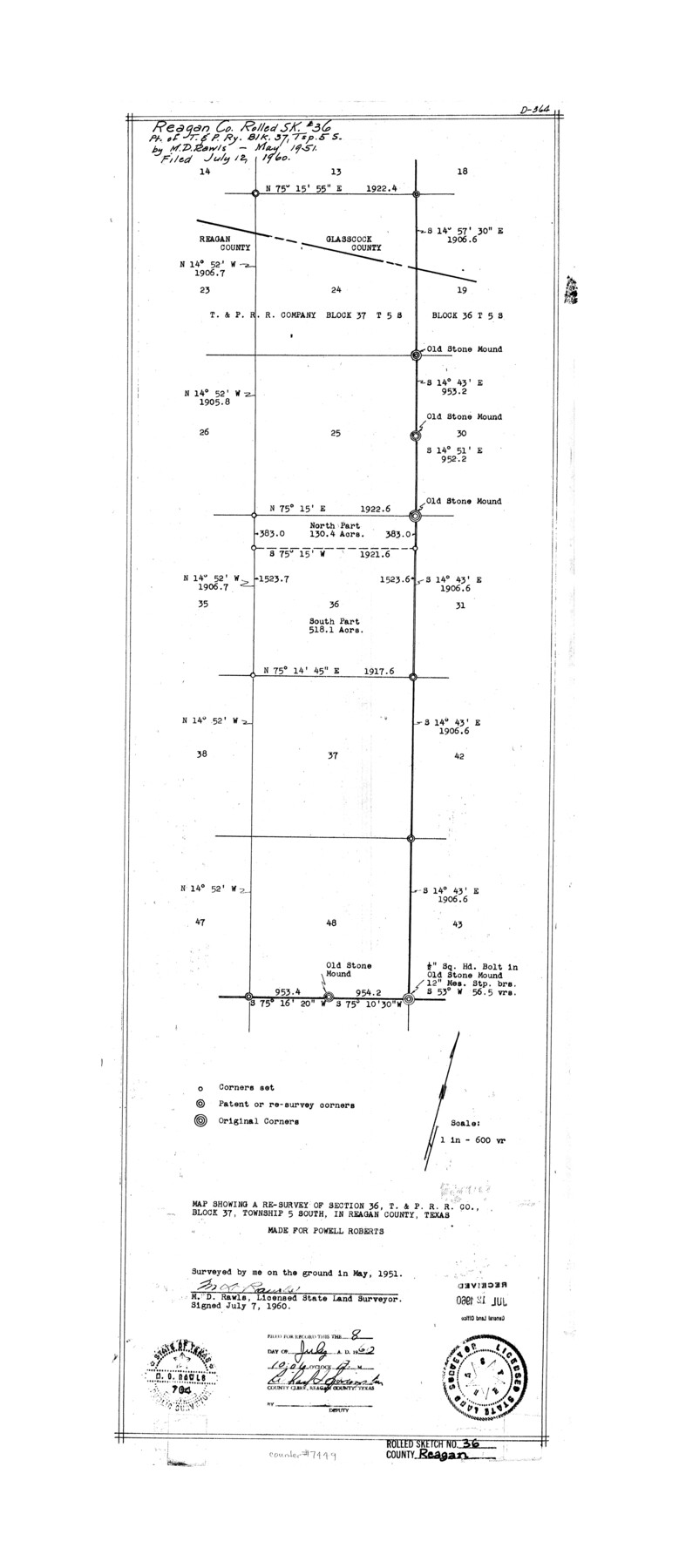
Reagan County Rolled Sketch 36
Map showing a re-survey of section 36, T. & P. R.R. Co. Block 37, Township 5 South, in Reagan County, Texas made for Powell Roberts
-
Map/Doc
7449
-
Collection
General Map Collection
-
Object Dates
1951 (Survey Date)
1960/7/12 (File Date)
1960/7/7 (Creation Date)
-
People and Organizations
M.D. Rawls (Surveyor/Engineer)
-
Counties
Reagan Glasscock
-
Subjects
Surveying Rolled Sketch
-
Height x Width
31.0 x 13.4 inches
78.7 x 34.0 cm
-
Medium
mylar, print
-
Scale
1" = 600 varas
-
Comments
See Reagan County Sketch File 34 (35030) for correspondence.
Related maps
Reagan County Sketch File 34

Print $4.00
- Digital $50.00
Reagan County Sketch File 34
Size 11.5 x 8.9 inches
Map/Doc 35030
Part of: General Map Collection
Map of Anderson County

Print $20.00
- Digital $50.00
Map of Anderson County
1895
Size 40.9 x 45.4 inches
Map/Doc 4784
Flight Mission No. DCL-7C, Frame 67, Kenedy County

Print $20.00
- Digital $50.00
Flight Mission No. DCL-7C, Frame 67, Kenedy County
1943
Size 15.5 x 15.3 inches
Map/Doc 86053
Presidio County Sketch File 31

Print $20.00
- Digital $50.00
Presidio County Sketch File 31
Size 11.4 x 20.8 inches
Map/Doc 11712
Field notes for subdivisions of University Leagues/Surveys in Fannin, Grayson, McLennan, Hunt, Lamar, Collin, and Cooke Counties

Field notes for subdivisions of University Leagues/Surveys in Fannin, Grayson, McLennan, Hunt, Lamar, Collin, and Cooke Counties
Map/Doc 81727
Maps of Gulf Intracoastal Waterway, Texas - Sabine River to the Rio Grande and connecting waterways including ship channels

Print $20.00
- Digital $50.00
Maps of Gulf Intracoastal Waterway, Texas - Sabine River to the Rio Grande and connecting waterways including ship channels
1966
Size 14.5 x 22.3 inches
Map/Doc 61948
Tom Green County Rolled Sketch 48

Print $20.00
- Digital $50.00
Tom Green County Rolled Sketch 48
1884
Size 14.3 x 22.7 inches
Map/Doc 8009
Runnels County Rolled Sketch 45

Print $20.00
- Digital $50.00
Runnels County Rolled Sketch 45
1954
Size 32.1 x 41.0 inches
Map/Doc 7532
San Jacinto River and Tributaries, Texas - Survey of 1939

Print $20.00
- Digital $50.00
San Jacinto River and Tributaries, Texas - Survey of 1939
1939
Size 27.7 x 40.4 inches
Map/Doc 60309
Crane County Working Sketch Graphic Index, Sheet B

Print $20.00
- Digital $50.00
Crane County Working Sketch Graphic Index, Sheet B
1945
Size 44.8 x 33.6 inches
Map/Doc 76508
La Salle County Sketch File 29a

Print $22.00
- Digital $50.00
La Salle County Sketch File 29a
1886
Size 8.9 x 12.5 inches
Map/Doc 29563
Yoakum County Sketch File 2

Print $6.00
- Digital $50.00
Yoakum County Sketch File 2
1892
Size 14.5 x 8.5 inches
Map/Doc 40702
Williamson County Working Sketch 4

Print $20.00
- Digital $50.00
Williamson County Working Sketch 4
1919
Size 23.7 x 19.4 inches
Map/Doc 72564
You may also like
Harrison County Sketch File 3

Print $8.00
- Digital $50.00
Harrison County Sketch File 3
Size 13.0 x 8.3 inches
Map/Doc 26036
McMullen County Working Sketch 6

Print $20.00
- Digital $50.00
McMullen County Working Sketch 6
1926
Size 24.5 x 22.9 inches
Map/Doc 70707
Culberson County Working Sketch 35

Print $20.00
- Digital $50.00
Culberson County Working Sketch 35
1963
Size 23.6 x 24.0 inches
Map/Doc 68488
Wharton County Sketch File 13

Print $26.00
- Digital $50.00
Wharton County Sketch File 13
1894
Size 14.0 x 8.7 inches
Map/Doc 39935
Wharton County Working Sketch 4

Print $20.00
- Digital $50.00
Wharton County Working Sketch 4
Size 16.3 x 21.3 inches
Map/Doc 72468
Wilson County Boundary File 2

Print $10.00
- Digital $50.00
Wilson County Boundary File 2
Size 12.3 x 8.3 inches
Map/Doc 60078
General Chart of the Coast No. XVI - Gulf Coast from Galveston to the Rio Grande

Print $20.00
- Digital $50.00
General Chart of the Coast No. XVI - Gulf Coast from Galveston to the Rio Grande
1883
Size 26.8 x 18.1 inches
Map/Doc 72737
Comanche County Sketch File 24 1/2

Print $6.00
- Digital $50.00
Comanche County Sketch File 24 1/2
Size 10.5 x 15.8 inches
Map/Doc 19113
Flight Mission No. BRA-16M, Frame 145, Jefferson County

Print $20.00
- Digital $50.00
Flight Mission No. BRA-16M, Frame 145, Jefferson County
1953
Size 18.7 x 22.3 inches
Map/Doc 85751
Edwards County Working Sketch 35

Print $20.00
- Digital $50.00
Edwards County Working Sketch 35
1948
Size 20.9 x 31.1 inches
Map/Doc 68911
Flight Mission No. BRA-7M, Frame 151, Jefferson County

Print $20.00
- Digital $50.00
Flight Mission No. BRA-7M, Frame 151, Jefferson County
1953
Size 18.7 x 22.6 inches
Map/Doc 85545
Map of the Roman Empire to illustrate Ancient History, engraved for Olney's school atlas

Print $20.00
- Digital $50.00
Map of the Roman Empire to illustrate Ancient History, engraved for Olney's school atlas
1845
Size 12.1 x 19.0 inches
Map/Doc 93550