Wharton County Sketch File 13
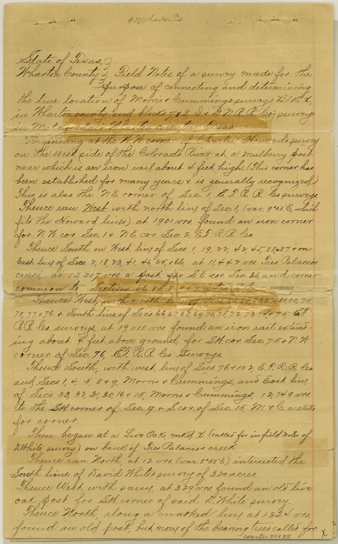
[Field notes and sketch of a survey made for the purpose of connecting and determining the true location of Morris & Cummings Block X surveys and I. & G. N. Ry. Co. Blocks 7 and 8 surveys]
-
Map/Doc
39935
-
Collection
General Map Collection
-
Object Dates
6/30/1894 (Creation Date)
7/2/1894 (File Date)
6/22/1894 (Survey Date)
-
People and Organizations
F.J. Hardey (Surveyor/Engineer)
-
Counties
Wharton Jackson Matagorda
-
Subjects
Surveying Sketch File
-
Height x Width
14.0 x 8.7 inches
35.6 x 22.1 cm
-
Medium
paper, manuscript
-
Features
Tres Palacios Creek
Twin Basins
Blue Creek
East Carancahua Creek
West Fork of Carancahua Creek
Part of: General Map Collection
San Patricio County Rolled Sketch 32

Print $20.00
- Digital $50.00
San Patricio County Rolled Sketch 32
1948
Size 38.8 x 25.0 inches
Map/Doc 7583
Edwards County Working Sketch 25

Print $20.00
- Digital $50.00
Edwards County Working Sketch 25
1942
Size 22.6 x 20.8 inches
Map/Doc 68901
San Jacinto County Working Sketch 37

Print $20.00
- Digital $50.00
San Jacinto County Working Sketch 37
1965
Size 32.7 x 42.6 inches
Map/Doc 63750
Amistad International Reservoir on Rio Grande 91

Print $20.00
- Digital $50.00
Amistad International Reservoir on Rio Grande 91
1950
Size 28.5 x 41.0 inches
Map/Doc 75521
Aransas County Sketch File 7

Print $4.00
- Digital $50.00
Aransas County Sketch File 7
Size 12.7 x 7.9 inches
Map/Doc 13112
United States - Gulf Coast - From Latitude 26° 33' to the Rio Grande Texas

Print $20.00
- Digital $50.00
United States - Gulf Coast - From Latitude 26° 33' to the Rio Grande Texas
1918
Size 18.3 x 24.1 inches
Map/Doc 72845
Flight Mission No. DCL-7C, Frame 67, Kenedy County

Print $20.00
- Digital $50.00
Flight Mission No. DCL-7C, Frame 67, Kenedy County
1943
Size 15.5 x 15.3 inches
Map/Doc 86053
Flight Mission No. BRA-8M, Frame 135, Jefferson County

Print $20.00
- Digital $50.00
Flight Mission No. BRA-8M, Frame 135, Jefferson County
1953
Size 18.7 x 22.3 inches
Map/Doc 85631
Midland County Working Sketch 28

Print $20.00
- Digital $50.00
Midland County Working Sketch 28
1968
Size 29.7 x 31.7 inches
Map/Doc 71009
Presidio County Working Sketch 27

Print $20.00
- Digital $50.00
Presidio County Working Sketch 27
1945
Size 32.4 x 13.4 inches
Map/Doc 71703
Presidio County Working Sketch 32

Print $40.00
- Digital $50.00
Presidio County Working Sketch 32
1946
Size 26.1 x 50.6 inches
Map/Doc 71709
Hemphill County Working Sketch 35

Print $20.00
- Digital $50.00
Hemphill County Working Sketch 35
1978
Size 35.9 x 44.8 inches
Map/Doc 66130
You may also like
Map of Young County

Print $20.00
- Digital $50.00
Map of Young County
1880
Size 22.0 x 20.3 inches
Map/Doc 4174
[I. G. Yates survey and adjacent area south of Runnels County School Land]
![91679, [I. G. Yates survey and adjacent area south of Runnels County School Land], Twichell Survey Records](https://historictexasmaps.com/wmedia_w700/maps/91679-1.tif.jpg)
Print $20.00
- Digital $50.00
[I. G. Yates survey and adjacent area south of Runnels County School Land]
Size 15.1 x 14.5 inches
Map/Doc 91679

[Lgs. 192-195, 176-179]
![90254, [Lgs. 192-195, 176-179], Twichell Survey Records](https://historictexasmaps.com/wmedia_w700/maps/90254-1.tif.jpg)
Print $20.00
- Digital $50.00
[Lgs. 192-195, 176-179]
Size 18.2 x 25.2 inches
Map/Doc 90254

The Republic County of Harrison. December 31, 1844

Print $20.00
The Republic County of Harrison. December 31, 1844
2020
Size 18.6 x 21.7 inches
Map/Doc 96176
Map of Haskell County Young District

Print $20.00
- Digital $50.00
Map of Haskell County Young District
1859
Size 21.9 x 25.8 inches
Map/Doc 3641
[Sketch for Mineral Application 27669 - Trinity River, Frank R. Graves]
![2858, [Sketch for Mineral Application 27669 - Trinity River, Frank R. Graves], General Map Collection](https://historictexasmaps.com/wmedia_w700/maps/2858-1.tif.jpg)
Print $40.00
- Digital $50.00
[Sketch for Mineral Application 27669 - Trinity River, Frank R. Graves]
1934
Size 28.3 x 83.2 inches
Map/Doc 2858
Presidio County Working Sketch 15

Print $20.00
- Digital $50.00
Presidio County Working Sketch 15
1942
Size 38.1 x 41.3 inches
Map/Doc 71691

Located Line of the Panhandle & Gulf Ry. through State Lands, Public School and University in Irion County, Texas

Print $20.00
- Digital $50.00
Located Line of the Panhandle & Gulf Ry. through State Lands, Public School and University in Irion County, Texas
1904
Size 12.1 x 27.5 inches
Map/Doc 64145
[Part of Bexar District]
![1958, [Part of Bexar District], General Map Collection](https://historictexasmaps.com/wmedia_w700/maps/1958-1.tif.jpg)
Print $20.00
- Digital $50.00
[Part of Bexar District]
1847
Size 40.9 x 27.8 inches
Map/Doc 1958