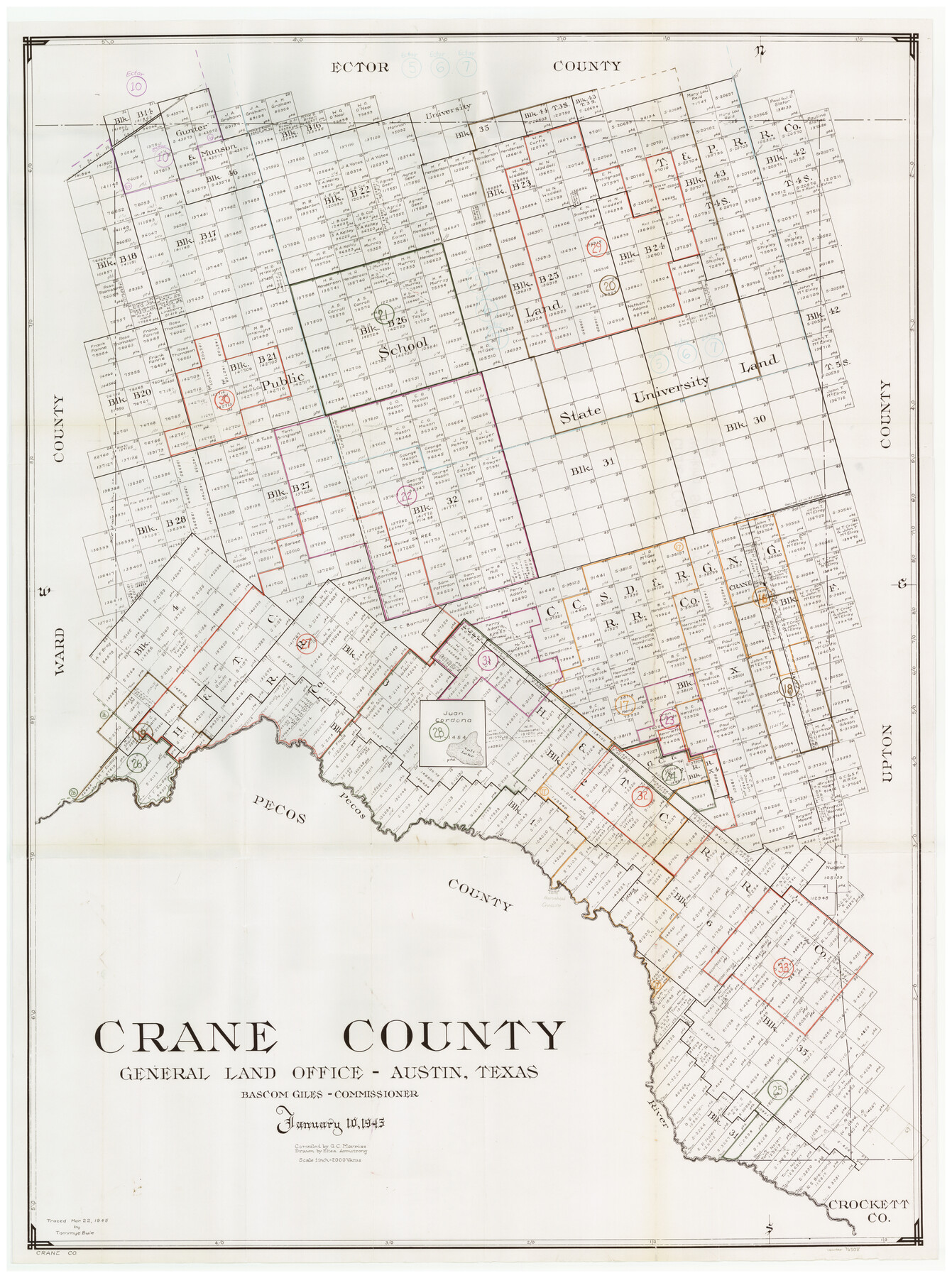
Crane County Working Sketch Graphic Index, Sheet B
-
Map/Doc
76508
-
Collection
General Map Collection
-
Object Dates
1/10/1945 (Creation Date)
-
People and Organizations
G.C. Morriss (Compiler)
Eltea Armstrong (Draftsman)
Tommye Buie (Tracer)
-
Counties
Crane
-
Subjects
County Surveying Working Sketch
-
Height x Width
44.8 x 33.6 inches
113.8 x 85.3 cm
-
Scale
1" = 2000 varas
Part of: General Map Collection
Aransas County Sketch File 31

Print $46.00
- Digital $50.00
Aransas County Sketch File 31
1919
Size 14.2 x 8.7 inches
Map/Doc 13274
Delta County Working Sketch Graphic Index

Print $20.00
- Digital $50.00
Delta County Working Sketch Graphic Index
1942
Size 25.3 x 39.2 inches
Map/Doc 76520
Burleson County Working Sketch 32

Print $20.00
- Digital $50.00
Burleson County Working Sketch 32
1981
Size 26.3 x 13.5 inches
Map/Doc 67751
Brewster County Working Sketch 117

Print $20.00
- Digital $50.00
Brewster County Working Sketch 117
1988
Size 33.3 x 37.0 inches
Map/Doc 67717
Taylor County Working Sketch 11

Print $20.00
- Digital $50.00
Taylor County Working Sketch 11
1956
Size 23.0 x 24.4 inches
Map/Doc 69621
Hamilton County Sketch File A

Print $4.00
- Digital $50.00
Hamilton County Sketch File A
1879
Size 9.1 x 8.2 inches
Map/Doc 24948
Aransas County Rolled Sketch 35

Print $40.00
- Digital $50.00
Aransas County Rolled Sketch 35
2006
Size 37.5 x 50.0 inches
Map/Doc 83555
Dickens County Sketch File 27

Print $25.00
- Digital $50.00
Dickens County Sketch File 27
Size 14.4 x 8.9 inches
Map/Doc 20993
Dallas County Sketch File 18

Print $6.00
- Digital $50.00
Dallas County Sketch File 18
1871
Size 15.8 x 11.0 inches
Map/Doc 20437
Hudspeth County Rolled Sketch 45

Print $20.00
- Digital $50.00
Hudspeth County Rolled Sketch 45
1958
Size 20.5 x 35.6 inches
Map/Doc 6254
Culberson County Sketch File 32

Print $22.00
- Digital $50.00
Culberson County Sketch File 32
1952
Size 11.2 x 8.7 inches
Map/Doc 20285
Crockett County Sketch File 72

Print $14.00
- Digital $50.00
Crockett County Sketch File 72
Size 14.0 x 8.6 inches
Map/Doc 19862
You may also like
Reagan County Working Sketch 49

Print $20.00
- Digital $50.00
Reagan County Working Sketch 49
1990
Size 40.4 x 25.2 inches
Map/Doc 71892
Upton County Working Sketch 39

Print $20.00
- Digital $50.00
Upton County Working Sketch 39
1958
Size 25.4 x 30.1 inches
Map/Doc 69535
Palo Pinto County Working Sketch 7

Print $20.00
- Digital $50.00
Palo Pinto County Working Sketch 7
1922
Map/Doc 71390
Fayette County Boundary File 5

Print $59.00
- Digital $50.00
Fayette County Boundary File 5
Size 14.4 x 9.0 inches
Map/Doc 53371
Tarrant County Working Sketch 23

Print $20.00
- Digital $50.00
Tarrant County Working Sketch 23
2001
Size 15.9 x 15.6 inches
Map/Doc 62440
Erath County Working Sketch 42

Print $20.00
- Digital $50.00
Erath County Working Sketch 42
1981
Size 23.0 x 23.6 inches
Map/Doc 69123
[Right of Way and Track Map, the Missouri, Kansas and Texas Ry. of Texas - Henrietta Division]
![64758, [Right of Way and Track Map, the Missouri, Kansas and Texas Ry. of Texas - Henrietta Division], General Map Collection](https://historictexasmaps.com/wmedia_w700/maps/64758.tif.jpg)
Print $20.00
- Digital $50.00
[Right of Way and Track Map, the Missouri, Kansas and Texas Ry. of Texas - Henrietta Division]
1918
Size 11.8 x 26.8 inches
Map/Doc 64758
Hall County Sketch File D

Print $8.00
- Digital $50.00
Hall County Sketch File D
1906
Size 14.4 x 8.7 inches
Map/Doc 24792
Revised Map of West Half of Sabine Lake, Jefferson & Orange Cos., showing subdivision for mineral development

Print $40.00
- Digital $50.00
Revised Map of West Half of Sabine Lake, Jefferson & Orange Cos., showing subdivision for mineral development
1957
Size 58.9 x 42.0 inches
Map/Doc 2898
Liberty County Rolled Sketch JP2

Print $40.00
- Digital $50.00
Liberty County Rolled Sketch JP2
1935
Size 52.0 x 12.5 inches
Map/Doc 9568
Red River County Sketch File 5a

Print $2.00
- Digital $50.00
Red River County Sketch File 5a
Size 4.7 x 6.6 inches
Map/Doc 35104
Pecos County Working Sketch 51

Print $20.00
- Digital $50.00
Pecos County Working Sketch 51
1948
Size 22.5 x 21.9 inches
Map/Doc 71523