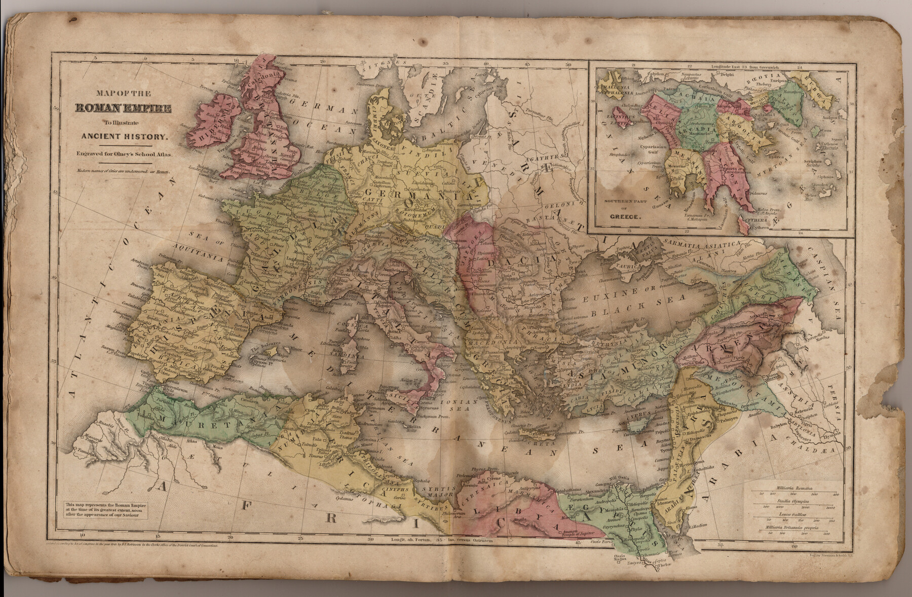
Map of the Roman Empire to illustrate Ancient History, engraved for Olney's school atlas
-
Map/Doc
93550
-
Collection
General Map Collection
-
Object Dates
1845 (Creation Date)
2013/7/12 (File Date)
-
People and Organizations
Pratt, Woodford and Co. (Publisher)
Sherman and Smith (Printer)
Galen Greaser (Donor)
J. Olney (Author)
-
Subjects
Atlas Curiosities
-
Height x Width
12.1 x 19.0 inches
30.7 x 48.3 cm
-
Comments
Donated by Galen Greaser in 2009. Map is part of volume: "Olney's School Atlas". See 93534 for a PDF of this complete atlas.
Related maps
Olney's School Atlas

Print $326.00
- Digital $50.00
Olney's School Atlas
1844
Size 12.3 x 10.0 inches
Map/Doc 93534
Part of: General Map Collection
Hutchinson County Rolled Sketch 38

Print $40.00
- Digital $50.00
Hutchinson County Rolled Sketch 38
1955
Size 43.6 x 67.7 inches
Map/Doc 9248
Dickens County Sketch File B

Print $4.00
- Digital $50.00
Dickens County Sketch File B
1894
Size 14.2 x 8.8 inches
Map/Doc 20831
Hudspeth County Rolled Sketch 70

Print $40.00
- Digital $50.00
Hudspeth County Rolled Sketch 70
1982
Size 38.1 x 47.7 inches
Map/Doc 9233
Red River County Working Sketch 16

Print $20.00
- Digital $50.00
Red River County Working Sketch 16
1953
Size 21.8 x 23.4 inches
Map/Doc 71999
Brazos River, Harlem-Imperial Farms Project

Print $20.00
- Digital $50.00
Brazos River, Harlem-Imperial Farms Project
1930
Size 28.3 x 25.5 inches
Map/Doc 69678
Kimble County Boundary File 4

Print $26.00
- Digital $50.00
Kimble County Boundary File 4
Size 7.5 x 7.3 inches
Map/Doc 64868
Brewster County Rolled Sketch 57

Print $20.00
- Digital $50.00
Brewster County Rolled Sketch 57
1937
Size 43.1 x 37.8 inches
Map/Doc 8482
Presidio County Working Sketch 130

Print $20.00
- Digital $50.00
Presidio County Working Sketch 130
1989
Size 22.1 x 43.1 inches
Map/Doc 71808
Fannin County Working Sketch 8

Print $20.00
- Digital $50.00
Fannin County Working Sketch 8
1955
Size 27.2 x 16.0 inches
Map/Doc 69162
Crosby County Sketch File 10

Print $12.00
- Digital $50.00
Crosby County Sketch File 10
1887
Size 12.8 x 8.2 inches
Map/Doc 20011
Gonzales County Working Sketch 3

Print $20.00
- Digital $50.00
Gonzales County Working Sketch 3
1943
Size 37.8 x 41.5 inches
Map/Doc 63218
Houston Ship Channel

Print $20.00
- Digital $50.00
Houston Ship Channel
1926
Size 32.9 x 38.3 inches
Map/Doc 69893
You may also like
Galveston County NRC Article 33.136 Sketch 70

Print $24.00
- Digital $50.00
Galveston County NRC Article 33.136 Sketch 70
2012
Size 24.0 x 24.3 inches
Map/Doc 95111
America sive novvs orbis respectv evropaeorvm inferior globi terrestris pars 1596

Print $20.00
- Digital $50.00
America sive novvs orbis respectv evropaeorvm inferior globi terrestris pars 1596
1596
Size 14.7 x 18.1 inches
Map/Doc 93809
Bee County Sketch File 11

Print $40.00
- Digital $50.00
Bee County Sketch File 11
Size 20.8 x 25.0 inches
Map/Doc 10915
Flight Mission No. DQN-5K, Frame 141, Calhoun County

Print $20.00
- Digital $50.00
Flight Mission No. DQN-5K, Frame 141, Calhoun County
1953
Size 18.7 x 21.9 inches
Map/Doc 84416
The Judicial District/County of Trinity. Created, December 7, 1841

Print $20.00
The Judicial District/County of Trinity. Created, December 7, 1841
2020
Size 14.7 x 21.7 inches
Map/Doc 96350
R. S. Dod Meanders

Print $20.00
- Digital $50.00
R. S. Dod Meanders
Size 19.0 x 13.2 inches
Map/Doc 91675
Baylor County Boundary File 6

Print $82.00
- Digital $50.00
Baylor County Boundary File 6
Size 9.5 x 65.3 inches
Map/Doc 50400
Medina County Working Sketch 30

Print $20.00
- Digital $50.00
Medina County Working Sketch 30
1992
Size 19.2 x 15.4 inches
Map/Doc 70945
Coke County Rolled Sketch 14B

Print $20.00
- Digital $50.00
Coke County Rolled Sketch 14B
Size 16.3 x 19.3 inches
Map/Doc 5516
Dickens County Sketch File J

Print $12.00
- Digital $50.00
Dickens County Sketch File J
1904
Size 11.6 x 9.1 inches
Map/Doc 20883
Terrell County Working Sketch 26

Print $20.00
- Digital $50.00
Terrell County Working Sketch 26
1943
Size 17.5 x 14.0 inches
Map/Doc 62176
Hutchinson County Working Sketch 38

Print $20.00
- Digital $50.00
Hutchinson County Working Sketch 38
1978
Size 27.2 x 22.5 inches
Map/Doc 66398