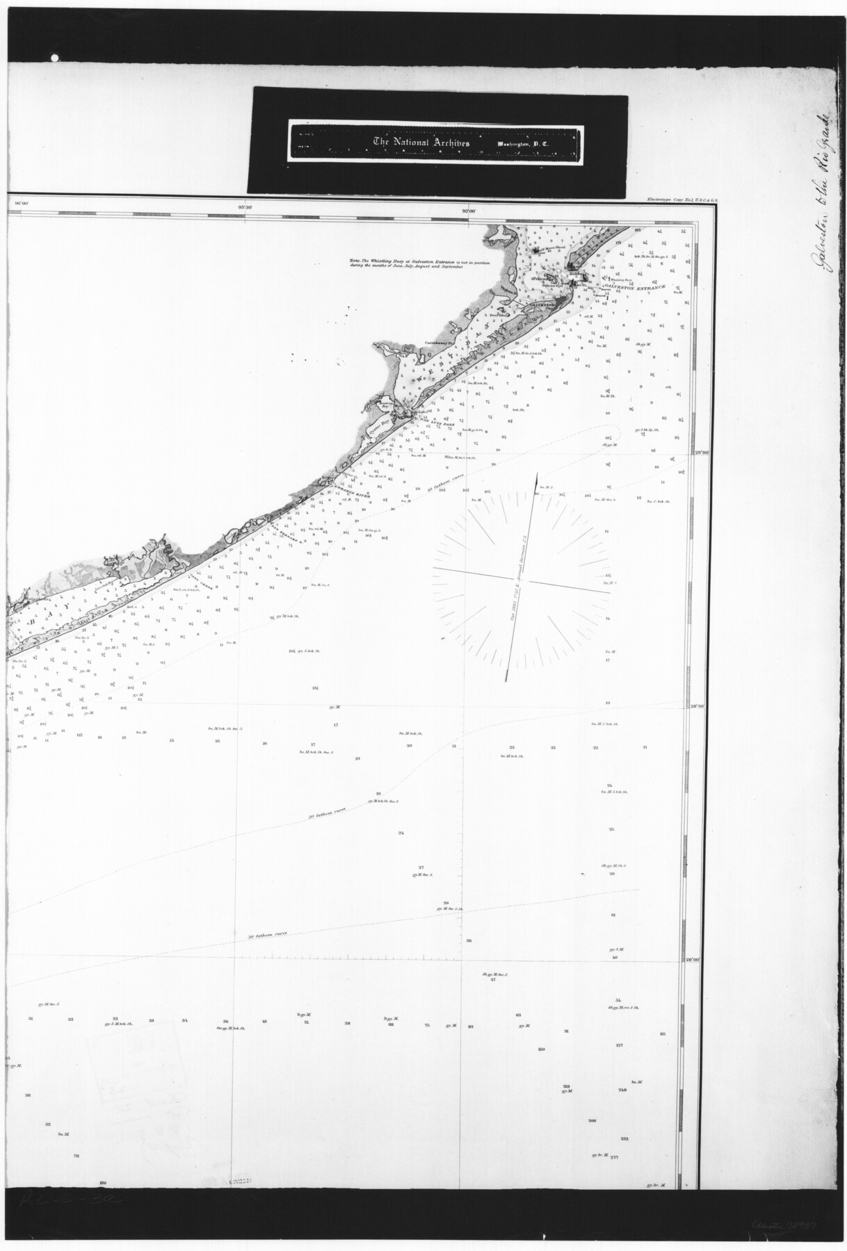
General Chart of the Coast No. XVI - Gulf Coast from Galveston to the Rio Grande
RL-2-3a
-
Map/Doc
72737
-
Collection
General Map Collection
-
Object Dates
1883 (Creation Date)
-
People and Organizations
U. S. Coast and Geodetic Survey (Publisher)
-
Subjects
Nautical Charts
-
Height x Width
26.8 x 18.1 inches
68.1 x 46.0 cm
-
Comments
B/W photostat copy from National Archives in multiple pieces.
Part of: General Map Collection
Harris County Working Sketch 122

Print $20.00
- Digital $50.00
Harris County Working Sketch 122
1986
Size 30.0 x 40.1 inches
Map/Doc 66014
Schleicher County Sketch File 35

Print $20.00
- Digital $50.00
Schleicher County Sketch File 35
1951
Size 13.8 x 19.4 inches
Map/Doc 12308
Gaines County Sketch File 21

Print $6.00
- Digital $50.00
Gaines County Sketch File 21
1990
Size 11.2 x 8.8 inches
Map/Doc 23341
Jack County Rolled Sketch 3

Print $20.00
- Digital $50.00
Jack County Rolled Sketch 3
1985
Size 30.3 x 27.5 inches
Map/Doc 6333
Map of Matagorda County

Print $20.00
- Digital $50.00
Map of Matagorda County
1839
Size 23.5 x 32.2 inches
Map/Doc 3844
Johnson County Working Sketch 22

Print $20.00
- Digital $50.00
Johnson County Working Sketch 22
1992
Size 14.6 x 18.1 inches
Map/Doc 66635
Flight Mission No. CRK-7P, Frame 25, Refugio County

Print $20.00
- Digital $50.00
Flight Mission No. CRK-7P, Frame 25, Refugio County
1956
Size 18.6 x 22.3 inches
Map/Doc 86945
Hale County Sketch File 26

Print $40.00
- Digital $50.00
Hale County Sketch File 26
1911
Size 20.7 x 54.4 inches
Map/Doc 10471

Hardin County Sketch File 62

Print $20.00
- Digital $50.00
Hardin County Sketch File 62
Size 19.9 x 26.2 inches
Map/Doc 11637
Flight Mission No. DAG-17K, Frame 137, Matagorda County

Print $20.00
- Digital $50.00
Flight Mission No. DAG-17K, Frame 137, Matagorda County
1952
Size 16.5 x 16.2 inches
Map/Doc 86354
Atascosa County Sketch File 34

Print $4.00
- Digital $50.00
Atascosa County Sketch File 34
Size 10.4 x 8.3 inches
Map/Doc 13827
You may also like
North Sulphur River, Sims Crossing Sheet

Print $20.00
- Digital $50.00
North Sulphur River, Sims Crossing Sheet
1924
Size 23.4 x 39.9 inches
Map/Doc 65167
Dallam County Rolled Sketch 7

Print $20.00
- Digital $50.00
Dallam County Rolled Sketch 7
Size 15.4 x 18.6 inches
Map/Doc 5685
Archer County Working Sketch 22

Print $20.00
- Digital $50.00
Archer County Working Sketch 22
1980
Size 36.4 x 38.0 inches
Map/Doc 67163
Whitehead Second Addition

Print $20.00
- Digital $50.00
Whitehead Second Addition
Size 11.0 x 18.6 inches
Map/Doc 92879
Lampasas County Rolled Sketch 2

Print $20.00
- Digital $50.00
Lampasas County Rolled Sketch 2
Size 21.0 x 39.2 inches
Map/Doc 6565
Edwards County Sketch File 48

Print $6.00
- Digital $50.00
Edwards County Sketch File 48
1955
Size 9.7 x 7.6 inches
Map/Doc 21797
Galveston Bay Entrance - Galveston and Texas City Harbors

Print $40.00
- Digital $50.00
Galveston Bay Entrance - Galveston and Texas City Harbors
1975
Size 37.4 x 53.5 inches
Map/Doc 69864

Tom Green County Sketch File 60

Print $20.00
- Digital $50.00
Tom Green County Sketch File 60
1888
Size 28.4 x 25.9 inches
Map/Doc 12444
Crockett County Rolled Sketch 91

Print $40.00
- Digital $50.00
Crockett County Rolled Sketch 91
1928
Size 26.0 x 70.5 inches
Map/Doc 8737
Houston Ship Channel, Alexander Island to Carpenter Bayou

Print $40.00
- Digital $50.00
Houston Ship Channel, Alexander Island to Carpenter Bayou
1992
Size 35.3 x 49.3 inches
Map/Doc 69917
[Galveston, Harrisburg & San Antonio through El Paso County]
![64001, [Galveston, Harrisburg & San Antonio through El Paso County], General Map Collection](https://historictexasmaps.com/wmedia_w700/maps/64001.tif.jpg)
Print $20.00
- Digital $50.00
[Galveston, Harrisburg & San Antonio through El Paso County]
1907
Size 13.6 x 33.7 inches
Map/Doc 64001