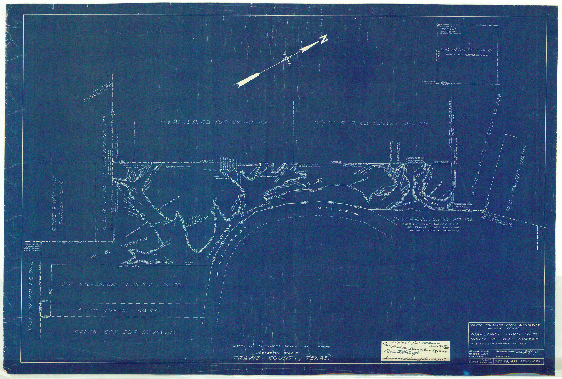
Travis County Rolled Sketch 15
Marshall Ford Dam right of way survey, W.B. Corwin survey no. 189
-
Map/Doc
10011
-
Collection
General Map Collection
-
Object Dates
1939/12/28 (Creation Date)
1940/7/2 (File Date)
-
People and Organizations
Orin E. Metcalfe (Surveyor/Engineer)
-
Counties
Travis
-
Subjects
Surveying Rolled Sketch
-
Height x Width
25.4 x 37.6 inches
64.5 x 95.5 cm
-
Medium
blueprint/diazo
-
Scale
1" = 180 varas
Part of: General Map Collection
Flight Mission No. CRC-2R, Frame 63, Chambers County

Print $20.00
- Digital $50.00
Flight Mission No. CRC-2R, Frame 63, Chambers County
1956
Size 18.8 x 22.4 inches
Map/Doc 84734
Flight Mission No. CLL-1N, Frame 12, Willacy County

Print $20.00
- Digital $50.00
Flight Mission No. CLL-1N, Frame 12, Willacy County
1954
Size 18.4 x 22.1 inches
Map/Doc 86999
Aransas County Sketch File 24

Print $36.00
- Digital $50.00
Aransas County Sketch File 24
1938
Size 10.9 x 8.3 inches
Map/Doc 13177
Galveston County Sketch File 30

Print $20.00
- Digital $50.00
Galveston County Sketch File 30
1915
Size 43.0 x 30.7 inches
Map/Doc 10455
Dickens County Working Sketch 14

Print $20.00
- Digital $50.00
Dickens County Working Sketch 14
1986
Size 25.5 x 30.7 inches
Map/Doc 62180
Kleberg County Rolled Sketch 5A

Print $20.00
- Digital $50.00
Kleberg County Rolled Sketch 5A
Size 31.0 x 25.1 inches
Map/Doc 6549
Runnels County Sketch File C

Print $4.00
Runnels County Sketch File C
Size 14.2 x 8.8 inches
Map/Doc 35457
Map of Wood County

Print $20.00
- Digital $50.00
Map of Wood County
1872
Size 15.6 x 16.8 inches
Map/Doc 4167
Collin County

Print $20.00
- Digital $50.00
Collin County
1975
Size 42.2 x 39.4 inches
Map/Doc 77242
Coast of Texas and its defences

Print $20.00
- Digital $50.00
Coast of Texas and its defences
Size 27.6 x 18.2 inches
Map/Doc 72685
Gillespie County Working Sketch 6

Print $20.00
- Digital $50.00
Gillespie County Working Sketch 6
1981
Size 22.5 x 21.6 inches
Map/Doc 63169
Culberson County Working Sketch 8

Print $20.00
- Digital $50.00
Culberson County Working Sketch 8
1914
Size 35.4 x 36.0 inches
Map/Doc 68460
You may also like
Jasper County

Print $40.00
- Digital $50.00
Jasper County
1898
Size 65.1 x 37.4 inches
Map/Doc 82048
Schleicher County Working Sketch 13

Print $20.00
- Digital $50.00
Schleicher County Working Sketch 13
1926
Size 19.6 x 16.2 inches
Map/Doc 63815
Anderson County Working Sketch 38

Print $20.00
- Digital $50.00
Anderson County Working Sketch 38
1985
Size 43.3 x 45.9 inches
Map/Doc 67038
Bee County Sketch File 7

Print $8.00
- Digital $50.00
Bee County Sketch File 7
1873
Size 10.1 x 8.0 inches
Map/Doc 14275
[Northeast 1/4 of County Map showing Durrell's Tie Line]
![91619, [Northeast 1/4 of County Map showing Durrell's Tie Line], Twichell Survey Records](https://historictexasmaps.com/wmedia_w700/maps/91619-1.tif.jpg)
Print $20.00
- Digital $50.00
[Northeast 1/4 of County Map showing Durrell's Tie Line]
Size 24.1 x 18.7 inches
Map/Doc 91619
The Compass Rose of Austin's Colony

Price $20.00
The Compass Rose of Austin's Colony
2016
Size 4.0 x 3.5 inches
Map/Doc 94443
The Republic County of Austin. February 5, 1840

Print $20.00
The Republic County of Austin. February 5, 1840
2020
Size 14.7 x 21.7 inches
Map/Doc 96084
Burnet County Rolled Sketch 7

Print $20.00
- Digital $50.00
Burnet County Rolled Sketch 7
1987
Size 18.4 x 24.0 inches
Map/Doc 5357
Wichita County Sketch File 17

Print $20.00
- Digital $50.00
Wichita County Sketch File 17
1889
Size 29.7 x 22.4 inches
Map/Doc 12680
Calhoun County Rolled Sketch 24

Print $40.00
- Digital $50.00
Calhoun County Rolled Sketch 24
1962
Size 26.0 x 58.3 inches
Map/Doc 5373

Bauer & Cockrell Lands Located in Martin County, Texas

Print $20.00
- Digital $50.00
Bauer & Cockrell Lands Located in Martin County, Texas
1908
Size 28.5 x 22.3 inches
Map/Doc 91365