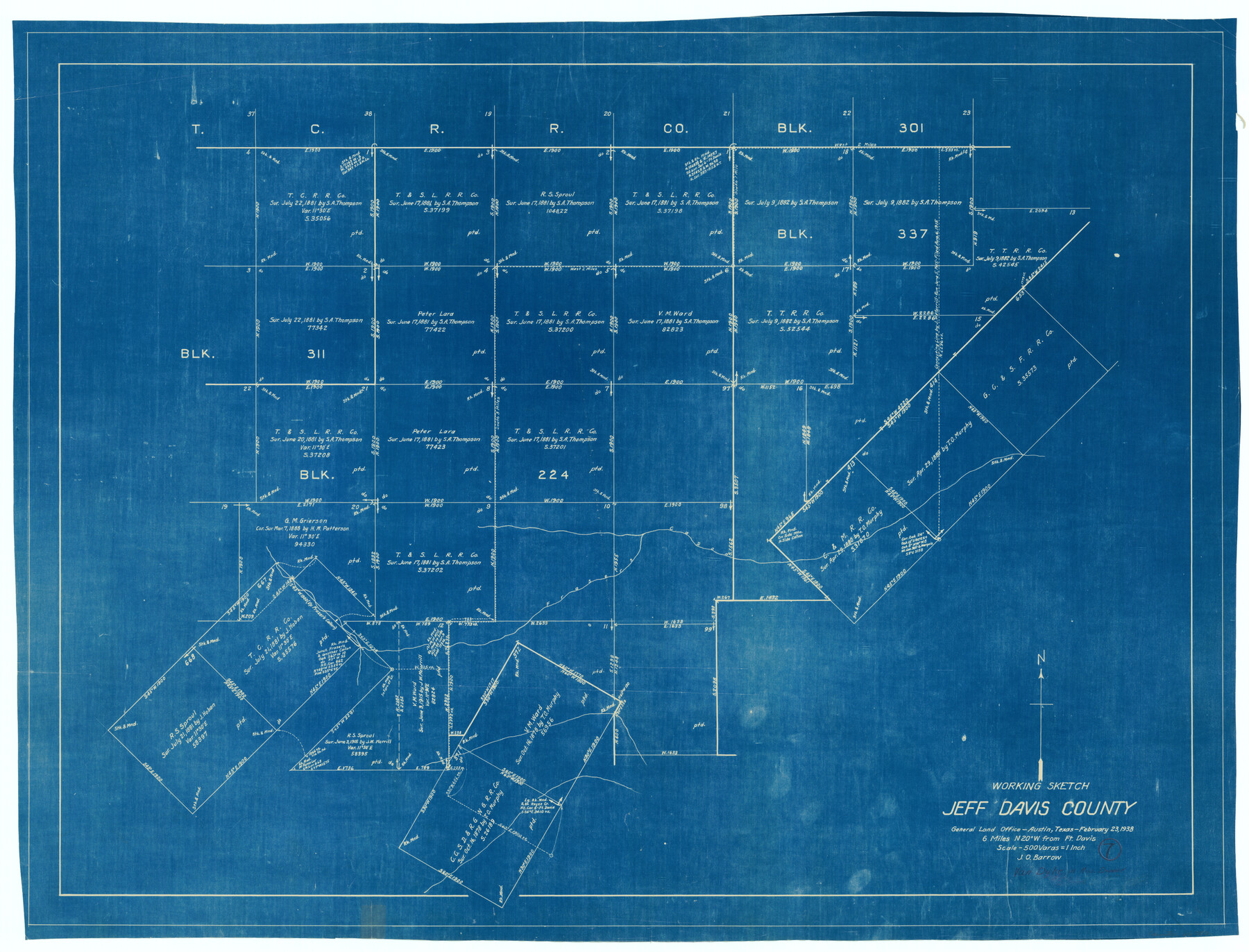
Jeff Davis County Working Sketch 7
-
Map/Doc
66502
-
Collection
General Map Collection
-
Object Dates
2/23/1938 (Creation Date)
-
People and Organizations
J.O. Barrow (Draftsman)
-
Counties
Jeff Davis
-
Subjects
Surveying Working Sketch
-
Height x Width
30.4 x 39.9 inches
77.2 x 101.4 cm
-
Scale
1" = 500 varas
Part of: General Map Collection
Clay County Sketch File 15

Print $4.00
- Digital $50.00
Clay County Sketch File 15
1873
Size 12.8 x 8.4 inches
Map/Doc 18419
McMullen County Working Sketch Graphic Index

Print $40.00
- Digital $50.00
McMullen County Working Sketch Graphic Index
1967
Size 49.4 x 34.6 inches
Map/Doc 76638
Jefferson County NRC Article 33.136 Sketch 8

Print $20.00
- Digital $50.00
Jefferson County NRC Article 33.136 Sketch 8
2007
Size 20.1 x 18.7 inches
Map/Doc 87503
Map of north end of Brazos Island

Print $20.00
- Digital $50.00
Map of north end of Brazos Island
Size 27.6 x 18.2 inches
Map/Doc 72908
Yoakum County Sketch File 10

Print $20.00
- Digital $50.00
Yoakum County Sketch File 10
1902
Size 33.7 x 18.8 inches
Map/Doc 12706
Right of Way and Track Map, the Missouri, Kansas and Texas Ry. of Texas - Henrietta Division

Print $20.00
- Digital $50.00
Right of Way and Track Map, the Missouri, Kansas and Texas Ry. of Texas - Henrietta Division
1918
Size 11.8 x 26.9 inches
Map/Doc 64748
Orange County Sketch File 31

Print $20.00
- Digital $50.00
Orange County Sketch File 31
1926
Size 17.9 x 20.0 inches
Map/Doc 12125
Jack County Working Sketch 17

Print $20.00
- Digital $50.00
Jack County Working Sketch 17
1982
Size 25.9 x 27.4 inches
Map/Doc 66443
Ward County Working Sketch 4

Print $20.00
- Digital $50.00
Ward County Working Sketch 4
1943
Size 17.0 x 16.7 inches
Map/Doc 72310
Brooks County Working Sketch 5

Print $20.00
- Digital $50.00
Brooks County Working Sketch 5
1906
Size 29.8 x 16.3 inches
Map/Doc 67789
Kleberg County Boundary File 4a

Print $40.00
- Digital $50.00
Kleberg County Boundary File 4a
Size 23.3 x 62.2 inches
Map/Doc 64997
[Map of Block 97, Borden and Scurry Co (Exhibit A); Map of Southeastern part of Young Territory; Map of part of of Borden, Fisher, Kent, Mitchell, Scurry and Garza Cos. Showing the north boundary line of the T&P 80 mile reservation]
![65690, [Map of Block 97, Borden and Scurry Co (Exhibit A); Map of Southeastern part of Young Territory; Map of part of of Borden, Fisher, Kent, Mitchell, Scurry and Garza Cos. Showing the north boundary line of the T&P 80 mile reservation], General Map Collection](https://historictexasmaps.com/wmedia_w700/maps/65690-1.tif.jpg)
Print $40.00
- Digital $50.00
[Map of Block 97, Borden and Scurry Co (Exhibit A); Map of Southeastern part of Young Territory; Map of part of of Borden, Fisher, Kent, Mitchell, Scurry and Garza Cos. Showing the north boundary line of the T&P 80 mile reservation]
Size 58.7 x 42.4 inches
Map/Doc 65690
You may also like
Matagorda County Rolled Sketch 18

Print $20.00
- Digital $50.00
Matagorda County Rolled Sketch 18
1838
Size 35.7 x 30.8 inches
Map/Doc 6685
Map of Van Zandt County

Print $20.00
- Digital $50.00
Map of Van Zandt County
1853
Size 19.4 x 20.6 inches
Map/Doc 16957
Aransas County Sketch File 1

Print $4.00
- Digital $50.00
Aransas County Sketch File 1
Size 7.5 x 5.3 inches
Map/Doc 13098
Map of Texas compiled from surveys at the Land Office of Texas

Print $20.00
- Digital $50.00
Map of Texas compiled from surveys at the Land Office of Texas
1851
Size 26.7 x 19.1 inches
Map/Doc 96431
Terrell County Working Sketch 48

Print $40.00
- Digital $50.00
Terrell County Working Sketch 48
1958
Size 59.3 x 42.2 inches
Map/Doc 62141
Kleberg County Boundary File 2c

Print $40.00
- Digital $50.00
Kleberg County Boundary File 2c
Size 8.8 x 49.6 inches
Map/Doc 64979
Zavala County Rolled Sketch 23

Print $20.00
- Digital $50.00
Zavala County Rolled Sketch 23
1943
Size 17.0 x 25.6 inches
Map/Doc 8326
Morris County Rolled Sketch 2A

Print $20.00
- Digital $50.00
Morris County Rolled Sketch 2A
Size 24.2 x 19.0 inches
Map/Doc 10276
Texas Boundary Line

Print $20.00
- Digital $50.00
Texas Boundary Line
Size 21.6 x 11.9 inches
Map/Doc 92078
[East Half of Hutchinson County South of the Canadian River]
![91180, [East Half of Hutchinson County South of the Canadian River], Twichell Survey Records](https://historictexasmaps.com/wmedia_w700/maps/91180-1.tif.jpg)
Print $20.00
- Digital $50.00
[East Half of Hutchinson County South of the Canadian River]
Size 18.1 x 15.7 inches
Map/Doc 91180
Kimble County Working Sketch 33

Print $20.00
- Digital $50.00
Kimble County Working Sketch 33
1945
Size 29.8 x 29.2 inches
Map/Doc 70101
Red River County Sketch File 15

Print $4.00
- Digital $50.00
Red River County Sketch File 15
1863
Size 12.1 x 7.2 inches
Map/Doc 35137