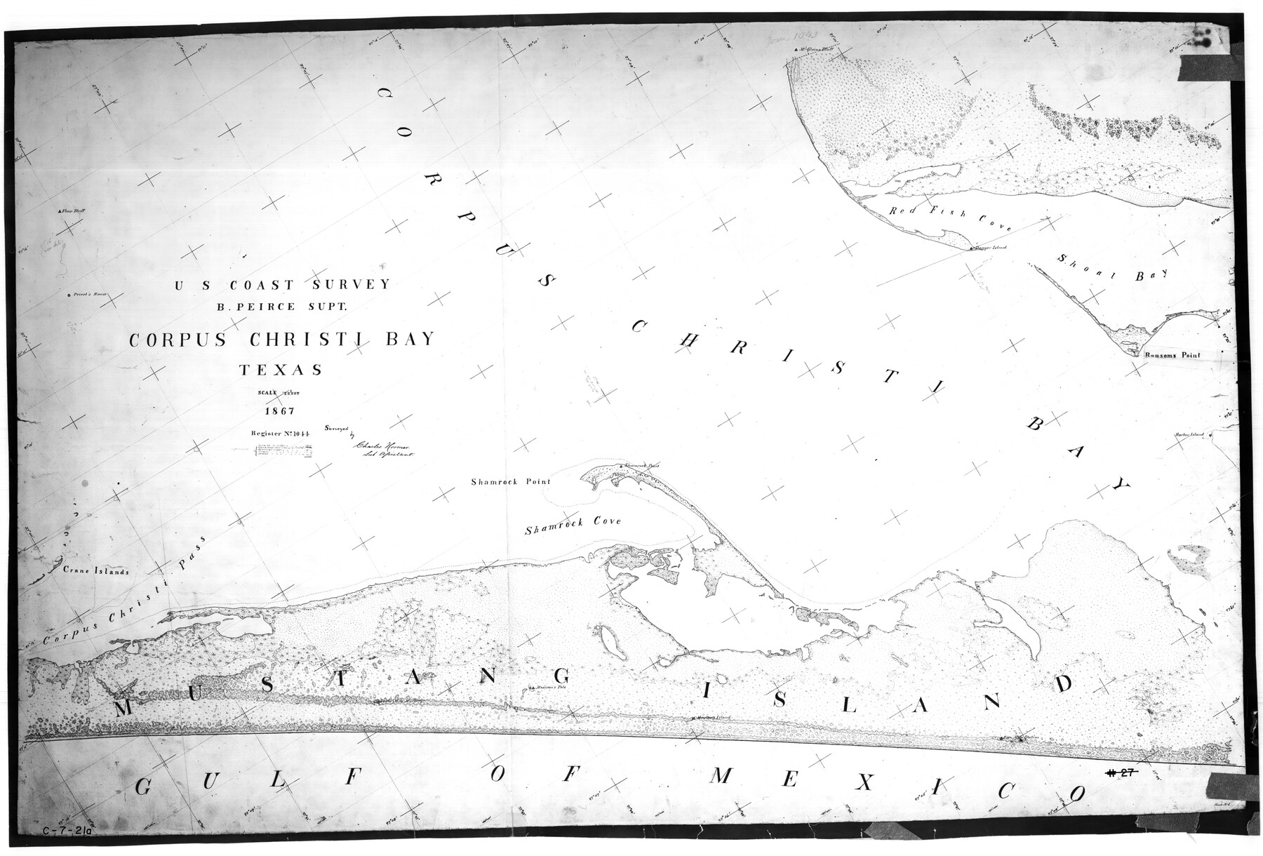
Corpus Christi Bay, Texas
C-7-21a
- 
                          Map/Doc
73467
 - 
                            Collection
General Map Collection
 - 
                            Object Dates
1867 (Creation Date)
 - 
                            Counties
Nueces San Patricio
 - 
                            Subjects
Nautical Charts
 - 
                            Height x Width
33.0 x 48.7 inches
83.8 x 123.7 cm
 
Part of: General Map Collection
            Flight Mission No. DQN-2K, Frame 22, Calhoun County


                                            Print $20.00                    
                                             -                         Digital $50.00                                    
                Flight Mission No. DQN-2K, Frame 22, Calhoun County
1953
Size 16.9 x 18.9 inches
                                Map/Doc 84229
            
            Crockett County Working Sketch 92


                                            Print $20.00                    
                                             -                         Digital $50.00                                    
                Crockett County Working Sketch 92
1978
Size 39.5 x 41.2 inches
                                Map/Doc 68425
            
            [Surveys near Keechi Creek and the Trinity River]


                                            Print $2.00                    
                                             -                         Digital $50.00                                    
                [Surveys near Keechi Creek and the Trinity River]
1841
Size 8.6 x 8.2 inches
                                Map/Doc 47
            
            Floyd County Rolled Sketch 10


                                            Print $20.00                    
                                             -                         Digital $50.00                                    
                Floyd County Rolled Sketch 10
1953
Size 37.8 x 25.0 inches
                                Map/Doc 5883
            
            Current Miscellaneous File 71


                                            Print $8.00                    
                                             -                         Digital $50.00                                    
                Current Miscellaneous File 71
Size 11.2 x 8.8 inches
                                Map/Doc 74155
            
            Newton County Working Sketch 34


                                            Print $20.00                    
                                             -                         Digital $50.00                                    
                Newton County Working Sketch 34
1959
Size 27.0 x 32.6 inches
                                Map/Doc 71280
            
            Upshur County Sketch File 14


                                            Print $10.00                    
                                             -                         Digital $50.00                                    
                Upshur County Sketch File 14
1936
Size 11.4 x 8.8 inches
                                Map/Doc 38757
            
            Montgomery County Working Sketch 1


                                            Print $20.00                    
                                             -                         Digital $50.00                                    
                Montgomery County Working Sketch 1
1912
Size 20.8 x 17.1 inches
                                Map/Doc 71107
            
            Map of subdivision of submerged land in the Gulf of Mexico fronting on Matagorda Island and Peninsula


                                            Print $40.00                    
                                             -                         Digital $50.00                                    
                Map of subdivision of submerged land in the Gulf of Mexico fronting on Matagorda Island and Peninsula
1940
Size 28.2 x 61.3 inches
                                Map/Doc 2929
            
            Liberty County Working Sketch 60


                                            Print $20.00                    
                                             -                         Digital $50.00                                    
                Liberty County Working Sketch 60
1969
Size 41.3 x 34.1 inches
                                Map/Doc 70520
            
            Proceedings of the International Boundary Commission, United States and Mexico, American Section, Elimination of Fifty-Seven Old Bancos Specifically Described in the Treaty of 1905


            Proceedings of the International Boundary Commission, United States and Mexico, American Section, Elimination of Fifty-Seven Old Bancos Specifically Described in the Treaty of 1905
Size 12.2 x 9.3 inches
                                Map/Doc 83124
            You may also like
            Culberson County Rolled Sketch 57


                                            Print $40.00                    
                                             -                         Digital $50.00                                    
                Culberson County Rolled Sketch 57
1967
Size 76.9 x 44.2 inches
                                Map/Doc 8758
            
            Mason County Working Sketch Graphic Index


                                            Print $20.00                    
                                             -                         Digital $50.00                                    
                Mason County Working Sketch Graphic Index
1980
Size 46.4 x 35.7 inches
                                Map/Doc 76632
            
            [K. N. Hapgood's Pasture and surrounding surveys]


                                            Print $2.00                    
                                             -                         Digital $50.00                                    
                [K. N. Hapgood's Pasture and surrounding surveys]
1923
Size 8.7 x 11.5 inches
                                Map/Doc 90432
            
            Harris County Sketch File 32


                                            Print $14.00                    
                                             -                         Digital $50.00                                    
                Harris County Sketch File 32
1900
Size 6.7 x 8.8 inches
                                Map/Doc 25429
            
            [Atlas E, Table of Contents]


                                            Print $3.00                    
                                             -                         Digital $50.00                                    
                [Atlas E, Table of Contents]
Size 17.8 x 11.0 inches
                                Map/Doc 78357
            
            The Republic County of Harrison. January 8, 1844


                                            Print $20.00                    
                                    
                The Republic County of Harrison. January 8, 1844
2020
Size 18.6 x 21.7 inches
                                Map/Doc 96175
            
            Part of Garza, Crosby, Lynn, and Lubbock Counties


                                            Print $20.00                    
                                             -                         Digital $50.00                                    
                Part of Garza, Crosby, Lynn, and Lubbock Counties
1912
Size 25.3 x 20.0 inches
                                Map/Doc 91312
            
            Bell County Sketch File 25a


                                            Print $4.00                    
                                             -                         Digital $50.00                                    
                Bell County Sketch File 25a
1880
Size 8.9 x 10.9 inches
                                Map/Doc 14424
            
            Flight Mission No. CUG-3P, Frame 31, Kleberg County


                                            Print $20.00                    
                                             -                         Digital $50.00                                    
                Flight Mission No. CUG-3P, Frame 31, Kleberg County
1956
Size 18.5 x 22.4 inches
                                Map/Doc 86236
            
            Kimble County Working Sketch Graphic Index, Sheet 1 (Sketches 1 to 46)


                                            Print $40.00                    
                                             -                         Digital $50.00                                    
                Kimble County Working Sketch Graphic Index, Sheet 1 (Sketches 1 to 46)
1930
Size 41.2 x 49.6 inches
                                Map/Doc 76606
            
            [Surveys between Big Keechi Creek and the Trinity River]


                                            Print $2.00                    
                                             -                         Digital $50.00                                    
                [Surveys between Big Keechi Creek and the Trinity River]
Size 10.1 x 7.3 inches
                                Map/Doc 69753