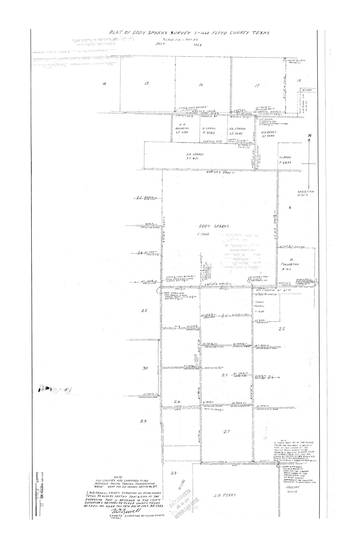
Floyd County Rolled Sketch 10
Plat of Eddy Sparks survey 1-1662, Floyd County, Texas
-
Map/Doc
5883
-
Collection
General Map Collection
-
Object Dates
1953/7/18 (Creation Date)
1970/1/16 (File Date)
-
People and Organizations
W.D. Newell (Surveyor/Engineer)
-
Counties
Floyd
-
Subjects
Surveying Rolled Sketch
-
Height x Width
37.8 x 25.0 inches
96.0 x 63.5 cm
-
Scale
1" = 500 varas
Part of: General Map Collection
Blanco County Sketch File 32

Print $4.00
- Digital $50.00
Blanco County Sketch File 32
1888
Size 8.5 x 11.1 inches
Map/Doc 14633
Ochiltree County

Print $20.00
- Digital $50.00
Ochiltree County
1908
Size 42.6 x 37.5 inches
Map/Doc 66958
Flight Mission No. DCL-7C, Frame 22, Kenedy County

Print $20.00
- Digital $50.00
Flight Mission No. DCL-7C, Frame 22, Kenedy County
1943
Size 15.4 x 15.2 inches
Map/Doc 86014
Eastland County Working Sketch 23

Print $40.00
- Digital $50.00
Eastland County Working Sketch 23
1920
Size 53.5 x 42.5 inches
Map/Doc 68804
Concho County Working Sketch 10

Print $20.00
- Digital $50.00
Concho County Working Sketch 10
1951
Size 21.2 x 15.6 inches
Map/Doc 68192
[University Lands in El Paso County]
![2426, [University Lands in El Paso County], General Map Collection](https://historictexasmaps.com/wmedia_w700/maps/2426.tif.jpg)
Print $20.00
- Digital $50.00
[University Lands in El Paso County]
1886
Size 29.0 x 43.4 inches
Map/Doc 2426
Johnson County Boundary File 51c

Print $18.00
- Digital $50.00
Johnson County Boundary File 51c
Size 8.2 x 5.2 inches
Map/Doc 55622
La Florida / Peruviae Avriferæ Regionis Typus / Guastecan

Print $20.00
- Digital $50.00
La Florida / Peruviae Avriferæ Regionis Typus / Guastecan
1584
Size 16.8 x 20.9 inches
Map/Doc 94100
Brewster County Working Sketch 74

Print $20.00
- Digital $50.00
Brewster County Working Sketch 74
1966
Size 24.8 x 32.0 inches
Map/Doc 67674
Hunt County Working Sketch 6

Print $20.00
- Digital $50.00
Hunt County Working Sketch 6
1942
Size 31.0 x 40.3 inches
Map/Doc 66353
Jefferson County NRC Article 33.136 Sketch 2

Print $20.00
- Digital $50.00
Jefferson County NRC Article 33.136 Sketch 2
2002
Size 24.3 x 35.9 inches
Map/Doc 77048
Panola County Working Sketch 24

Print $20.00
- Digital $50.00
Panola County Working Sketch 24
1957
Map/Doc 71433
You may also like
Presidio County Working Sketch 83

Print $20.00
- Digital $50.00
Presidio County Working Sketch 83
1969
Size 21.5 x 24.8 inches
Map/Doc 71760
Grayson County Working Sketch 11

Print $20.00
- Digital $50.00
Grayson County Working Sketch 11
1951
Size 27.9 x 24.3 inches
Map/Doc 63250
Duval County Sketch File 34

Print $20.00
- Digital $50.00
Duval County Sketch File 34
Size 28.4 x 36.9 inches
Map/Doc 11391
Garza County Working Sketch 10

Print $20.00
- Digital $50.00
Garza County Working Sketch 10
1953
Size 11.1 x 18.7 inches
Map/Doc 63157
Pecos County Working Sketch 52

Print $20.00
- Digital $50.00
Pecos County Working Sketch 52
1948
Size 46.8 x 32.5 inches
Map/Doc 71524
Reeves County Working Sketch 46

Print $40.00
- Digital $50.00
Reeves County Working Sketch 46
1974
Size 52.4 x 37.2 inches
Map/Doc 63489
Coleman County Working Sketch 1

Print $20.00
- Digital $50.00
Coleman County Working Sketch 1
1900
Size 11.1 x 21.2 inches
Map/Doc 68067
A Camera Journey through the Lower Valley of the Rio Grande - the Garden of Golden Grapefruit

A Camera Journey through the Lower Valley of the Rio Grande - the Garden of Golden Grapefruit
1929
Map/Doc 96744
Reagan County Rolled Sketch 13

Print $20.00
- Digital $50.00
Reagan County Rolled Sketch 13
Size 25.5 x 38.0 inches
Map/Doc 7441
Tyler County Sketch File 4

Print $4.00
- Digital $50.00
Tyler County Sketch File 4
1857
Size 13.9 x 8.4 inches
Map/Doc 38628
![94191, California [Verso], General Map Collection](https://historictexasmaps.com/wmedia_w700/maps/94191.tif.jpg)
Andrews County Rolled Sketch 35

Print $20.00
- Digital $50.00
Andrews County Rolled Sketch 35
Size 21.5 x 16.1 inches
Map/Doc 77177