Victoria County Sketch File 10
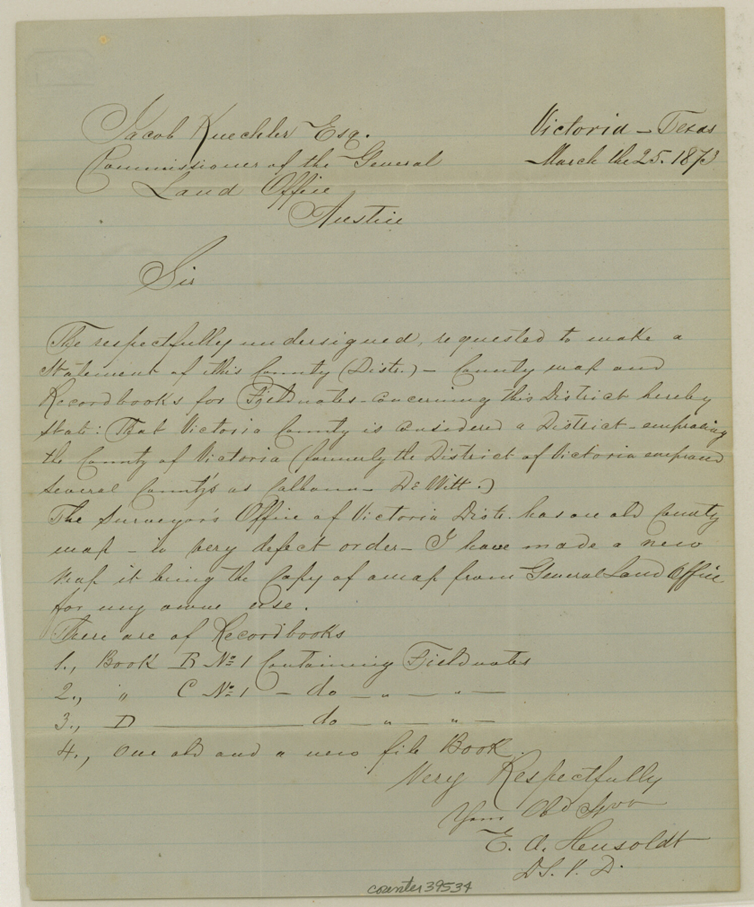
[County Surveyor report on County Records]
-
Map/Doc
39534
-
Collection
General Map Collection
-
Object Dates
3/25/1873 (Creation Date)
12/6/1984 (File Date)
-
People and Organizations
E.A. Hensoldt (Surveyor/Engineer)
-
Counties
Victoria
-
Subjects
Surveying Sketch File
-
Height x Width
10.1 x 8.4 inches
25.7 x 21.3 cm
-
Medium
paper, manuscript
Part of: General Map Collection
Bell County Sketch File 9

Print $4.00
- Digital $50.00
Bell County Sketch File 9
Size 10.0 x 8.2 inches
Map/Doc 14379
Angelina County Sketch File 2

Print $2.00
- Digital $50.00
Angelina County Sketch File 2
Size 8.6 x 6.0 inches
Map/Doc 12921
Brewster County Rolled Sketch OS

Print $20.00
- Digital $50.00
Brewster County Rolled Sketch OS
Size 17.6 x 21.7 inches
Map/Doc 5323
Presidio County Rolled Sketch 138

Print $20.00
- Digital $50.00
Presidio County Rolled Sketch 138
2000
Size 36.7 x 25.1 inches
Map/Doc 7405
Burnet County Working Sketch 27

Print $20.00
- Digital $50.00
Burnet County Working Sketch 27
2025
Size 24.5 x 36.0 inches
Map/Doc 97419
Hartley County Sketch File 16

Print $4.00
- Digital $50.00
Hartley County Sketch File 16
Size 11.1 x 7.1 inches
Map/Doc 26113
Rio Grande, Willamar Sheet

Print $20.00
- Digital $50.00
Rio Grande, Willamar Sheet
1937
Size 36.9 x 37.2 inches
Map/Doc 65111
Controlled Mosaic by Jack Amman Photogrammetric Engineers, Inc - Sheet 41

Print $20.00
- Digital $50.00
Controlled Mosaic by Jack Amman Photogrammetric Engineers, Inc - Sheet 41
1954
Size 20.0 x 24.0 inches
Map/Doc 83496
King County Boundary File 2

Print $54.00
- Digital $50.00
King County Boundary File 2
Size 8.8 x 7.7 inches
Map/Doc 64887
Tarrant County Sketch File 1

Print $4.00
- Digital $50.00
Tarrant County Sketch File 1
1851
Size 10.2 x 7.9 inches
Map/Doc 37672
Flight Mission No. BRA-7M, Frame 17, Jefferson County

Print $20.00
- Digital $50.00
Flight Mission No. BRA-7M, Frame 17, Jefferson County
1953
Size 18.6 x 22.4 inches
Map/Doc 85468
Flight Mission No. DQN-5K, Frame 38, Calhoun County

Print $20.00
- Digital $50.00
Flight Mission No. DQN-5K, Frame 38, Calhoun County
1953
Size 19.1 x 22.7 inches
Map/Doc 84386
You may also like
Edwards County Sketch File 26

Print $4.00
- Digital $50.00
Edwards County Sketch File 26
1910
Size 11.5 x 9.2 inches
Map/Doc 21753
[F. W. & D. C. Ry. Co. Alignment and Right of Way Map, Clay County]
![64723, [F. W. & D. C. Ry. Co. Alignment and Right of Way Map, Clay County], General Map Collection](https://historictexasmaps.com/wmedia_w700/maps/64723-1.tif.jpg)
Print $20.00
- Digital $50.00
[F. W. & D. C. Ry. Co. Alignment and Right of Way Map, Clay County]
1927
Size 18.6 x 11.8 inches
Map/Doc 64723
Western portion of the Ward Ranch, Cottle, Foard & Hardeman Counties, Swearingen, Texas sold to Luther T. Clark

Print $20.00
- Digital $50.00
Western portion of the Ward Ranch, Cottle, Foard & Hardeman Counties, Swearingen, Texas sold to Luther T. Clark
1916
Size 30.4 x 30.7 inches
Map/Doc 4460
Baylor County Sketch File 23a

Print $10.00
- Digital $50.00
Baylor County Sketch File 23a
1927
Size 14.3 x 8.9 inches
Map/Doc 14204
Van Zandt County Sketch File 10

Print $4.00
- Digital $50.00
Van Zandt County Sketch File 10
1858
Size 6.2 x 8.0 inches
Map/Doc 39395
Red River County Sketch File 1a

Print $4.00
- Digital $50.00
Red River County Sketch File 1a
1854
Size 12.7 x 8.0 inches
Map/Doc 35093
Hutchinson County Working Sketch 36

Print $20.00
- Digital $50.00
Hutchinson County Working Sketch 36
1978
Size 27.2 x 22.4 inches
Map/Doc 66396
Stonewall County Boundary File 1

Print $34.00
- Digital $50.00
Stonewall County Boundary File 1
Size 9.0 x 8.4 inches
Map/Doc 58938
J No. 5 - Reconnaissance of San Clemente Harbor, California / Reconnaissance of Prisoner's Harbor, California / Reconnaissance of Cuyler's Harbor, Island of San Miguel, California

Print $20.00
- Digital $50.00
J No. 5 - Reconnaissance of San Clemente Harbor, California / Reconnaissance of Prisoner's Harbor, California / Reconnaissance of Cuyler's Harbor, Island of San Miguel, California
1852
Size 19.2 x 16.5 inches
Map/Doc 97234

Zavala County Rolled Sketch 14

Print $20.00
- Digital $50.00
Zavala County Rolled Sketch 14
1887
Size 28.1 x 40.8 inches
Map/Doc 10175
Map of the Reconnaissance in Texas by Lieuts Blake & Meade of the Corps of Topl. Engrs.

Print $20.00
- Digital $50.00
Map of the Reconnaissance in Texas by Lieuts Blake & Meade of the Corps of Topl. Engrs.
1845
Size 27.7 x 18.5 inches
Map/Doc 72892