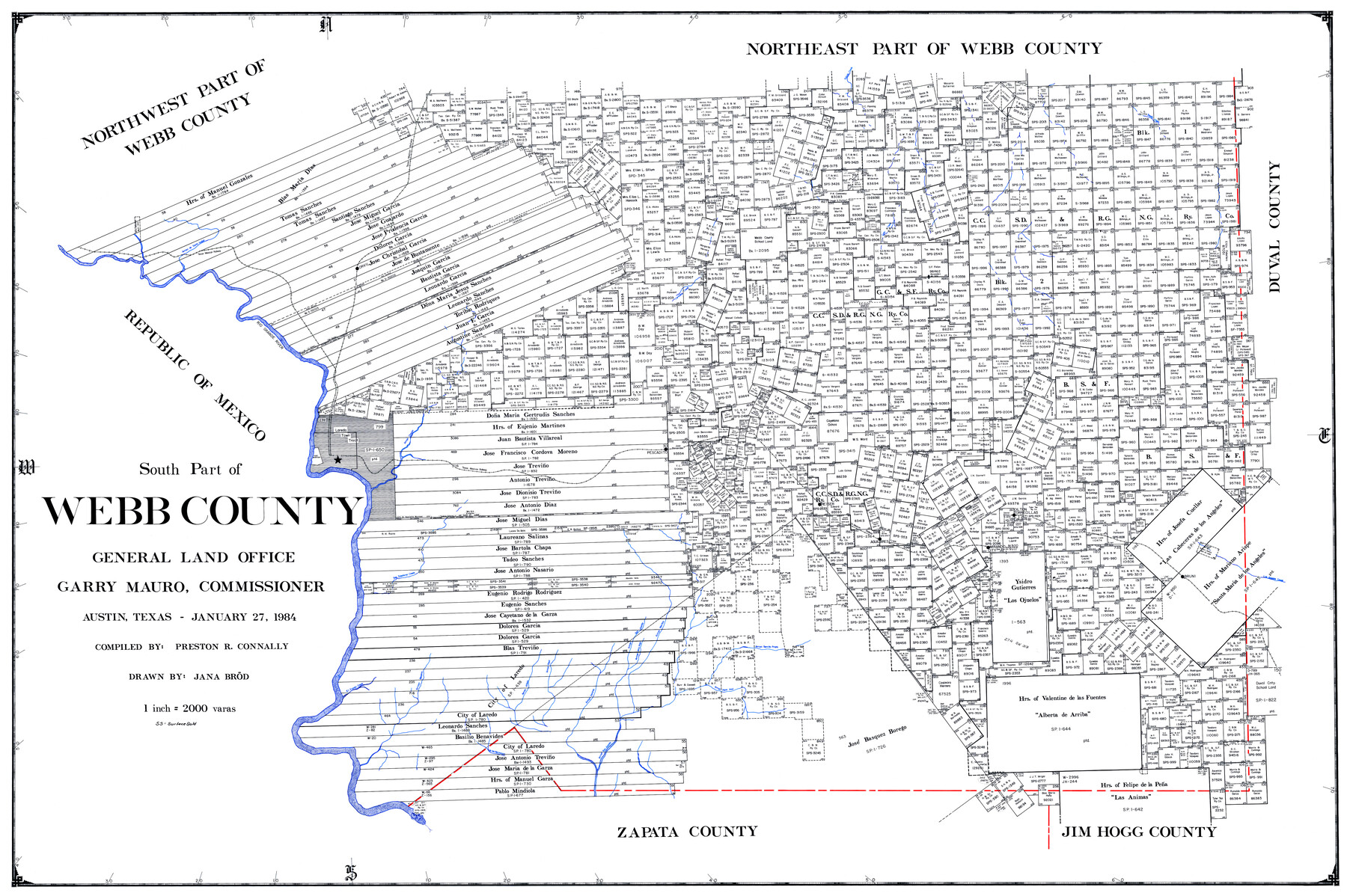
South Part of Webb County
-
Map/Doc
73320
-
Collection
General Map Collection
-
Object Dates
1984/1/27 (Creation Date)
-
People and Organizations
Texas General Land Office (Publisher)
Preston R. Connally (Compiler)
Garry Mauro (GLO Commissioner)
Jana Brod (Draftsman)
-
Counties
Webb
-
Subjects
County
-
Height x Width
43.5 x 63.9 inches
110.5 x 162.3 cm
-
Comments
Leroy lettered.
-
Features
Arroyo San Juanita
Arroyo Serrito Prieto
Laguna Tordilla
Arroyo Chacon
Fort McIntosh
Rio Grande
Deramdero del Gato
Arroyo de Santa Isabel
[Arroyo] de las Hermanas
Laredo
Arroyo Aqua Azul
Arroyo Delores
Arroyo Sauz
Arroyo Jobers
Arroyo Becerro
El Espejo Creek
Salado Creek
Arroyo de la Hoya
Arroyo Meritas
Los Angeles Creek
Bruni
San Ildeforso Creek
Aguilares
Mirando City
Oilton Torrecillas
Reiser
Pescadito
Carricitos Creek
Orvil
Cato Creek
TMRR
Toteña Creek
Part of: General Map Collection
Padre Island National Seashore, Texas - Dependent Resurvey

Print $4.00
- Digital $50.00
Padre Island National Seashore, Texas - Dependent Resurvey
2001
Size 18.3 x 24.4 inches
Map/Doc 60545
Flight Mission No. DQO-8K, Frame 64, Galveston County

Print $20.00
- Digital $50.00
Flight Mission No. DQO-8K, Frame 64, Galveston County
1952
Size 18.6 x 22.4 inches
Map/Doc 85168
Castro County Sketch File 16

Print $4.00
- Digital $50.00
Castro County Sketch File 16
1891
Size 11.0 x 8.8 inches
Map/Doc 17513
Duval County Sketch File 57

Print $14.00
- Digital $50.00
Duval County Sketch File 57
1939
Size 14.2 x 8.9 inches
Map/Doc 21418
Flight Mission No. DIX-8P, Frame 64, Aransas County

Print $20.00
- Digital $50.00
Flight Mission No. DIX-8P, Frame 64, Aransas County
1956
Size 18.7 x 22.4 inches
Map/Doc 83895
Webb County Working Sketch 68

Print $40.00
- Digital $50.00
Webb County Working Sketch 68
1967
Size 31.6 x 50.7 inches
Map/Doc 72435

Comal County Sketch File 9 1/2

Print $6.00
- Digital $50.00
Comal County Sketch File 9 1/2
Size 12.9 x 8.4 inches
Map/Doc 19018
Harris County Rolled Sketch 96B

Print $20.00
- Digital $50.00
Harris County Rolled Sketch 96B
Size 15.8 x 15.6 inches
Map/Doc 10681
Concho County Rolled Sketch 23

Print $20.00
- Digital $50.00
Concho County Rolled Sketch 23
1971
Size 22.8 x 22.4 inches
Map/Doc 78463
Newton County Sketch File 45

Print $12.00
- Digital $50.00
Newton County Sketch File 45
1957
Size 14.1 x 8.7 inches
Map/Doc 32445
Vicinity of San Luis Pass, Galveston Island, Texas

Print $40.00
- Digital $50.00
Vicinity of San Luis Pass, Galveston Island, Texas
1933
Size 37.1 x 57.8 inches
Map/Doc 69943
You may also like
Travis County Working Sketch 42

Print $20.00
- Digital $50.00
Travis County Working Sketch 42
1974
Size 32.5 x 35.2 inches
Map/Doc 69426
Panola County Working Sketch 22

Print $20.00
- Digital $50.00
Panola County Working Sketch 22
1951
Map/Doc 71431
Webb County Sketch File 3

Print $8.00
- Digital $50.00
Webb County Sketch File 3
Size 9.8 x 9.3 inches
Map/Doc 39713
Flight Mission No. DCL-7C, Frame 133, Kenedy County

Print $20.00
- Digital $50.00
Flight Mission No. DCL-7C, Frame 133, Kenedy County
1943
Size 15.4 x 15.2 inches
Map/Doc 86090
Sherman County Sketch File B

Print $6.00
- Digital $50.00
Sherman County Sketch File B
1919
Size 14.4 x 8.8 inches
Map/Doc 36691

[Public School Land Blocks B1 and B7]
![91974, [Public School Land Blocks B1 and B7], Twichell Survey Records](https://historictexasmaps.com/wmedia_w700/maps/91974-1.tif.jpg)
Print $20.00
- Digital $50.00
[Public School Land Blocks B1 and B7]
Size 22.9 x 14.8 inches
Map/Doc 91974
Flight Mission No. DIX-3P, Frame 138, Aransas County

Print $20.00
- Digital $50.00
Flight Mission No. DIX-3P, Frame 138, Aransas County
1956
Size 17.7 x 18.6 inches
Map/Doc 83768
Franklin County Sketch File 17

Print $16.00
- Digital $50.00
Franklin County Sketch File 17
1951
Size 11.3 x 8.8 inches
Map/Doc 23026
Wilbarger County Working Sketch 20

Print $20.00
- Digital $50.00
Wilbarger County Working Sketch 20
1976
Size 27.4 x 43.4 inches
Map/Doc 72558
Kleberg County Rolled Sketch 10-31

Print $20.00
- Digital $50.00
Kleberg County Rolled Sketch 10-31
1952
Size 37.9 x 40.3 inches
Map/Doc 9398
Kimble County Rolled Sketch 15

Print $59.00
- Digital $50.00
Kimble County Rolled Sketch 15
1886
Size 28.3 x 42.1 inches
Map/Doc 6508