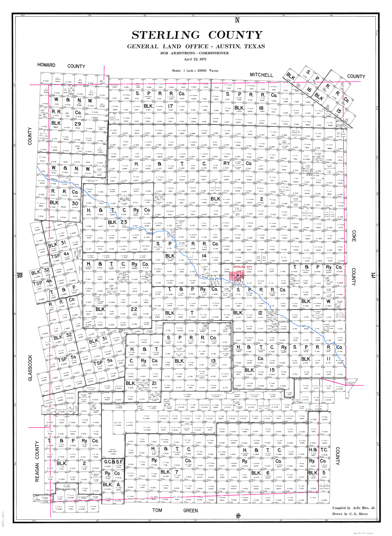
Sterling County
-
Map/Doc
73294
-
Collection
General Map Collection
-
Object Dates
1971/4/22 (Creation Date)
-
People and Organizations
Texas General Land Office (Publisher)
Arlie R. Bice Jr. (Compiler)
Bob Armstrong (GLO Commissioner)
C.L. Slover (Draftsman)
-
Counties
Sterling
-
Subjects
County
-
Height x Width
44.7 x 33.4 inches
113.5 x 84.8 cm
-
Comments
Leroy lettered.
-
Features
North Concho River
Sterling City
Part of: General Map Collection
Travis County Rolled Sketch 55

Print $40.00
- Digital $50.00
Travis County Rolled Sketch 55
Size 43.1 x 50.5 inches
Map/Doc 10020
Colorado County Working Sketch 23

Print $20.00
- Digital $50.00
Colorado County Working Sketch 23
1967
Size 38.0 x 32.9 inches
Map/Doc 68123
Parker County Working Sketch 26

Print $20.00
- Digital $50.00
Parker County Working Sketch 26
2008
Map/Doc 88856
Burnet County Sketch File 27a

Print $10.00
- Digital $50.00
Burnet County Sketch File 27a
1876
Size 8.7 x 8.2 inches
Map/Doc 16732
Galveston County Aerial Photograph Index Sheet 5

Print $20.00
- Digital $50.00
Galveston County Aerial Photograph Index Sheet 5
1953
Size 23.1 x 18.8 inches
Map/Doc 83696
Hardin County Sketch File 5

Print $5.00
- Digital $50.00
Hardin County Sketch File 5
1856
Size 9.0 x 6.6 inches
Map/Doc 25092
Hardeman County Sketch File A2

Print $20.00
- Digital $50.00
Hardeman County Sketch File A2
Size 28.5 x 17.3 inches
Map/Doc 11631
Crosby County Sketch File 5

Print $10.00
- Digital $50.00
Crosby County Sketch File 5
1887
Size 9.2 x 7.8 inches
Map/Doc 20002
Refugio County Sketch File 13

Print $5.00
- Digital $50.00
Refugio County Sketch File 13
Size 8.2 x 10.3 inches
Map/Doc 35265
Washington County Sketch File 4

Print $4.00
- Digital $50.00
Washington County Sketch File 4
1863
Size 12.8 x 7.8 inches
Map/Doc 39650
Eastland County Working Sketch 21

Print $20.00
- Digital $50.00
Eastland County Working Sketch 21
1920
Size 15.4 x 22.7 inches
Map/Doc 68802
Texas, Matagorda Bay, Port O'Connor to Gallinipper Point

Print $40.00
- Digital $50.00
Texas, Matagorda Bay, Port O'Connor to Gallinipper Point
1933
Size 31.1 x 48.6 inches
Map/Doc 69985
You may also like
Harrison County Working Sketch 29

Print $20.00
- Digital $50.00
Harrison County Working Sketch 29
Size 33.7 x 37.0 inches
Map/Doc 66049
Presidio County Rolled Sketch 90

Print $20.00
- Digital $50.00
Presidio County Rolled Sketch 90
1947
Size 20.5 x 24.4 inches
Map/Doc 7375
Flight Mission No. DCL-5C, Frame 76, Kenedy County

Print $20.00
- Digital $50.00
Flight Mission No. DCL-5C, Frame 76, Kenedy County
1943
Size 18.4 x 22.4 inches
Map/Doc 85859
Kleberg County Rolled Sketch 10-21

Print $20.00
- Digital $50.00
Kleberg County Rolled Sketch 10-21
1952
Size 37.5 x 32.9 inches
Map/Doc 9403
Map of Adrian, the New Town in the Panhandle, Oldham County, Texas

Print $20.00
- Digital $50.00
Map of Adrian, the New Town in the Panhandle, Oldham County, Texas
Size 21.5 x 25.8 inches
Map/Doc 92135
Nueces County NRC Article 33.136 Sketch 7

Print $82.00
- Digital $50.00
Nueces County NRC Article 33.136 Sketch 7
2004
Size 32.7 x 47.0 inches
Map/Doc 81932
Coryell County Working Sketch 30

Print $20.00
- Digital $50.00
Coryell County Working Sketch 30
2001
Size 37.1 x 38.7 inches
Map/Doc 68237
Travis County Rolled Sketch 27

Print $20.00
- Digital $50.00
Travis County Rolled Sketch 27
1945
Size 23.5 x 17.8 inches
Map/Doc 8029
Ashburn's 1951 Austin City Map

Ashburn's 1951 Austin City Map
1951
Size 22.5 x 17.4 inches
Map/Doc 97142
Young County Working Sketch 23

Print $20.00
- Digital $50.00
Young County Working Sketch 23
1965
Size 31.3 x 22.3 inches
Map/Doc 62046
Jones County Working Sketch 2

Print $20.00
- Digital $50.00
Jones County Working Sketch 2
1928
Size 19.9 x 22.2 inches
Map/Doc 66640
[Right of Way & Track Map, The Texas & Pacific Ry. Co. Main Line]
![64676, [Right of Way & Track Map, The Texas & Pacific Ry. Co. Main Line], General Map Collection](https://historictexasmaps.com/wmedia_w700/maps/64676.tif.jpg)
Print $20.00
- Digital $50.00
[Right of Way & Track Map, The Texas & Pacific Ry. Co. Main Line]
Size 11.0 x 18.6 inches
Map/Doc 64676