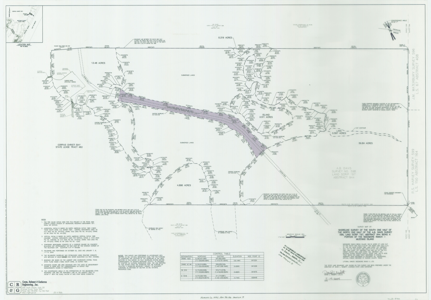
Nueces County NRC Article 33.136 Sketch 7
A Shoreline Survey of the South One Half of the North One Half of the A. B. Davis Survey 598, Land Scrip 197, Abstract 944, Being a Portion of the Needmore Ranch, Mustang Island
Nueces County NRC Article 33-136 Report 5
-
Map/Doc
81932
-
Collection
General Map Collection
-
Object Dates
2004/5/14 (Creation Date)
2004/5/21 (File Date)
-
People and Organizations
Coym, Rehmet & Gutierrez Engineering, Inc. (Publisher)
Coym, Rehmet & Gutierrez Engineering, Inc. (Printer)
David L. Nesbitt (Surveyor/Engineer)
-
Subjects
Surveying CBS
-
Height x Width
32.7 x 47.0 inches
83.1 x 119.4 cm
-
Medium
multi-page, multi-format
-
Comments
Survey located about 14 1/2 miles South 70 degrees East of Corpus Christi, Texas.
Part of: General Map Collection
Kimble County Working Sketch 9

Print $20.00
- Digital $50.00
Kimble County Working Sketch 9
1920
Size 14.3 x 17.3 inches
Map/Doc 70077
Map of Red River County

Print $20.00
- Digital $50.00
Map of Red River County
1856
Size 22.2 x 18.4 inches
Map/Doc 3981
Bastrop County Boundary File 6

Print $20.00
- Digital $50.00
Bastrop County Boundary File 6
Size 8.8 x 7.9 inches
Map/Doc 50337
Webb County Rolled Sketch 69

Print $20.00
- Digital $50.00
Webb County Rolled Sketch 69
1964
Size 13.9 x 22.3 inches
Map/Doc 8216
Victoria County Sketch File 8

Print $2.00
- Digital $50.00
Victoria County Sketch File 8
Size 5.7 x 5.6 inches
Map/Doc 39524
Flight Mission No. CUG-1P, Frame 107, Kleberg County

Print $20.00
- Digital $50.00
Flight Mission No. CUG-1P, Frame 107, Kleberg County
1956
Size 18.5 x 22.3 inches
Map/Doc 86157
Ector County Sketch File 2

Print $3.00
- Digital $50.00
Ector County Sketch File 2
1933
Size 19.4 x 16.1 inches
Map/Doc 11416
Bowie County Rolled Sketch 6A

Print $20.00
- Digital $50.00
Bowie County Rolled Sketch 6A
1992
Size 11.3 x 17.8 inches
Map/Doc 5162

Hale County Sketch File 24

Print $22.00
- Digital $50.00
Hale County Sketch File 24
1908
Size 8.9 x 7.9 inches
Map/Doc 24761
Sutton County Boundary File 5

Print $28.00
- Digital $50.00
Sutton County Boundary File 5
Size 14.2 x 8.7 inches
Map/Doc 59046
Montgomery County Working Sketch 18

Print $20.00
- Digital $50.00
Montgomery County Working Sketch 18
1935
Size 34.0 x 39.1 inches
Map/Doc 71125
You may also like
Webb County Sketch File 4-1

Print $6.00
- Digital $50.00
Webb County Sketch File 4-1
1874
Size 10.3 x 8.2 inches
Map/Doc 39722
Hidalgo County Rolled Sketch 7

Print $20.00
- Digital $50.00
Hidalgo County Rolled Sketch 7
1905
Size 20.4 x 26.1 inches
Map/Doc 6208
Amistad International Reservoir on Rio Grande 92

Print $20.00
- Digital $50.00
Amistad International Reservoir on Rio Grande 92
1950
Size 28.5 x 40.6 inches
Map/Doc 75522
Rockwall County Working Sketch 3

Print $20.00
- Digital $50.00
Rockwall County Working Sketch 3
1923
Size 22.6 x 18.7 inches
Map/Doc 63595
Parker County Working Sketch 23

Print $20.00
- Digital $50.00
Parker County Working Sketch 23
2007
Map/Doc 87924
Reeves County Sketch File 4

Print $20.00
- Digital $50.00
Reeves County Sketch File 4
Size 32.8 x 12.2 inches
Map/Doc 12240

Flight Mission No. CUG-3P, Frame 142, Kleberg County

Print $20.00
- Digital $50.00
Flight Mission No. CUG-3P, Frame 142, Kleberg County
1956
Size 18.7 x 22.3 inches
Map/Doc 86277
Cooke County Sketch File 33

Print $44.00
- Digital $50.00
Cooke County Sketch File 33
1873
Size 13.4 x 26.5 inches
Map/Doc 11174
Gaines County Sketch File 17

Print $32.00
- Digital $50.00
Gaines County Sketch File 17
1962
Size 11.3 x 8.8 inches
Map/Doc 23204
Flight Mission No. CRC-1R, Frame 37, Chambers County

Print $20.00
- Digital $50.00
Flight Mission No. CRC-1R, Frame 37, Chambers County
1956
Size 18.7 x 22.5 inches
Map/Doc 84705
Galveston County NRC Article 33.136 Sketch 83

Print $52.00
- Digital $50.00
Galveston County NRC Article 33.136 Sketch 83
2016
Size 22.5 x 34.0 inches
Map/Doc 94968