Webb County Sketch File 46
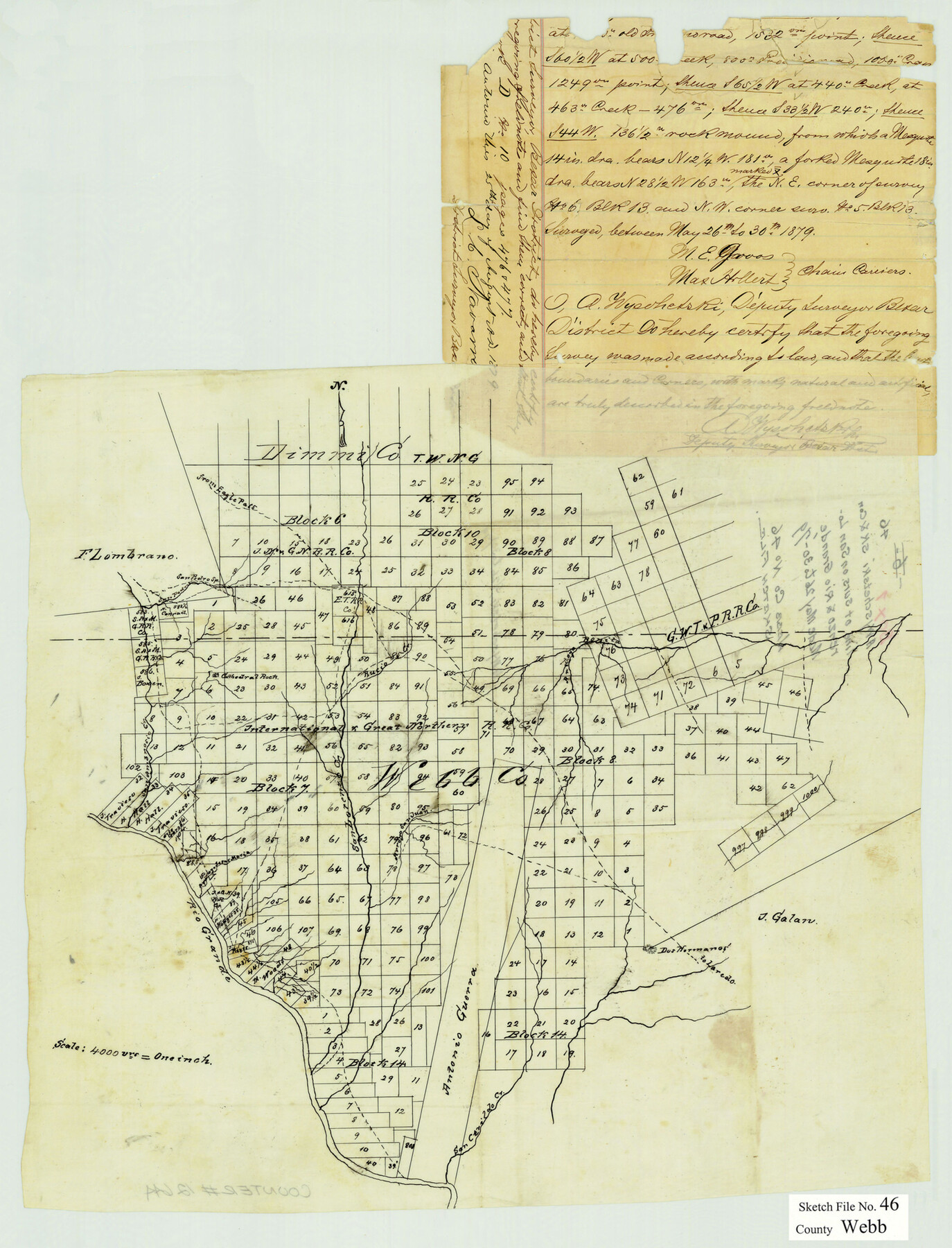
[Sketch of surveys in the northwest part of Webb County and southwest part of Dimmit County]
-
Map/Doc
12644
-
Collection
General Map Collection
-
Object Dates
5/30/1879 (Creation Date)
-
People and Organizations
M.E. Groos (Chainman/Field Personnel)
Max Hallert (Chainman/Field Personnel)
A. Wyschetzki (Surveyor/Engineer)
-
Counties
Webb Dimmit
-
Subjects
Surveying Sketch File
-
Height x Width
19.6 x 14.9 inches
49.8 x 37.9 cm
-
Medium
paper, manuscript
-
Scale
1" = 4000 varas
-
Features
[Road] from Eagle Pass
Arroya Bonita
San Pedro Spring
San Pedro Creek
Rucio Creek
San Anarosio Creek
Arroyo San Juan
San Lorenzo Creek
Arroyo de sus Mexia
Rio Grande
[Road to] Laredo
Dos Hermanos Hills
San Cerido Creek
Part of: General Map Collection
Harbor Pass and Bar at Brazos Santiago, Texas

Print $20.00
- Digital $50.00
Harbor Pass and Bar at Brazos Santiago, Texas
1871
Size 18.3 x 27.4 inches
Map/Doc 73036
Harris County NRC Article 33.136 Sketch 11

Print $28.00
- Digital $50.00
Harris County NRC Article 33.136 Sketch 11
2007
Size 24.0 x 36.0 inches
Map/Doc 94658
Motley County Sketch File 33 (S)

Print $6.00
- Digital $50.00
Motley County Sketch File 33 (S)
1914
Size 7.4 x 8.5 inches
Map/Doc 32217
Grayson County Boundary File 4a

Print $24.00
- Digital $50.00
Grayson County Boundary File 4a
Size 10.0 x 42.7 inches
Map/Doc 53956
Flight Mission No. DQO-2K, Frame 89, Galveston County

Print $20.00
- Digital $50.00
Flight Mission No. DQO-2K, Frame 89, Galveston County
1952
Size 18.6 x 22.3 inches
Map/Doc 85016
Floyd County Sketch File 12

Print $10.00
- Digital $50.00
Floyd County Sketch File 12
1913
Size 10.8 x 8.8 inches
Map/Doc 22708
McLennan County Working Sketch 3

Print $20.00
- Digital $50.00
McLennan County Working Sketch 3
1941
Size 18.0 x 17.9 inches
Map/Doc 70696
Flight Mission No. BRA-8M, Frame 140, Jefferson County

Print $20.00
- Digital $50.00
Flight Mission No. BRA-8M, Frame 140, Jefferson County
1953
Size 18.6 x 22.2 inches
Map/Doc 85632
Coke County Rolled Sketch 11

Print $20.00
- Digital $50.00
Coke County Rolled Sketch 11
1949
Size 32.6 x 26.3 inches
Map/Doc 5512
Orange County Working Sketch 27

Print $20.00
- Digital $50.00
Orange County Working Sketch 27
1953
Size 31.0 x 22.9 inches
Map/Doc 71359

Brewster County Working Sketch 74

Print $20.00
- Digital $50.00
Brewster County Working Sketch 74
1966
Size 24.8 x 32.0 inches
Map/Doc 67674
You may also like
Glasscock County Rolled Sketch 2

Print $20.00
- Digital $50.00
Glasscock County Rolled Sketch 2
1906
Size 19.6 x 14.8 inches
Map/Doc 6013

Map of Fort Worth & Denver City Railway

Print $40.00
- Digital $50.00
Map of Fort Worth & Denver City Railway
1880
Size 25.3 x 50.3 inches
Map/Doc 64416
The Chief Justice County of Gonzales. Lands in Conflict with Victoria County

Print $20.00
The Chief Justice County of Gonzales. Lands in Conflict with Victoria County
2020
Size 22.3 x 21.7 inches
Map/Doc 96048
Brewster County Rolled Sketch 114

Print $20.00
- Digital $50.00
Brewster County Rolled Sketch 114
1964
Size 11.0 x 18.3 inches
Map/Doc 5269
Montgomery County Working Sketch 74

Print $20.00
- Digital $50.00
Montgomery County Working Sketch 74
1981
Size 37.6 x 45.6 inches
Map/Doc 71181
Hutchinson County Rolled Sketch 44-6

Print $20.00
- Digital $50.00
Hutchinson County Rolled Sketch 44-6
2002
Size 24.0 x 36.0 inches
Map/Doc 77542
Taylor County Sketch File 18

Print $6.00
- Digital $50.00
Taylor County Sketch File 18
Size 11.6 x 7.3 inches
Map/Doc 37813

Atascosa County Rolled Sketch 17

Print $20.00
- Digital $50.00
Atascosa County Rolled Sketch 17
1953
Size 35.6 x 28.2 inches
Map/Doc 5097
[Sketch for Mineral Application 19144 - Pecos River Bed]
![65574, [Sketch for Mineral Application 19144 - Pecos River Bed], General Map Collection](https://historictexasmaps.com/wmedia_w700/maps/65574.tif.jpg)
Print $20.00
- Digital $50.00
[Sketch for Mineral Application 19144 - Pecos River Bed]
1927
Size 46.2 x 45.1 inches
Map/Doc 65574
Coke County Sketch File 23

Print $20.00
- Digital $50.00
Coke County Sketch File 23
Size 43.9 x 18.5 inches
Map/Doc 10338