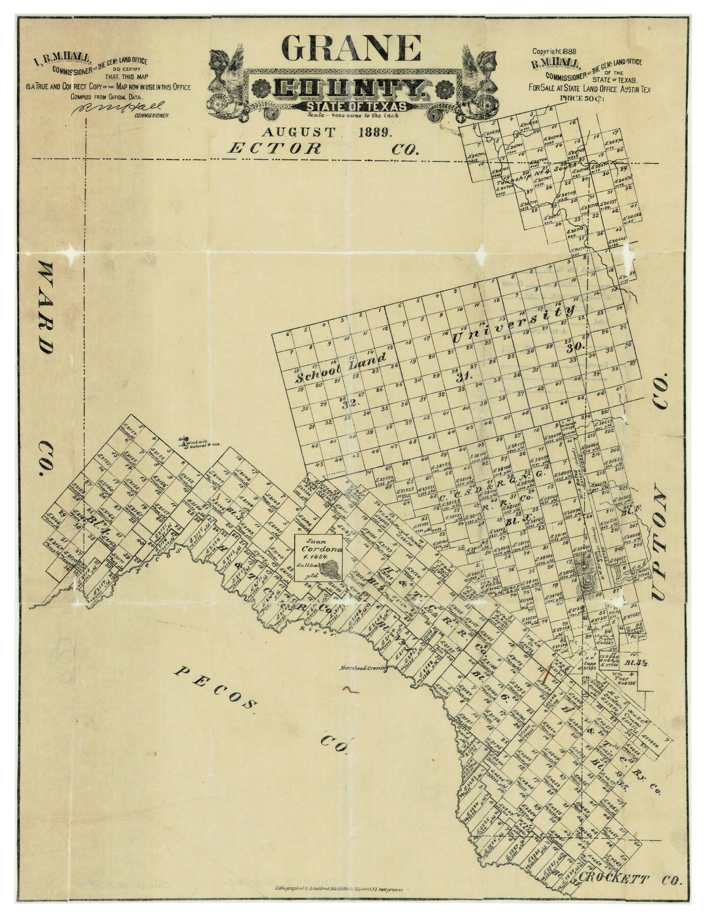
Crane County State of Texas
Crane County Sketch File 8
-
Map/Doc
4524
-
Collection
General Map Collection
-
Object Dates
8/1889 (Creation Date)
-
People and Organizations
R.M. Hall (GLO Commissioner)
August Gast Bank Note & Lithograph Company (Lithographer)
-
Counties
Crane
-
Subjects
County
-
Height x Width
22.9 x 17.6 inches
58.2 x 44.7 cm
-
Scale
1" = 4000 varas
-
Comments
Shows sketch of a windmill at Natural Wells.
"Lithographed by A. Gast Bank-Note & Litho. Co. St. Louis & N.Y. new process"
Copyright 1888.
Part of: General Map Collection
Erath County Sketch File 10

Print $4.00
- Digital $50.00
Erath County Sketch File 10
1871
Size 8.1 x 10.3 inches
Map/Doc 22275
Pecos County Working Sketch 18

Print $20.00
- Digital $50.00
Pecos County Working Sketch 18
1917
Size 18.4 x 20.9 inches
Map/Doc 71488
Dimmit County Sketch File 28

Print $40.00
- Digital $50.00
Dimmit County Sketch File 28
Size 14.7 x 17.4 inches
Map/Doc 11350
Victoria County Sketch File 5a

Print $2.00
- Digital $50.00
Victoria County Sketch File 5a
Size 8.2 x 12.9 inches
Map/Doc 39522
Tom Green County Sketch File 69

Print $40.00
- Digital $50.00
Tom Green County Sketch File 69
1945
Size 16.5 x 12.4 inches
Map/Doc 38239
Taylor County Sketch File 6

Print $40.00
- Digital $50.00
Taylor County Sketch File 6
Size 40.1 x 55.0 inches
Map/Doc 10382
Matagorda County Sketch File 16

Print $4.00
- Digital $50.00
Matagorda County Sketch File 16
Size 8.4 x 10.3 inches
Map/Doc 30780
Sterling County

Print $20.00
- Digital $50.00
Sterling County
1971
Size 45.6 x 33.9 inches
Map/Doc 95645
Ward County Boundary File 2

Print $4.00
- Digital $50.00
Ward County Boundary File 2
Size 11.1 x 8.9 inches
Map/Doc 59673

Flight Mission No. DQN-1K, Frame 35, Calhoun County

Print $20.00
- Digital $50.00
Flight Mission No. DQN-1K, Frame 35, Calhoun County
1953
Size 18.5 x 19.0 inches
Map/Doc 84140
Crockett County Sketch File F

Print $20.00
- Digital $50.00
Crockett County Sketch File F
1907
Size 26.3 x 15.7 inches
Map/Doc 11240
You may also like
Mason County Boundary File 5a

Print $40.00
- Digital $50.00
Mason County Boundary File 5a
Size 18.0 x 32.6 inches
Map/Doc 56872
[Sketch showing details along East line of Lipscomb County]
![89968, [Sketch showing details along East line of Lipscomb County], Twichell Survey Records](https://historictexasmaps.com/wmedia_w700/maps/89968-1.tif.jpg)
Print $40.00
- Digital $50.00
[Sketch showing details along East line of Lipscomb County]
Size 9.9 x 66.3 inches
Map/Doc 89968
[Maps of surveys in Reeves & Culberson Cos]
![61137, [Maps of surveys in Reeves & Culberson Cos], General Map Collection](https://historictexasmaps.com/wmedia_w700/maps/61137.tif.jpg)
Print $20.00
- Digital $50.00
[Maps of surveys in Reeves & Culberson Cos]
1937
Size 30.5 x 24.8 inches
Map/Doc 61137
Pecos County Rolled Sketch 130

Print $20.00
- Digital $50.00
Pecos County Rolled Sketch 130
1950
Size 20.1 x 27.7 inches
Map/Doc 7268
Pecos County Rolled Sketch 152

Print $20.00
- Digital $50.00
Pecos County Rolled Sketch 152
1960
Size 38.8 x 43.7 inches
Map/Doc 9736
Map of Texas Gulf Coast and Continental Shelf showing Natural Gas Pipe Lines

Print $40.00
- Digital $50.00
Map of Texas Gulf Coast and Continental Shelf showing Natural Gas Pipe Lines
1983
Size 40.9 x 59.1 inches
Map/Doc 75969
Red River County Working Sketch 44

Print $20.00
- Digital $50.00
Red River County Working Sketch 44
1968
Size 28.1 x 28.3 inches
Map/Doc 72027
Real County Rolled Sketch 18

Print $20.00
- Digital $50.00
Real County Rolled Sketch 18
Size 18.5 x 24.3 inches
Map/Doc 7462
Controlled Mosaic by Jack Amman Photogrammetric Engineers, Inc - Sheet 42

Print $20.00
- Digital $50.00
Controlled Mosaic by Jack Amman Photogrammetric Engineers, Inc - Sheet 42
1954
Size 20.0 x 24.0 inches
Map/Doc 83500
Crockett County Sketch File 70

Print $40.00
- Digital $50.00
Crockett County Sketch File 70
1931
Size 15.0 x 17.4 inches
Map/Doc 11232
Calhoun County Sketch File 10

Print $11.00
- Digital $50.00
Calhoun County Sketch File 10
1956
Size 14.3 x 8.8 inches
Map/Doc 35940
Flight Mission No. DQO-2K, Frame 133, Galveston County

Print $20.00
- Digital $50.00
Flight Mission No. DQO-2K, Frame 133, Galveston County
1952
Size 18.7 x 22.5 inches
Map/Doc 85030