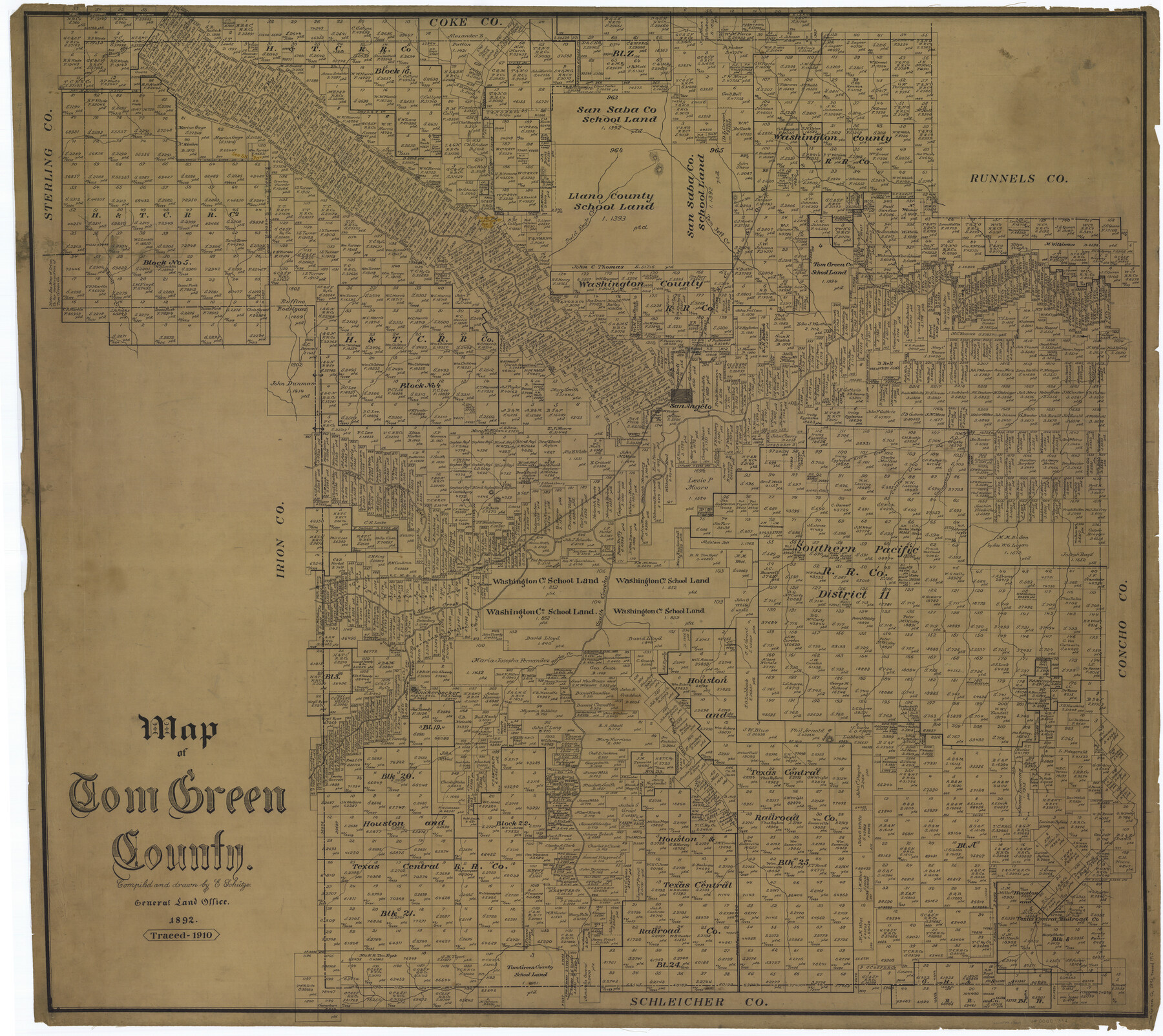
Map of Tom Green County
-
Map/Doc
63069
-
Collection
General Map Collection
-
Object Dates
1892 (Creation Date)
-
People and Organizations
Texas General Land Office (Publisher)
Ed. Schutze (Draftsman)
Ed. Schutze (Compiler)
-
Counties
Tom Green
-
Subjects
County
-
Height x Width
42.9 x 48.2 inches
109.0 x 122.4 cm
-
Comments
Traced in 1910.
Part of: General Map Collection
Sutton County Rolled Sketch 55

Print $40.00
- Digital $50.00
Sutton County Rolled Sketch 55
1954
Size 59.9 x 39.9 inches
Map/Doc 9976
Tarrant County

Print $20.00
- Digital $50.00
Tarrant County
1873
Size 19.6 x 18.0 inches
Map/Doc 4630
Harris County Sketch File 69a

Print $20.00
- Digital $50.00
Harris County Sketch File 69a
1938
Size 19.4 x 21.3 inches
Map/Doc 11663
Nueces County Rolled Sketch 49

Print $20.00
- Digital $50.00
Nueces County Rolled Sketch 49
1979
Size 21.1 x 20.7 inches
Map/Doc 6888
[Sketch for Mineral Application 33721 - 33725 Incl. - Padre and Mustang Island]
![2875, [Sketch for Mineral Application 33721 - 33725 Incl. - Padre and Mustang Island], General Map Collection](https://historictexasmaps.com/wmedia_w700/maps/2875.tif.jpg)
Print $20.00
- Digital $50.00
[Sketch for Mineral Application 33721 - 33725 Incl. - Padre and Mustang Island]
1942
Size 30.9 x 22.0 inches
Map/Doc 2875
Hutchinson County Rolled Sketch 44-6

Print $20.00
- Digital $50.00
Hutchinson County Rolled Sketch 44-6
2002
Size 24.0 x 36.0 inches
Map/Doc 77542
[Galveston, Harrisburg & San Antonio Railroad from Cuero to Stockdale]
![64195, [Galveston, Harrisburg & San Antonio Railroad from Cuero to Stockdale], General Map Collection](https://historictexasmaps.com/wmedia_w700/maps/64195.tif.jpg)
Print $20.00
- Digital $50.00
[Galveston, Harrisburg & San Antonio Railroad from Cuero to Stockdale]
1907
Size 14.0 x 34.1 inches
Map/Doc 64195
Parker County Sketch File 9a

Print $4.00
- Digital $50.00
Parker County Sketch File 9a
1859
Size 9.0 x 7.7 inches
Map/Doc 33540
Henderson County Sketch File 19

Print $4.00
- Digital $50.00
Henderson County Sketch File 19
Size 9.1 x 8.9 inches
Map/Doc 26363
Harris County

Print $40.00
- Digital $50.00
Harris County
1896
Size 44.8 x 67.5 inches
Map/Doc 66856
Kimble County Working Sketch 8

Print $20.00
- Digital $50.00
Kimble County Working Sketch 8
1918
Size 27.4 x 12.9 inches
Map/Doc 70076
Parker County Sketch File 41

Print $4.00
- Digital $50.00
Parker County Sketch File 41
1877
Size 8.9 x 10.6 inches
Map/Doc 33587
You may also like
Shackelford County Sketch File 16

Print $24.00
- Digital $50.00
Shackelford County Sketch File 16
2005
Size 16.0 x 16.0 inches
Map/Doc 82982
Right-of-Way and Track Map, Texas State Railroad operated by the T. and N.O. R.R. Co.

Print $40.00
- Digital $50.00
Right-of-Way and Track Map, Texas State Railroad operated by the T. and N.O. R.R. Co.
1917
Size 25.2 x 56.1 inches
Map/Doc 64171
Frio County Sketch File 1

Print $8.00
- Digital $50.00
Frio County Sketch File 1
1848
Size 8.6 x 7.7 inches
Map/Doc 23101
[Nathaniel H. Cochran Survey and Vicinity]
![91497, [Nathaniel H. Cochran Survey and Vicinity], Twichell Survey Records](https://historictexasmaps.com/wmedia_w700/maps/91497-1.tif.jpg)
Print $20.00
- Digital $50.00
[Nathaniel H. Cochran Survey and Vicinity]
Size 25.5 x 18.8 inches
Map/Doc 91497
McMullen County, Texas

Print $20.00
- Digital $50.00
McMullen County, Texas
1889
Size 28.7 x 22.1 inches
Map/Doc 575
Township 12 South Range 13 West, South Western District, Louisiana

Print $20.00
- Digital $50.00
Township 12 South Range 13 West, South Western District, Louisiana
1838
Size 19.5 x 24.7 inches
Map/Doc 65855
Kerr County State Real Property Sketch 1

Print $20.00
- Digital $50.00
Kerr County State Real Property Sketch 1
2007
Size 24.9 x 35.1 inches
Map/Doc 88669
Hutchinson County Rolled Sketch 44-3

Print $20.00
- Digital $50.00
Hutchinson County Rolled Sketch 44-3
2002
Size 24.0 x 36.0 inches
Map/Doc 77539
Menard County

Print $20.00
- Digital $50.00
Menard County
1942
Size 42.2 x 44.4 inches
Map/Doc 95588
Location of the Southern Kansas Railway of Texas, Carson County, Texas

Print $40.00
- Digital $50.00
Location of the Southern Kansas Railway of Texas, Carson County, Texas
1887
Size 20.5 x 84.3 inches
Map/Doc 64035
Denton County Working Sketch 18

Print $20.00
- Digital $50.00
Denton County Working Sketch 18
1975
Size 24.1 x 38.8 inches
Map/Doc 68623
Schleicher County Rolled Sketch 19

Print $20.00
- Digital $50.00
Schleicher County Rolled Sketch 19
Size 25.0 x 21.9 inches
Map/Doc 7761