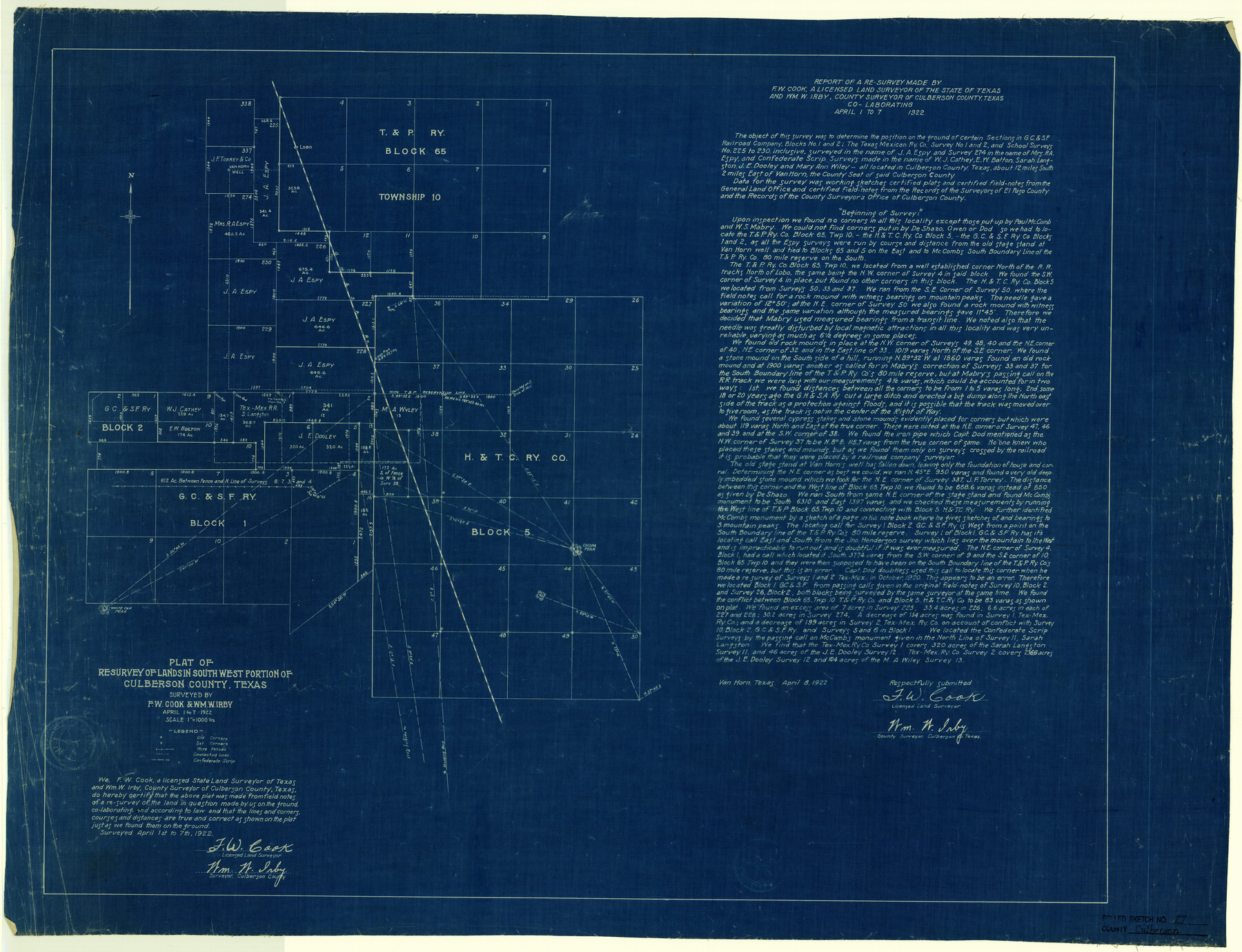
Culberson County Rolled Sketch 27
Plat of resurvey of lands in southwest portion of Culberson County, Texas
-
Map/Doc
5656
-
Collection
General Map Collection
-
Object Dates
1922/4/7 (Survey Date)
1922/9/2 (File Date)
1922/4/8 (Creation Date)
-
People and Organizations
Wm. W. Irby (Surveyor/Engineer)
F.W. Cook (Surveyor/Engineer)
-
Counties
Culberson
-
Subjects
Surveying Rolled Sketch
-
Height x Width
26.8 x 34.9 inches
68.1 x 88.6 cm
-
Medium
blueprint/diazo
-
Scale
1" = 1000 varas
Part of: General Map Collection
Matagorda County Sketch File 46

Print $107.00
- Digital $50.00
Matagorda County Sketch File 46
1985
Size 11.2 x 8.5 inches
Map/Doc 30932
Newton County Rolled Sketch 20

Print $40.00
- Digital $50.00
Newton County Rolled Sketch 20
1956
Size 41.4 x 48.0 inches
Map/Doc 9581
Uvalde County

Print $20.00
- Digital $50.00
Uvalde County
1976
Size 42.0 x 45.4 inches
Map/Doc 77444
Dawson County Sketch File 18

Print $10.00
- Digital $50.00
Dawson County Sketch File 18
1940
Size 14.2 x 9.0 inches
Map/Doc 20567
Map of the State of Texas from the Latest Authorities

Print $20.00
- Digital $50.00
Map of the State of Texas from the Latest Authorities
1853
Size 14.2 x 17.4 inches
Map/Doc 89221
Irion County Sketch File 8

Print $6.00
- Digital $50.00
Irion County Sketch File 8
Size 14.5 x 9.8 inches
Map/Doc 27473
Brewster County Rolled Sketch 53

Print $20.00
- Digital $50.00
Brewster County Rolled Sketch 53
1934
Size 43.8 x 37.6 inches
Map/Doc 8480
Jones County Sketch File 9

Print $22.00
- Digital $50.00
Jones County Sketch File 9
Size 8.3 x 7.5 inches
Map/Doc 28495
The south west and N.E. lines of Mary Thomas and A. Morrallis surveys

Print $2.00
- Digital $50.00
The south west and N.E. lines of Mary Thomas and A. Morrallis surveys
1847
Size 9.4 x 8.1 inches
Map/Doc 336
Throckmorton County Working Sketch 2

Print $20.00
- Digital $50.00
Throckmorton County Working Sketch 2
1919
Size 20.9 x 16.9 inches
Map/Doc 62111
Controlled Mosaic by Jack Amman Photogrammetric Engineers, Inc - Sheet 52

Print $20.00
- Digital $50.00
Controlled Mosaic by Jack Amman Photogrammetric Engineers, Inc - Sheet 52
1954
Size 20.0 x 24.0 inches
Map/Doc 83511
Navarro County Working Sketch 1c

Print $2.00
- Digital $50.00
Navarro County Working Sketch 1c
Size 7.1 x 10.6 inches
Map/Doc 71231
You may also like


Orange County Working Sketch 3

Print $20.00
- Digital $50.00
Orange County Working Sketch 3
1917
Size 12.7 x 20.3 inches
Map/Doc 71335
Jefferson County Sketch File 15a

Print $8.00
- Digital $50.00
Jefferson County Sketch File 15a
1872
Size 15.6 x 6.7 inches
Map/Doc 28156
Howard County Working Sketch 7b

Print $40.00
- Digital $50.00
Howard County Working Sketch 7b
1950
Size 83.3 x 25.6 inches
Map/Doc 66274
Mills County Boundary File 9

Print $40.00
- Digital $50.00
Mills County Boundary File 9
Size 13.7 x 8.6 inches
Map/Doc 57318
[Texas Boundary Line]
![92075, [Texas Boundary Line], Twichell Survey Records](https://historictexasmaps.com/wmedia_w700/maps/92075-1.tif.jpg)
Print $20.00
- Digital $50.00
[Texas Boundary Line]
Size 21.4 x 11.9 inches
Map/Doc 92075
Kerr County Working Sketch 18

Print $20.00
- Digital $50.00
Kerr County Working Sketch 18
1956
Size 25.4 x 29.3 inches
Map/Doc 70049
The Western Coast of Louisiana and The Coast of New Leon

Print $20.00
- Digital $50.00
The Western Coast of Louisiana and The Coast of New Leon
1775
Size 21.1 x 28.7 inches
Map/Doc 93705
Young County Working Sketch 25

Print $20.00
- Digital $50.00
Young County Working Sketch 25
1982
Size 12.6 x 14.4 inches
Map/Doc 62048
General Highway Map. Detail of Cities and Towns in Williamson County, Texas [Round Rock, Taylor, Georgetown]
![79714, General Highway Map. Detail of Cities and Towns in Williamson County, Texas [Round Rock, Taylor, Georgetown], Texas State Library and Archives](https://historictexasmaps.com/wmedia_w700/maps/79714.tif.jpg)
Print $20.00
General Highway Map. Detail of Cities and Towns in Williamson County, Texas [Round Rock, Taylor, Georgetown]
1961
Size 18.2 x 24.8 inches
Map/Doc 79714
Hemphill County Rolled Sketch 2

Print $20.00
- Digital $50.00
Hemphill County Rolled Sketch 2
Size 26.4 x 29.8 inches
Map/Doc 6185