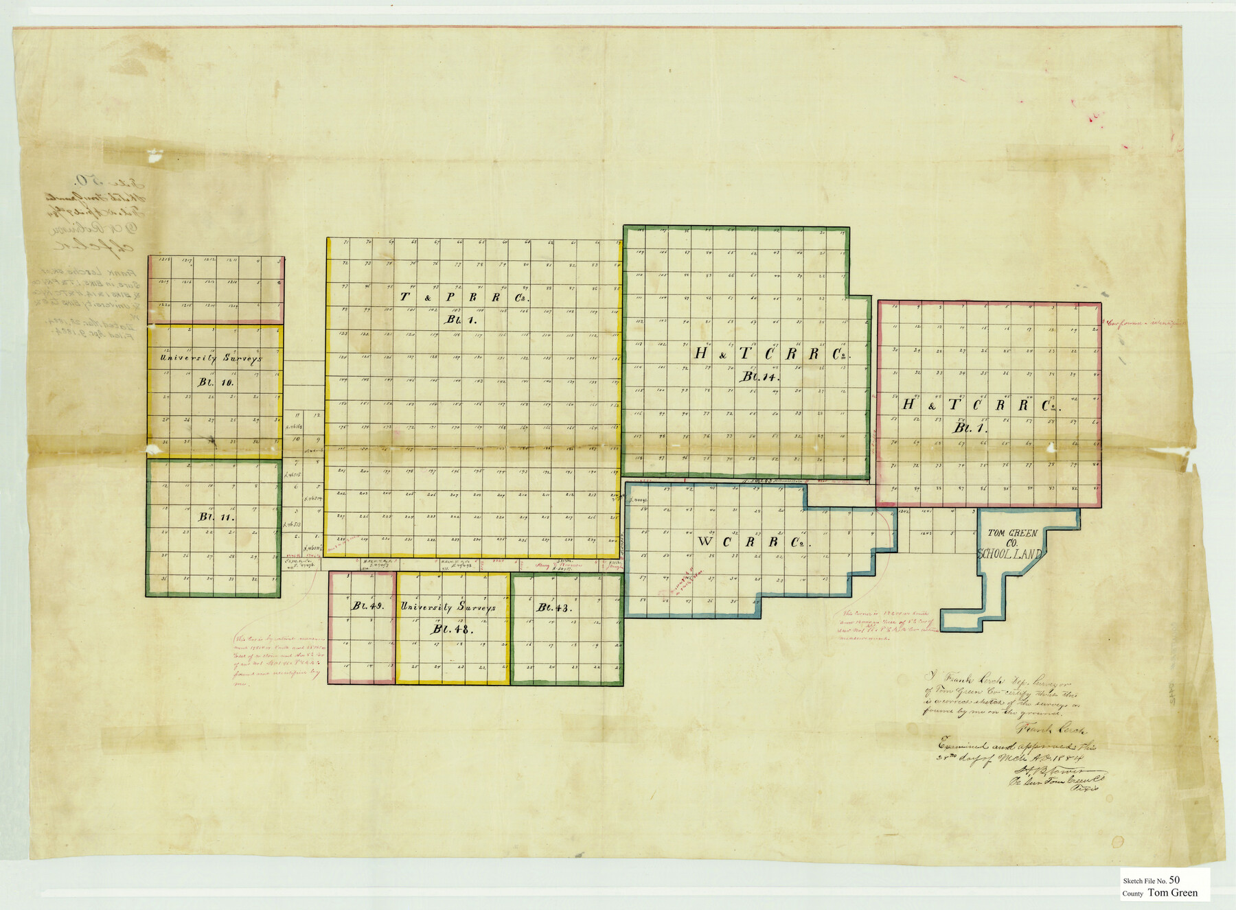
Tom Green County Sketch File 50
[Large sketch of University Blocks 10, 11, 43, 48, and 49, T. & P. Block 1, H. & T. C. R.R. Co. Blocks 1 and 14, W. C. R.R. Co. Block, and Tom Green County School Land in Irion and Reagan Counties]
-
Map/Doc
12442
-
Collection
General Map Collection
-
Object Dates
3/28/1884 (Creation Date)
4/9/1884 (File Date)
-
People and Organizations
Frank Lerch (Surveyor/Engineer)
-
Counties
Irion Reagan
-
Subjects
Surveying Sketch File
-
Height x Width
25.4 x 34.5 inches
64.5 x 87.6 cm
-
Medium
paper, manuscript
Part of: General Map Collection

Newton County Sketch File 11

Print $4.00
- Digital $50.00
Newton County Sketch File 11
1876
Size 7.9 x 12.7 inches
Map/Doc 32380
Jasper County Working Sketch 32

Print $20.00
- Digital $50.00
Jasper County Working Sketch 32
1993
Size 18.7 x 22.7 inches
Map/Doc 66494
Texas Coordinate File 7

Print $4.00
- Digital $50.00
Texas Coordinate File 7
Size 11.3 x 8.8 inches
Map/Doc 75316
Tom Green County Sketch File 74

Print $6.00
- Digital $50.00
Tom Green County Sketch File 74
1950
Size 11.3 x 8.9 inches
Map/Doc 38250
[Sketch for Mineral Application 11108 - Greens Bayou]
![2786, [Sketch for Mineral Application 11108 - Greens Bayou], General Map Collection](https://historictexasmaps.com/wmedia_w700/maps/2786-1.tif.jpg)
Print $20.00
- Digital $50.00
[Sketch for Mineral Application 11108 - Greens Bayou]
1922
Size 46.0 x 21.0 inches
Map/Doc 2786
Map of the Rio Grande & Eagle Pass Ry. from Sections 14-20 Inclusive, Webb County

Print $40.00
- Digital $50.00
Map of the Rio Grande & Eagle Pass Ry. from Sections 14-20 Inclusive, Webb County
1909
Size 25.3 x 55.6 inches
Map/Doc 64657
A New Map of Texas with the contiguous American and Mexican States

Print $20.00
- Digital $50.00
A New Map of Texas with the contiguous American and Mexican States
1839
Size 13.0 x 15.4 inches
Map/Doc 96513
Reeves County Rolled Sketch 24

Print $20.00
- Digital $50.00
Reeves County Rolled Sketch 24
1982
Size 37.2 x 24.9 inches
Map/Doc 7493
Flight Mission No. BRA-3M, Frame 192, Jefferson County

Print $20.00
- Digital $50.00
Flight Mission No. BRA-3M, Frame 192, Jefferson County
1953
Size 18.5 x 22.4 inches
Map/Doc 85407
Lighthouse establishment on the Atlantic and Gulf Coasts and coast signal stations

Print $20.00
- Digital $50.00
Lighthouse establishment on the Atlantic and Gulf Coasts and coast signal stations
1898
Size 25.1 x 18.3 inches
Map/Doc 73051
Liberty County Working Sketch 17

Print $20.00
- Digital $50.00
Liberty County Working Sketch 17
1934
Size 34.5 x 24.0 inches
Map/Doc 70476
You may also like
Harris County Rolled Sketch 79

Print $20.00
- Digital $50.00
Harris County Rolled Sketch 79
1955
Size 30.4 x 25.0 inches
Map/Doc 6115
Bee County Sketch File Y

Print $4.00
- Digital $50.00
Bee County Sketch File Y
Size 8.8 x 5.4 inches
Map/Doc 14255
Presidio County Sketch File 116

Print $86.00
- Digital $50.00
Presidio County Sketch File 116
1993
Size 11.4 x 8.7 inches
Map/Doc 34842

Presidio County Working Sketch Graphic Index, West Part, Sheet 1 (Sketches 1 to 74)

Print $20.00
- Digital $50.00
Presidio County Working Sketch Graphic Index, West Part, Sheet 1 (Sketches 1 to 74)
1974
Size 40.3 x 31.4 inches
Map/Doc 76672
Map of the River Sabine from its mouth on the Gulf of Mexico in the sea to Logan's Ferry in latitude 31° 58' 24" north

Print $20.00
- Digital $50.00
Map of the River Sabine from its mouth on the Gulf of Mexico in the sea to Logan's Ferry in latitude 31° 58' 24" north
1842
Size 18.5 x 9.0 inches
Map/Doc 65384
McMullen County Sketch File 8

Print $4.00
- Digital $50.00
McMullen County Sketch File 8
1876
Size 8.6 x 8.8 inches
Map/Doc 31349
Tarrant County Sketch File 23

Print $4.00
- Digital $50.00
Tarrant County Sketch File 23
Size 6.1 x 8.2 inches
Map/Doc 37733
Tom Green County Sketch File 79A

Print $4.00
- Digital $50.00
Tom Green County Sketch File 79A
1970
Size 14.5 x 8.8 inches
Map/Doc 38258
Delta County Sketch File 1

Print $4.00
- Digital $50.00
Delta County Sketch File 1
1871
Size 12.7 x 8.1 inches
Map/Doc 20666
Gillespie County Working Sketch 11

Print $20.00
- Digital $50.00
Gillespie County Working Sketch 11
2007
Size 27.8 x 38.0 inches
Map/Doc 87212
D. B. Gardner vs. Mrs. Clara C. Starr

Print $20.00
- Digital $50.00
D. B. Gardner vs. Mrs. Clara C. Starr
Size 16.7 x 28.8 inches
Map/Doc 92149